Orland elevation
Orland (California, Glenn County), United States elevation is 80 meters and Orland elevation in feet is 262 ft above sea level [src 1]. Orland is a populated place (feature code) with elevation that is 199 meters (653 ft) smaller than average city elevation in United States.
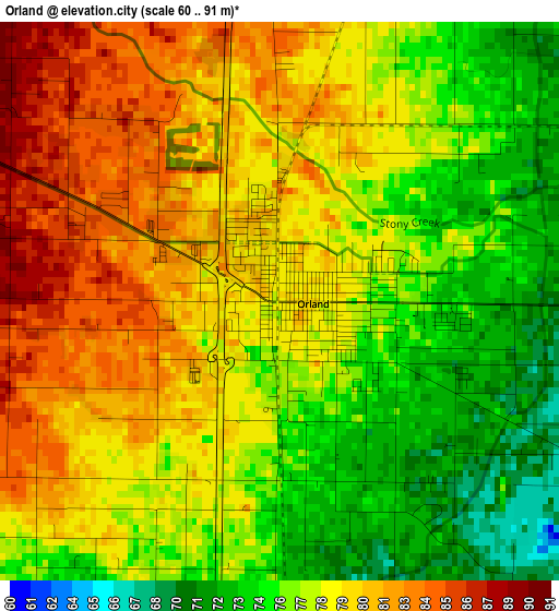
Below is the Elevation map of Orland, which displays elevation range with different colors. Scale of the first map is from 60 to 91 m (197 to 299 ft) with average elevation of 78 meters (=256 ft) [note 1]
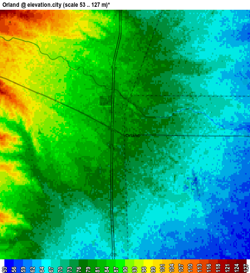
These maps also provides idea of topography and contour of this city, they are displayed at different zoom levels. More info about maps, scale and edge coordinates you can find below images.
| \ | Map #1 | Map #2 | Topo.Map |
| Scale [m] | 60..91 m | 53..127 m | × |
| Scale [ft] | 197..299 ft | 174..417 ft | × |
| Average | 78 m = 256 ft | 76.9 m = 252 ft | × |
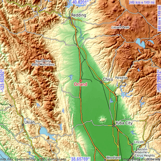
| Width | 7.51 km = 4.7 mi | 15.03 km = 9.3 mi | 240.4 km = 149.4 mi |
| Height | 7.51 km = 4.7 mi | 15.03 km = 9.3 mi | 240.4 km = 149.4 mi |
| ↑Max Latitude | 39.78116° | 39.814923° | 40.8201° |
| Latitude at center | 39.74738° | 39.74738° | 39.74738° |
| ↓Min Latitude | 39.713583° | 39.67977° | 38.65769° |
| ← Min Longitude | -122.240315° | -122.284261° | -123.60262° |
| Longitude center | -122.19637° | -122.19637° | -122.19637° |
| →Max Longitude | -122.152425° | -122.108479° | -120.79012° |
Nearby cities:
Cities around Orland sort by population:
• Chico elevation 64 m
30.8 km,  93°
93°
• Paradise 543 m
49.1 km, 88°
• Red Bluff 94 m
48.1 km,  355°
355°
• Corning 85 m
20.1 km,  4°
4°
• Willows 43 m
24.8 km,  179°
179°
• Durham 47 m
35.7 km,  108°
108°
• Los Molinos 70 m
31.5 km,  15°
15°
• Hamilton City 48 m
15.6 km, 91°
• Rancho Tehama Reserve 168 m
34.6 km,  329°
329°
• Forest Ranch 741 m
47.2 km,  71°
71°
• Maxwell 28 m
52.4 km, 179°
• Gerber 71 m
34.6 km,  6°
6°
Multilingual:
 En español:
Orland elevación 80 m.
 En France:
Orland élévation 80 m.


Sources and notes:
- [note 1] Map square and city borders are not equal. Map elevation data is calculated only from area inside that square.
- [src 1] Elevation data from geonames database provided with same terms of usage.
- [src 2] The elevation map of Orland is generated using elevation data from NASA's 3 arcsec (90m) resolution SRTM data.
- [src 3] Base (background) map © OpenStreetMap contributors tiles are generated by Geofabrik and OpenTopoMap.
Copyright & License:
This Orland Elevation Map is licensed under CC BY-SA. You may reuse any part from this page, if you give a proper credit by linking to this URL:
 More info on terms of use page.