Apache Junction elevation
Apache Junction (Arizona, Pinal County), United States elevation is 526 meters and Apache Junction elevation in feet is 1726 ft above sea level [src 1]. Apache Junction is a populated place (feature code) with elevation that is 247 meters (810 ft) bigger than average city elevation in United States.
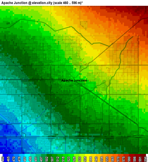
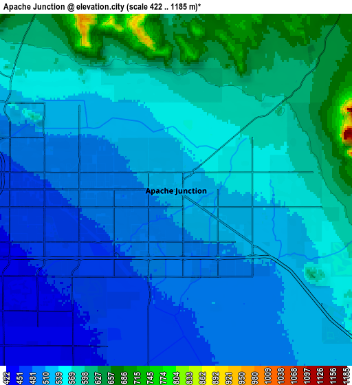
Below is the Elevation map of Apache Junction, which displays elevation range with different colors. Scale of the first map is from 460 to 596 m (1509 to 1955 ft) with average elevation of 520.5 meters (=1708 ft) [note 1]
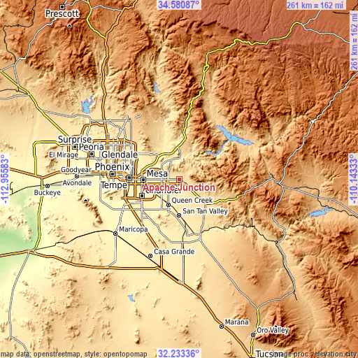
These maps also provides idea of topography and contour of this city, they are displayed at different zoom levels. More info about maps, scale and edge coordinates you can find below images.
| \ | Map #1 | Map #2 | Topo.Map |
| Scale [m] | 460..596 m | 422..1185 m | × |
| Scale [ft] | 1509..1955 ft | 1385..3888 ft | × |
| Average | 520.5 m = 1708 ft | 543.6 m = 1783 ft | × |
| Width | 8.16 km = 5.1 mi | 16.31 km = 10.1 mi | 261 km = 162.2 mi |
| Height | 8.16 km = 5.1 mi | 16.31 km = 10.1 mi | 261 km = 162.2 mi |
| ↑Max Latitude | 33.451724° | 33.488382° | 34.58087° |
| Latitude at center | 33.41505° | 33.41505° | 33.41505° |
| ↓Min Latitude | 33.378361° | 33.341656° | 32.23336° |
| ← Min Longitude | -111.593525° | -111.637471° | -112.95583° |
| Longitude center | -111.54958° | -111.54958° | -111.54958° |
| →Max Longitude | -111.505635° | -111.461689° | -110.14333° |
Nearby cities:
Cities around Apache Junction sort by population:
• Mesa elevation 380 m
25.4 km,  271°
271°
• Chandler 368 m
29.7 km,  245°
245°
• Gilbert 377 m
23.3 km, 252°
• Scottsdale 382 m
34.1 km,  287°
287°
• Tempe 360 m
33.4 km, 269°
• San Tan Valley 461 m
25 km,  175°
175°
• Queen Creek 428 m
20.1 km,  203°
203°
• Fountain Hills 494 m
26.8 km,  324°
324°
• Gold Camp 610 m
26.5 km,  120°
120°
• Gold Canyon 579 m
11.5 km,  114°
114°
• San Carlos 367 m
29 km, 254°
• Rio Verde 494 m
36.1 km,  341°
341°
Multilingual:
 En español:
Apache Junction elevación 526 m.
 En France:
Apache Junction élévation 526 m.
 Auf Deutsch:
Apache Junction höhe über dem Meeresspiegel ist 526 m.

Sources and notes:
- [note 1] Map square and city borders are not equal. Map elevation data is calculated only from area inside that square.
- [src 1] Elevation data from geonames database provided with same terms of usage.
- [src 2] The elevation map of Apache Junction is generated using elevation data from NASA's 3 arcsec (90m) resolution SRTM data.
- [src 3] Base (background) map © OpenStreetMap contributors tiles are generated by Geofabrik and OpenTopoMap.
Copyright & License:
This Apache Junction Elevation Map is licensed under CC BY-SA. You may reuse any part from this page, if you give a proper credit by linking to this URL:
 More info on terms of use page.