Chandler elevation
Chandler (Arizona, Maricopa County), United States elevation is 368 meters and Chandler elevation in feet is 1207 ft above sea level [src 1]. Chandler is a populated place (feature code) with elevation that is 89 meters (292 ft) bigger than average city elevation in United States.
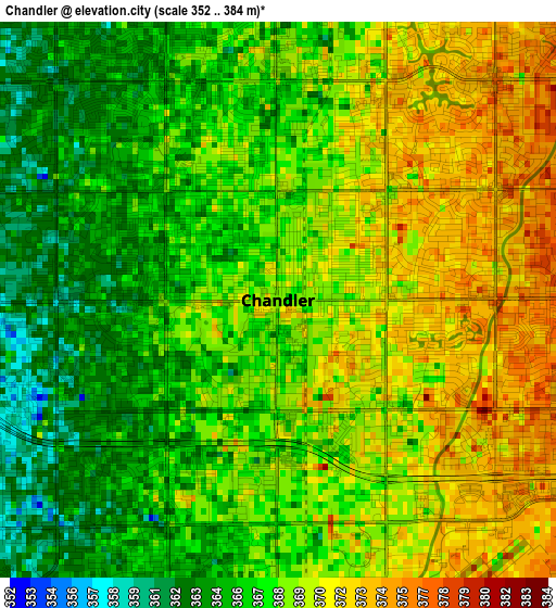
Below is the Elevation map of Chandler, which displays elevation range with different colors. Scale of the first map is from 352 to 384 m (1155 to 1260 ft) with average elevation of 368.1 meters (=1208 ft) [note 1]
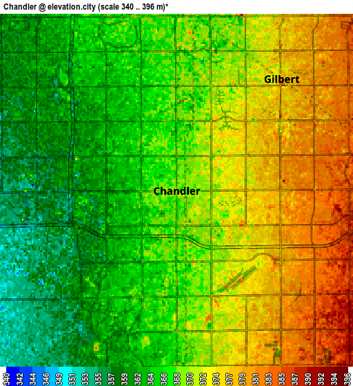
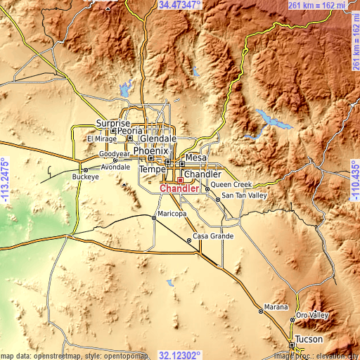
These maps also provides idea of topography and contour of this city, they are displayed at different zoom levels. More info about maps, scale and edge coordinates you can find below images.
| \ | Map #1 | Map #2 | Topo.Map |
| Scale [m] | 352..384 m | 340..396 m | × |
| Scale [ft] | 1155..1260 ft | 1115..1299 ft | × |
| Average | 368.1 m = 1208 ft | 368.8 m = 1210 ft | × |
| Width | 8.17 km = 5.1 mi | 16.33 km = 10.1 mi | 261.3 km = 162.4 mi |
| Height | 8.17 km = 5.1 mi | 16.33 km = 10.1 mi | 261.3 km = 162.4 mi |
| ↑Max Latitude | 33.342879° | 33.379583° | 34.47347° |
| Latitude at center | 33.30616° | 33.30616° | 33.30616° |
| ↓Min Latitude | 33.269425° | 33.232675° | 32.12302° |
| ← Min Longitude | -111.885195° | -111.929141° | -113.2475° |
| Longitude center | -111.84125° | -111.84125° | -111.84125° |
| →Max Longitude | -111.797305° | -111.753359° | -110.435° |
Nearby cities:
Cities around Chandler sort by population:
• Mesa elevation 380 m
13 km,  7°
7°
• Gilbert 377 m
7.1 km,  43°
43°
• Scottsdale 382 m
23.2 km,  346°
346°
• Tempe 360 m
13.6 km,  332°
332°
• Tempe Junction 352 m
15.3 km,  321°
321°
• Ahwatukee Foothills 386 m
13.8 km,  286°
286°
• Central City 341 m
25 km,  306°
306°
• Queen Creek 428 m
20.3 km,  108°
108°
• Sun Lakes 362 m
11 km,  196°
196°
• Guadalupe 376 m
13.4 km,  302°
302°
• San Carlos 367 m
4.5 km, 348°
• Casa Blanca 361 m
21.1 km,  191°
191°
Multilingual:
 En español:
Chandler elevación 368 m.
 En France:
Chandler élévation 368 m.
 Auf Deutsch:
Chandler höhe über dem Meeresspiegel ist 368 m.

Sources and notes:
- [note 1] Map square and city borders are not equal. Map elevation data is calculated only from area inside that square.
- [src 1] Elevation data from geonames database provided with same terms of usage.
- [src 2] The elevation map of Chandler is generated using elevation data from NASA's 3 arcsec (90m) resolution SRTM data.
- [src 3] Base (background) map © OpenStreetMap contributors tiles are generated by Geofabrik and OpenTopoMap.
Copyright & License:
This Chandler Elevation Map is licensed under CC BY-SA. You may reuse any part from this page, if you give a proper credit by linking to this URL:
 More info on terms of use page.