Ahwatukee Foothills elevation
Ahwatukee Foothills (Arizona, Maricopa County), United States elevation is 386 meters and Ahwatukee Foothills elevation in feet is 1266 ft above sea level [src 1]. Ahwatukee Foothills is a populated place (feature code) with elevation that is 107 meters (351 ft) bigger than average city elevation in United States.
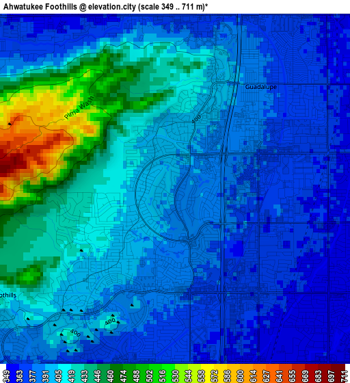
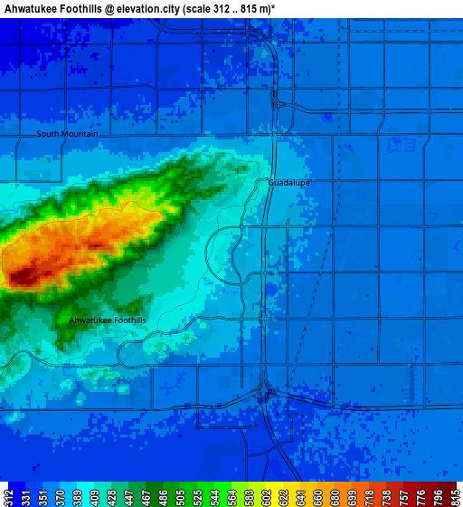
Below is the Elevation map of Ahwatukee Foothills, which displays elevation range with different colors. Scale of the first map is from 349 to 711 m (1145 to 2333 ft) with average elevation of 403.8 meters (=1325 ft) [note 1]
These maps also provides idea of topography and contour of this city, they are displayed at different zoom levels. More info about maps, scale and edge coordinates you can find below images.
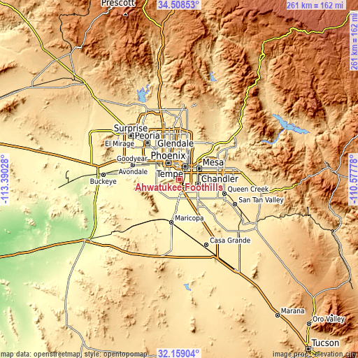
| \ | Map #1 | Map #2 | Topo.Map |
| Scale [m] | 349..711 m | 312..815 m | × |
| Scale [ft] | 1145..2333 ft | 1024..2674 ft | × |
| Average | 403.8 m = 1325 ft | 383.6 m = 1259 ft | × |
| Width | 8.16 km = 5.1 mi | 16.33 km = 10.1 mi | 261.2 km = 162.3 mi |
| Height | 8.16 km = 5.1 mi | 16.33 km = 10.1 mi | 261.2 km = 162.3 mi |
| ↑Max Latitude | 33.378415° | 33.415104° | 34.50853° |
| Latitude at center | 33.34171° | 33.34171° | 33.34171° |
| ↓Min Latitude | 33.30499° | 33.268255° | 32.15904° |
| ← Min Longitude | -112.027975° | -112.071921° | -113.39028° |
| Longitude center | -111.98403° | -111.98403° | -111.98403° |
| →Max Longitude | -111.940085° | -111.896139° | -110.57778° |
Nearby cities:
Cities around Ahwatukee Foothills sort by population:
• Phoenix elevation 366 m
14.5 km,  324°
324°
• Mesa 380 m
17.5 km,  59°
59°
• Chandler 368 m
13.8 km,  106°
106°
• Gilbert 377 m
18.2 km,  86°
86°
• Tempe 360 m
10.7 km,  40°
40°
• Tempe Junction 352 m
8.9 km,  25°
25°
• Central City 341 m
12.9 km,  327°
327°
• Encanto 350 m
17.6 km, 330°
• Sun Lakes 362 m
17.7 km,  145°
145°
• Guadalupe 376 m
3.8 km, 31°
• Laveen 315 m
17.4 km,  277°
277°
• San Carlos 367 m
12.4 km, 87°
Multilingual:
 En español:
Ahwatukee Foothills elevación 386 m.
 En France:
Ahwatukee Foothills élévation 386 m.
 Auf Deutsch:
Ahwatukee Foothills höhe über dem Meeresspiegel ist 386 m.
 На русском:
Ahwatukee Foothills высота над уровнем моря 386 м
Sources and notes:
- [note 1] Map square and city borders are not equal. Map elevation data is calculated only from area inside that square.
- [src 1] Elevation data from geonames database provided with same terms of usage.
- [src 2] The elevation map of Ahwatukee Foothills is generated using elevation data from NASA's 3 arcsec (90m) resolution SRTM data.
- [src 3] Base (background) map © OpenStreetMap contributors tiles are generated by Geofabrik and OpenTopoMap.
Copyright & License:
This Ahwatukee Foothills Elevation Map is licensed under CC BY-SA. You may reuse any part from this page, if you give a proper credit by linking to this URL:
 More info on terms of use page.