Rio Verde elevation
Rio Verde (Arizona, Maricopa County), United States elevation is 494 meters and Rio Verde elevation in feet is 1621 ft above sea level [src 1]. Rio Verde is a populated place (feature code) with elevation that is 215 meters (705 ft) bigger than average city elevation in United States.
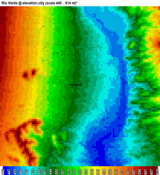
Below is the Elevation map of Rio Verde, which displays elevation range with different colors. Scale of the first map is from 440 to 614 m (1444 to 2014 ft) with average elevation of 510.7 meters (=1676 ft) [note 1]
These maps also provides idea of topography and contour of this city, they are displayed at different zoom levels. More info about maps, scale and edge coordinates you can find below images.
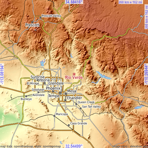
| \ | Map #1 | Topo.Map |
| Scale [m] | 440..614 m | × |
| Scale [ft] | 1444..2014 ft | × |
| Average | 510.7 m = 1676 ft | × |
| Width | 8.13 km = 5.1 mi | 260.1 km = 161.6 mi |
| Height | 8.13 km = 5.1 mi | 260.1 km = 161.6 mi |
| ↑Max Latitude | 33.759083° | 34.88416° |
| Latitude at center | 33.72254° | 33.72254° |
| ↓Min Latitude | 33.685981° | 32.54499° |
| ← Min Longitude | -111.719635° | -113.08194° |
| Longitude center | -111.67569° | -111.67569° |
| →Max Longitude | -111.631745° | -110.26944° |
Nearby cities:
Cities around Rio Verde sort by population:
• Mesa elevation 380 m
36.1 km,  202°
202°
• Gilbert 377 m
42.4 km,  194°
194°
• Scottsdale 382 m
31.5 km,  221°
221°
• Tempe 360 m
40.5 km,  212°
212°
• Deer Valley 416 m
42.7 km,  264°
264°
• Tempe Junction 352 m
42.3 km, 215°
• Apache Junction 526 m
36.1 km,  161°
161°
• Fountain Hills 494 m
12.9 km, 197°
• Paradise Valley 411 m
32.6 km,  229°
229°
• Cave Creek 649 m
28.3 km,  295°
295°
• Carefree 729 m
25 km, 296°
• Tonto Basin 683 m
37.3 km,  70°
70°
Multilingual:
 En español:
Rio Verde elevación 494 m.
 En France:
Rio Verde élévation 494 m.
 Auf Deutsch:
Rio Verde höhe über dem Meeresspiegel ist 494 m.

Sources and notes:
- [note 1] Map square and city borders are not equal. Map elevation data is calculated only from area inside that square.
- [src 1] Elevation data from geonames database provided with same terms of usage.
- [src 2] The elevation map of Rio Verde is generated using elevation data from NASA's 3 arcsec (90m) resolution SRTM data.
- [src 3] Base (background) map © OpenStreetMap contributors tiles are generated by Geofabrik and OpenTopoMap.
Copyright & License:
This Rio Verde Elevation Map is licensed under CC BY-SA. You may reuse any part from this page, if you give a proper credit by linking to this URL:
 More info on terms of use page.