Vega elevation
Vega (Texas, Oldham County), United States elevation is 1236 meters and Vega elevation in feet is 4055 ft above sea level [src 1]. Vega is a seat of a second-order administrative division (feature code) with elevation that is 957 meters (3140 ft) bigger than average city elevation in United States.
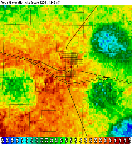
Below is the Elevation map of Vega, which displays elevation range with different colors. Scale of the first map is from 1204 to 1248 m (3950 to 4094 ft) with average elevation of 1229.8 meters (=4035 ft) [note 1]
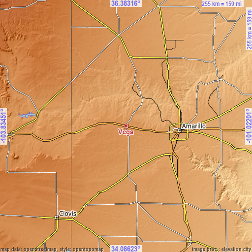
These maps also provides idea of topography and contour of this city, they are displayed at different zoom levels. More info about maps, scale and edge coordinates you can find below images.
| \ | Map #1 | Topo.Map |
| Scale [m] | 1204..1248 m | × |
| Scale [ft] | 3950..4094 ft | × |
| Average | 1229.8 m = 4035 ft | × |
| Width | 7.98 km = 5 mi | 255.4 km = 158.7 mi |
| Height | 7.98 km = 5 mi | 255.4 km = 158.7 mi |
| ↑Max Latitude | 35.278713° | 36.38316° |
| Latitude at center | 35.24283° | 35.24283° |
| ↓Min Latitude | 35.206931° | 34.08623° |
| ← Min Longitude | -102.472205° | -103.83451° |
| Longitude center | -102.42826° | -102.42826° |
| →Max Longitude | -102.384315° | -101.02201° |
Nearby cities:
Cities around Vega sort by population:
• Amarillo elevation 1124 m
54.3 km,  92°
92°
• Hereford 1171 m
47.6 km,  176°
176°
• Dumas 1118 m
80.6 km,  30°
30°
• Canyon 1086 m
54.8 km,  122°
122°
• Dalhart 1215 m
91.1 km,  355°
355°
• Dimmitt 1188 m
77.7 km,  172°
172°
• Friona 1232 m
72.1 km,  201°
201°
• Panhandle 1057 m
95.8 km,  83°
83°
• Fritch 980 m
86.8 km,  59°
59°
• Bovina 1242 m
91.1 km,  207°
207°
• Bushland 1177 m
33.5 km,  99°
99°
• Channing 1161 m
49.8 km,  10°
10°
Multilingual:
 En español:
Vega elevación 1236 m.
 En France:
Vega élévation 1236 m.


Sources and notes:
- [note 1] Map square and city borders are not equal. Map elevation data is calculated only from area inside that square.
- [src 1] Elevation data from geonames database provided with same terms of usage.
- [src 2] The elevation map of Vega is generated using elevation data from NASA's 3 arcsec (90m) resolution SRTM data.
- [src 3] Base (background) map © OpenStreetMap contributors tiles are generated by Geofabrik and OpenTopoMap.
Copyright & License:
This Vega Elevation Map is licensed under CC BY-SA. You may reuse any part from this page, if you give a proper credit by linking to this URL:
 More info on terms of use page.