Bushland elevation
Bushland (Texas, Potter County), United States elevation is 1177 meters and Bushland elevation in feet is 3862 ft above sea level [src 1]. Bushland is a populated place (feature code) with elevation that is 898 meters (2946 ft) bigger than average city elevation in United States.
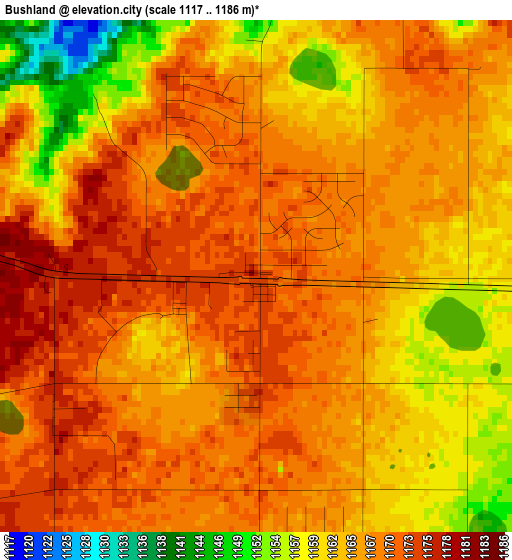
Below is the Elevation map of Bushland, which displays elevation range with different colors. Scale of the first map is from 1117 to 1186 m (3665 to 3891 ft) with average elevation of 1166.1 meters (=3826 ft) [note 1]
These maps also provides idea of topography and contour of this city, they are displayed at different zoom levels. More info about maps, scale and edge coordinates you can find below images.
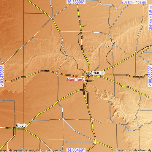
| \ | Map #1 | Topo.Map |
| Scale [m] | 1117..1186 m | × |
| Scale [ft] | 3665..3891 ft | × |
| Average | 1166.1 m = 3826 ft | × |
| Width | 7.99 km = 5 mi | 255.6 km = 158.8 mi |
| Height | 7.99 km = 5 mi | 255.6 km = 158.8 mi |
| ↑Max Latitude | 35.227905° | 36.33306° |
| Latitude at center | 35.192° | 35.192° |
| ↓Min Latitude | 35.156079° | 34.03469° |
| ← Min Longitude | -102.108585° | -103.47089° |
| Longitude center | -102.06464° | -102.06464° |
| →Max Longitude | -102.020695° | -100.65839° |
Nearby cities:
Cities around Bushland sort by population:
• Amarillo elevation 1124 m
21.5 km,  81°
81°
• Hereford 1171 m
51.8 km,  216°
216°
• Dumas 1118 m
75.4 km,  6°
6°
• Canyon 1086 m
27 km,  150°
150°
• Borger 944 m
80.3 km,  48°
48°
• Tulia 1064 m
78.1 km,  159°
159°
• Dimmitt 1188 m
74.8 km,  197°
197°
• Panhandle 1057 m
64.4 km,  74°
74°
• Fritch 980 m
65 km,  40°
40°
• Claude 1039 m
64.4 km,  97°
97°
• Vega 1236 m
33.5 km,  279°
279°
• Channing 1161 m
59.7 km,  336°
336°
Multilingual:
 En español:
Bushland elevación 1177 m.
 En France:
Bushland élévation 1177 m.
 Auf Deutsch:
Bushland höhe über dem Meeresspiegel ist 1177 m.

Sources and notes:
- [note 1] Map square and city borders are not equal. Map elevation data is calculated only from area inside that square.
- [src 1] Elevation data from geonames database provided with same terms of usage.
- [src 2] The elevation map of Bushland is generated using elevation data from NASA's 3 arcsec (90m) resolution SRTM data.
- [src 3] Base (background) map © OpenStreetMap contributors tiles are generated by Geofabrik and OpenTopoMap.
Copyright & License:
This Bushland Elevation Map is licensed under CC BY-SA. You may reuse any part from this page, if you give a proper credit by linking to this URL:
 More info on terms of use page.