Aspermont elevation
Aspermont (Texas, Stonewall County), United States elevation is 545 meters and Aspermont elevation in feet is 1788 ft above sea level [src 1]. Aspermont is a seat of a second-order administrative division (feature code) with elevation that is 266 meters (873 ft) bigger than average city elevation in United States.
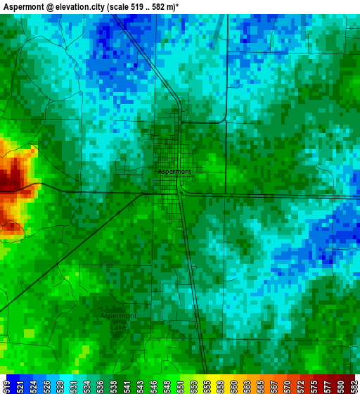
Below is the Elevation map of Aspermont, which displays elevation range with different colors. Scale of the first map is from 519 to 582 m (1703 to 1909 ft) with average elevation of 537.2 meters (=1762 ft) [note 1]
These maps also provides idea of topography and contour of this city, they are displayed at different zoom levels. More info about maps, scale and edge coordinates you can find below images.
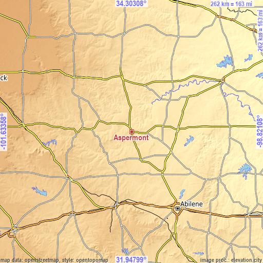
| \ | Map #1 | Topo.Map |
| Scale [m] | 519..582 m | × |
| Scale [ft] | 1703..1909 ft | × |
| Average | 537.2 m = 1762 ft | × |
| Width | 8.18 km = 5.1 mi | 261.9 km = 162.7 mi |
| Height | 8.18 km = 5.1 mi | 261.9 km = 162.7 mi |
| ↑Max Latitude | 33.170222° | 34.30308° |
| Latitude at center | 33.13343° | 33.13343° |
| ↓Min Latitude | 33.096622° | 31.94799° |
| ← Min Longitude | -100.271275° | -101.63358° |
| Longitude center | -100.22733° | -100.22733° |
| →Max Longitude | -100.183385° | -98.82108° |
Nearby cities:
Cities around Aspermont sort by population:
• Haskell elevation 483 m
46 km,  86°
86°
• Stamford 497 m
44.7 km,  117°
117°
• Anson 532 m
52.1 km,  143°
143°
• Hamlin 524 m
29.2 km,  161°
161°
• Rotan 595 m
38.4 km,  215°
215°
• Munday 455 m
66.3 km,  57°
57°
• Spur 701 m
69.7 km,  303°
303°
• Knox City 467 m
49.4 km,  50°
50°
• Roby 600 m
45.4 km,  197°
197°
• Jayton 613 m
34.7 km,  291°
291°
• Benjamin 452 m
64.4 km,  38°
38°
• Guthrie 533 m
54.9 km,  350°
350°
Multilingual:
 En español:
Aspermont elevación 545 m.
 En France:
Aspermont élévation 545 m.
 Auf Deutsch:
Aspermont höhe über dem Meeresspiegel ist 545 m.

Sources and notes:
- [note 1] Map square and city borders are not equal. Map elevation data is calculated only from area inside that square.
- [src 1] Elevation data from geonames database provided with same terms of usage.
- [src 2] The elevation map of Aspermont is generated using elevation data from NASA's 3 arcsec (90m) resolution SRTM data.
- [src 3] Base (background) map © OpenStreetMap contributors tiles are generated by Geofabrik and OpenTopoMap.
Copyright & License:
This Aspermont Elevation Map is licensed under CC BY-SA. You may reuse any part from this page, if you give a proper credit by linking to this URL:
 More info on terms of use page.