Guthrie elevation
Guthrie (Texas, King County), United States elevation is 533 meters and Guthrie elevation in feet is 1749 ft above sea level [src 1]. Guthrie is a seat of a second-order administrative division (feature code) with elevation that is 254 meters (833 ft) bigger than average city elevation in United States.
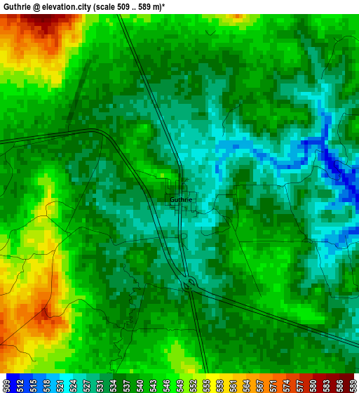
Below is the Elevation map of Guthrie, which displays elevation range with different colors. Scale of the first map is from 509 to 589 m (1670 to 1932 ft) with average elevation of 538.6 meters (=1767 ft) [note 1]
These maps also provides idea of topography and contour of this city, they are displayed at different zoom levels. More info about maps, scale and edge coordinates you can find below images.
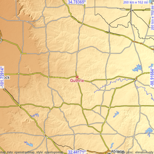
| \ | Map #1 | Topo.Map |
| Scale [m] | 509..589 m | × |
| Scale [ft] | 1670..1932 ft | × |
| Average | 538.6 m = 1767 ft | × |
| Width | 8.14 km = 5.1 mi | 260.4 km = 161.8 mi |
| Height | 8.14 km = 5.1 mi | 260.4 km = 161.8 mi |
| ↑Max Latitude | 33.657226° | 34.78365° |
| Latitude at center | 33.62064° | 33.62064° |
| ↓Min Latitude | 33.584038° | 32.44171° |
| ← Min Longitude | -100.366835° | -101.72914° |
| Longitude center | -100.32289° | -100.32289° |
| →Max Longitude | -100.278945° | -98.91664° |
Nearby cities:
Cities around Guthrie sort by population:
• Haskell elevation 483 m
75.1 km,  133°
133°
• Hamlin 524 m
83.8 km,  167°
167°
• Munday 455 m
67.6 km,  106°
106°
• Spur 701 m
51.9 km,  252°
252°
• Knox City 467 m
51.9 km,  115°
115°
• Paducah 568 m
43.6 km,  2°
2°
• Aspermont 545 m
54.9 km, 170°
• Crowell 456 m
68.5 km,  53°
53°
• Matador 730 m
63.4 km,  313°
313°
• Jayton 613 m
47.5 km,  209°
209°
• Benjamin 452 m
49.3 km,  94°
94°
• Dickens 775 m
47.6 km,  270°
270°
Multilingual:
 En español:
Guthrie elevación 533 m.
 En France:
Guthrie élévation 533 m.


Sources and notes:
- [note 1] Map square and city borders are not equal. Map elevation data is calculated only from area inside that square.
- [src 1] Elevation data from geonames database provided with same terms of usage.
- [src 2] The elevation map of Guthrie is generated using elevation data from NASA's 3 arcsec (90m) resolution SRTM data.
- [src 3] Base (background) map © OpenStreetMap contributors tiles are generated by Geofabrik and OpenTopoMap.
Copyright & License:
This Guthrie Elevation Map is licensed under CC BY-SA. You may reuse any part from this page, if you give a proper credit by linking to this URL:
 More info on terms of use page.