Moapa Valley elevation
Moapa Valley (Nevada, Clark County), United States elevation is 410 meters and Moapa Valley elevation in feet is 1345 ft above sea level [src 1]. Moapa Valley is a populated place (feature code) with elevation that is 131 meters (430 ft) bigger than average city elevation in United States.
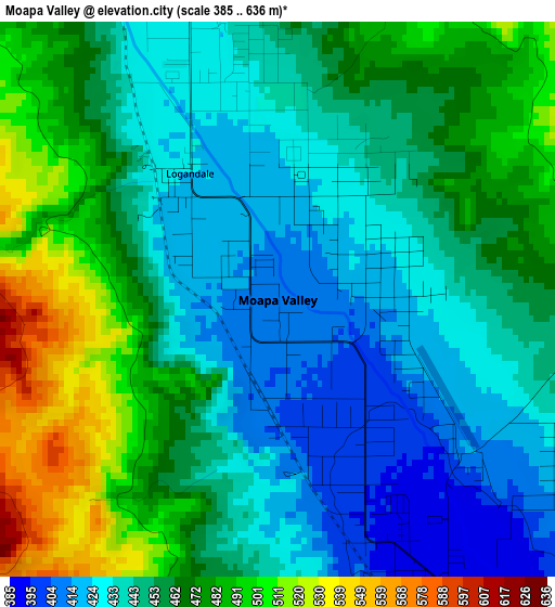
Below is the Elevation map of Moapa Valley, which displays elevation range with different colors. Scale of the first map is from 385 to 636 m (1263 to 2087 ft) with average elevation of 455.5 meters (=1494 ft) [note 1]
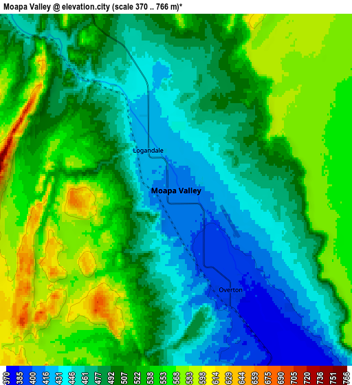
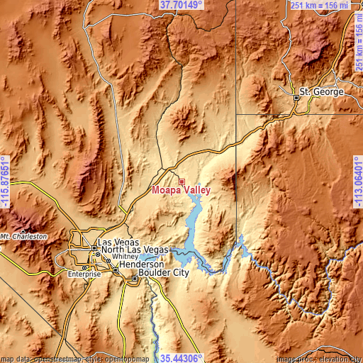
These maps also provides idea of topography and contour of this city, they are displayed at different zoom levels. More info about maps, scale and edge coordinates you can find below images.
| \ | Map #1 | Map #2 | Topo.Map |
| Scale [m] | 385..636 m | 370..766 m | × |
| Scale [ft] | 1263..2087 ft | 1214..2513 ft | × |
| Average | 455.5 m = 1494 ft | 504.2 m = 1654 ft | × |
| Width | 7.85 km = 4.9 mi | 15.7 km = 9.8 mi | 251.1 km = 156 mi |
| Height | 7.85 km = 4.9 mi | 15.7 km = 9.8 mi | 251.1 km = 156 mi |
| ↑Max Latitude | 36.615811° | 36.651076° | 37.70149° |
| Latitude at center | 36.58053° | 36.58053° | 36.58053° |
| ↓Min Latitude | 36.545233° | 36.50992° | 35.44306° |
| ← Min Longitude | -114.514205° | -114.558151° | -115.87651° |
| Longitude center | -114.47026° | -114.47026° | -114.47026° |
| →Max Longitude | -114.426315° | -114.382369° | -113.06401° |
Nearby cities:
Cities around Moapa Valley sort by population:
• Las Vegas elevation 613 m
74.8 km,  232°
232°
• North Las Vegas 570 m
71.8 km, 233°
• Sunrise Manor 561 m
67.8 km, 232°
• Whitney 506 m
73.8 km,  223°
223°
• Mesquite 493 m
43.8 km,  55°
55°
• Boulder City 768 m
74.4 km,  205°
205°
• Nellis Air Force Base 577 m
64.4 km, 234°
• Beaver Dam 559 m
59.6 km,  53°
53°
• Scenic 550 m
47.2 km, 59°
• Bunkerville 468 m
37.3 km, 54°
• Meadview 913 m
73.7 km,  150°
150°
• Moapa Town 491 m
15.8 km,  315°
315°
Multilingual:
 En español:
Moapa Valley elevación 410 m.
 En France:
Moapa Valley élévation 410 m.
 Auf Deutsch:
Moapa Valley höhe über dem Meeresspiegel ist 410 m.

Sources and notes:
- [note 1] Map square and city borders are not equal. Map elevation data is calculated only from area inside that square.
- [src 1] Elevation data from geonames database provided with same terms of usage.
- [src 2] The elevation map of Moapa Valley is generated using elevation data from NASA's 3 arcsec (90m) resolution SRTM data.
- [src 3] Base (background) map © OpenStreetMap contributors tiles are generated by Geofabrik and OpenTopoMap.
Copyright & License:
This Moapa Valley Elevation Map is licensed under CC BY-SA. You may reuse any part from this page, if you give a proper credit by linking to this URL:
 More info on terms of use page.