Meadview elevation
Meadview (Arizona, Mohave County), United States elevation is 913 meters and Meadview elevation in feet is 2995 ft above sea level [src 1]. Meadview is a populated place (feature code) with elevation that is 634 meters (2080 ft) bigger than average city elevation in United States.
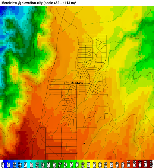
Below is the Elevation map of Meadview, which displays elevation range with different colors. Scale of the first map is from 462 to 1113 m (1516 to 3652 ft) with average elevation of 869.9 meters (=2854 ft) [note 1]
These maps also provides idea of topography and contour of this city, they are displayed at different zoom levels. More info about maps, scale and edge coordinates you can find below images.
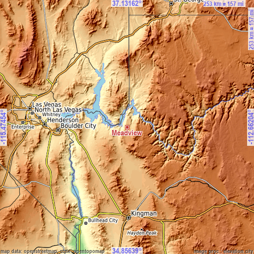
| \ | Map #1 | Topo.Map |
| Scale [m] | 462..1113 m | × |
| Scale [ft] | 1516..3652 ft | × |
| Average | 869.9 m = 2854 ft | × |
| Width | 7.91 km = 4.9 mi | 253 km = 157.2 mi |
| Height | 7.91 km = 4.9 mi | 253 km = 157.2 mi |
| ↑Max Latitude | 36.037753° | 37.13162° |
| Latitude at center | 36.00221° | 36.00221° |
| ↓Min Latitude | 35.96665° | 34.85639° |
| ← Min Longitude | -114.112235° | -115.47454° |
| Longitude center | -114.06829° | -114.06829° |
| →Max Longitude | -114.024345° | -112.66204° |
Nearby cities:
Cities around Meadview sort by population:
• Henderson elevation 572 m
82.3 km,  272°
272°
• Whitney 506 m
87.7 km,  277°
277°
• Boulder City 768 m
68.8 km, 267°
• New Kingman-Butler 1047 m
82 km,  177°
177°
• Golden Valley 857 m
87.7 km,  189°
189°
• Moapa Valley 410 m
73.7 km,  330°
330°
• Dolan Springs 1030 m
49.2 km,  202°
202°
• Valle Vista 969 m
68.3 km,  164°
164°
• Scenic 550 m
88.1 km,  3°
3°
• Bunkerville 468 m
85.9 km,  356°
356°
• Peach Springs 1466 m
78.3 km,  132°
132°
• Moapa Town 491 m
89.1 km, 328°
Multilingual:
 En español:
Meadview elevación 913 m.
 En France:
Meadview élévation 913 m.
 Auf Deutsch:
Meadview höhe über dem Meeresspiegel ist 913 m.

Sources and notes:
- [note 1] Map square and city borders are not equal. Map elevation data is calculated only from area inside that square.
- [src 1] Elevation data from geonames database provided with same terms of usage.
- [src 2] The elevation map of Meadview is generated using elevation data from NASA's 3 arcsec (90m) resolution SRTM data.
- [src 3] Base (background) map © OpenStreetMap contributors tiles are generated by Geofabrik and OpenTopoMap.
Copyright & License:
This Meadview Elevation Map is licensed under CC BY-SA. You may reuse any part from this page, if you give a proper credit by linking to this URL:
 More info on terms of use page.