Henderson elevation
Henderson (Nevada, Clark County), United States elevation is 572 meters and Henderson elevation in feet is 1877 ft above sea level [src 1]. Henderson is a populated place (feature code) with elevation that is 293 meters (961 ft) bigger than average city elevation in United States.
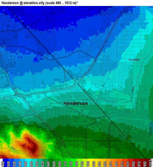
Below is the Elevation map of Henderson, which displays elevation range with different colors. Scale of the first map is from 488 to 1012 m (1601 to 3320 ft) with average elevation of 594.4 meters (=1950 ft) [note 1]
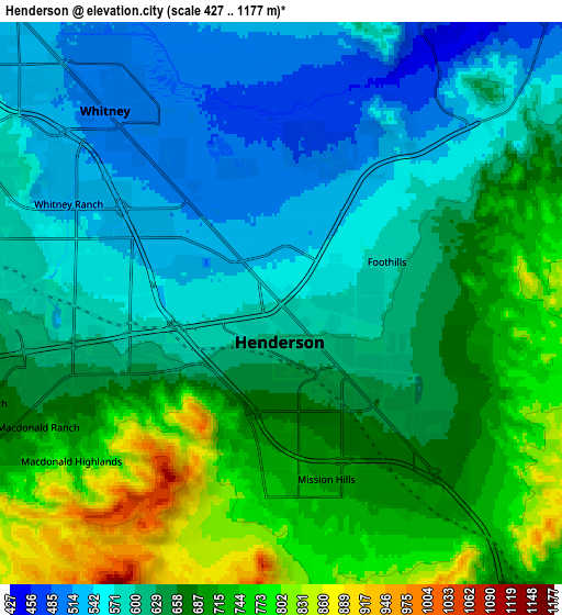
These maps also provides idea of topography and contour of this city, they are displayed at different zoom levels. More info about maps, scale and edge coordinates you can find below images.
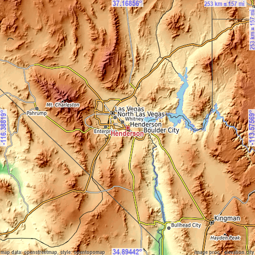
| \ | Map #1 | Map #2 | Topo.Map |
| Scale [m] | 488..1012 m | 427..1177 m | × |
| Scale [ft] | 1601..3320 ft | 1401..3862 ft | × |
| Average | 594.4 m = 1950 ft | 643.3 m = 2111 ft | × |
| Width | 7.9 km = 4.9 mi | 15.8 km = 9.8 mi | 252.9 km = 157.1 mi |
| Height | 7.9 km = 4.9 mi | 15.8 km = 9.8 mi | 252.9 km = 157.1 mi |
| ↑Max Latitude | 36.075227° | 36.110737° | 37.16856° |
| Latitude at center | 36.0397° | 36.0397° | 36.0397° |
| ↓Min Latitude | 36.004157° | 35.968599° | 34.89442° |
| ← Min Longitude | -115.025885° | -115.069831° | -116.38819° |
| Longitude center | -114.98194° | -114.98194° | -114.98194° |
| →Max Longitude | -114.937995° | -114.894049° | -113.57569° |
Nearby cities:
Cities around Henderson sort by population:
• Las Vegas elevation 613 m
20.5 km,  317°
317°
• North Las Vegas 570 m
21.5 km,  325°
325°
• Paradise 629 m
16.1 km,  293°
293°
• Sunrise Manor 561 m
20.7 km,  336°
336°
• Spring Valley 723 m
24.8 km, 287°
• Enterprise 779 m
23.4 km,  266°
266°
• Whitney 506 m
8.1 km, 323°
• Winchester 589 m
15.9 km,  309°
309°
• Summerlin South 872 m
32.4 km, 285°
• Boulder City 768 m
15.1 km,  116°
116°
• Nellis Air Force Base 577 m
23.9 km, 343°
• Sandy Valley 806 m
63.6 km,  247°
247°
Multilingual:
 En español:
Henderson elevación 572 m.
 En France:
Henderson élévation 572 m.
 Auf Deutsch:
Henderson höhe über dem Meeresspiegel ist 572 m.

Sources and notes:
- [note 1] Map square and city borders are not equal. Map elevation data is calculated only from area inside that square.
- [src 1] Elevation data from geonames database provided with same terms of usage.
- [src 2] The elevation map of Henderson is generated using elevation data from NASA's 3 arcsec (90m) resolution SRTM data.
- [src 3] Base (background) map © OpenStreetMap contributors tiles are generated by Geofabrik and OpenTopoMap.
Copyright & License:
This Henderson Elevation Map is licensed under CC BY-SA. You may reuse any part from this page, if you give a proper credit by linking to this URL:
 More info on terms of use page.