Eureka elevation
Eureka (Nevada, Eureka County), United States elevation is 1979 meters and Eureka elevation in feet is 6493 ft above sea level [src 1]. Eureka is a seat of a second-order administrative division (feature code) with elevation that is 1700 meters (5577 ft) bigger than average city elevation in United States.
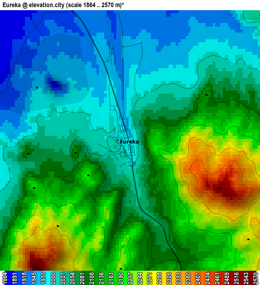
Below is the Elevation map of Eureka, which displays elevation range with different colors. Scale of the first map is from 1864 to 2570 m (6115 to 8432 ft) with average elevation of 2089.3 meters (=6855 ft) [note 1]
These maps also provides idea of topography and contour of this city, they are displayed at different zoom levels. More info about maps, scale and edge coordinates you can find below images.
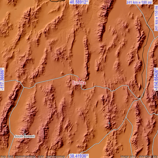
| \ | Map #1 | Topo.Map |
| Scale [m] | 1864..2570 m | × |
| Scale [ft] | 6115..8432 ft | × |
| Average | 2089.3 m = 6855 ft | × |
| Width | 7.54 km = 4.7 mi | 241.3 km = 149.9 mi |
| Height | 7.54 km = 4.7 mi | 241.2 km = 149.9 mi |
| ↑Max Latitude | 39.546605° | 40.58912° |
| Latitude at center | 39.51271° | 39.51271° |
| ↓Min Latitude | 39.478799° | 38.41936° |
| ← Min Longitude | -116.004555° | -117.36686° |
| Longitude center | -115.96061° | -115.96061° |
| →Max Longitude | -115.916665° | -114.55436° |
Nearby cities:
Cities around Eureka sort by population:
• Elko elevation 1551 m
147.7 km,  6°
6°
• Spring Creek 1725 m
138.7 km, 13°
• Winnemucca 1316 m
221.5 km,  317°
317°
• West Wendover 1361 m
210.6 km,  49°
49°
• Ely 1968 m
96.7 km,  107°
107°
• Battle Mountain 1381 m
150.4 km,  326°
326°
• Tonopah 1847 m
194.8 km,  214°
214°
• Carlin 1496 m
134.1 km,  354°
354°
• Wendover 1312 m
212.8 km, 50°
• Wells 1720 m
196.8 km,  25°
25°
• McGill 1899 m
102.2 km,  96°
96°
• Pioche 1863 m
219.3 km,  143°
143°
Multilingual:
 En español:
Eureka elevación 1979 m.
 En France:
Eureka élévation 1979 m.


Sources and notes:
- [note 1] Map square and city borders are not equal. Map elevation data is calculated only from area inside that square.
- [src 1] Elevation data from geonames database provided with same terms of usage.
- [src 2] The elevation map of Eureka is generated using elevation data from NASA's 3 arcsec (90m) resolution SRTM data.
- [src 3] Base (background) map © OpenStreetMap contributors tiles are generated by Geofabrik and OpenTopoMap.
Copyright & License:
This Eureka Elevation Map is licensed under CC BY-SA. You may reuse any part from this page, if you give a proper credit by linking to this URL:
 More info on terms of use page.