Dayton elevation
Dayton (Nevada, Lyon County), United States elevation is 1335 meters and Dayton elevation in feet is 4380 ft above sea level [src 1]. Dayton is a populated place (feature code) with elevation that is 1056 meters (3465 ft) bigger than average city elevation in United States.
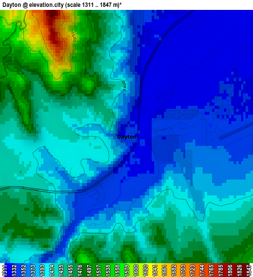
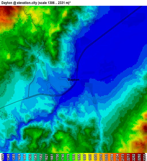
Below is the Elevation map of Dayton, which displays elevation range with different colors. Scale of the first map is from 1311 to 1847 m (4301 to 6060 ft) with average elevation of 1409.7 meters (=4625 ft) [note 1]
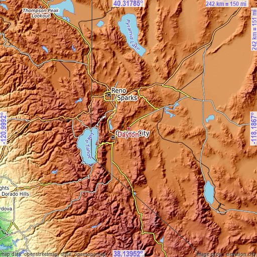
These maps also provides idea of topography and contour of this city, they are displayed at different zoom levels. More info about maps, scale and edge coordinates you can find below images.
| \ | Map #1 | Map #2 | Topo.Map |
| Scale [m] | 1311..1847 m | 1306..2331 m | × |
| Scale [ft] | 4301..6060 ft | 4285..7648 ft | × |
| Average | 1409.7 m = 4625 ft | 1531.2 m = 5024 ft | × |
| Width | 7.57 km = 4.7 mi | 15.14 km = 9.4 mi | 242.2 km = 150.5 mi |
| Height | 7.57 km = 4.7 mi | 15.14 km = 9.4 mi | 242.2 km = 150.5 mi |
| ↑Max Latitude | 39.271169° | 39.305181° | 40.31785° |
| Latitude at center | 39.23714° | 39.23714° | 39.23714° |
| ↓Min Latitude | 39.203095° | 39.169033° | 38.13952° |
| ← Min Longitude | -119.636895° | -119.680841° | -120.9992° |
| Longitude center | -119.59295° | -119.59295° | -119.59295° |
| →Max Longitude | -119.549005° | -119.505059° | -118.1867° |
Nearby cities:
Cities around Dayton sort by population:
• Sparks elevation 1348 m
35.8 km,  337°
337°
• Carson City 1431 m
17.1 km,  241°
241°
• Incline Village 1966 m
32.8 km,  272°
272°
• Johnson Lane 1467 m
23.8 km,  207°
207°
• Gardnerville 1452 m
35.6 km,  202°
202°
• Indian Hills 1456 m
23.5 km,  224°
224°
• Silver Springs 1283 m
37.4 km,  57°
57°
• Kings Beach 1909 m
37.3 km, 270°
• Minden 1449 m
34.8 km, 205°
• Stagecoach 1326 m
24.2 km,  51°
51°
• East Valley 1499 m
33.9 km, 195°
• Virginia City 1897 m
9.4 km,  328°
328°
Multilingual:
 En español:
Dayton elevación 1335 m.
 En France:
Dayton élévation 1335 m.


Sources and notes:
- [note 1] Map square and city borders are not equal. Map elevation data is calculated only from area inside that square.
- [src 1] Elevation data from geonames database provided with same terms of usage.
- [src 2] The elevation map of Dayton is generated using elevation data from NASA's 3 arcsec (90m) resolution SRTM data.
- [src 3] Base (background) map © OpenStreetMap contributors tiles are generated by Geofabrik and OpenTopoMap.
Copyright & License:
This Dayton Elevation Map is licensed under CC BY-SA. You may reuse any part from this page, if you give a proper credit by linking to this URL:
 More info on terms of use page.