Johnson Lane elevation
Johnson Lane (Nevada, Douglas County), United States elevation is 1467 meters and Johnson Lane elevation in feet is 4813 ft above sea level [src 1]. Johnson Lane is a populated place (feature code) with elevation that is 1188 meters (3898 ft) bigger than average city elevation in United States.
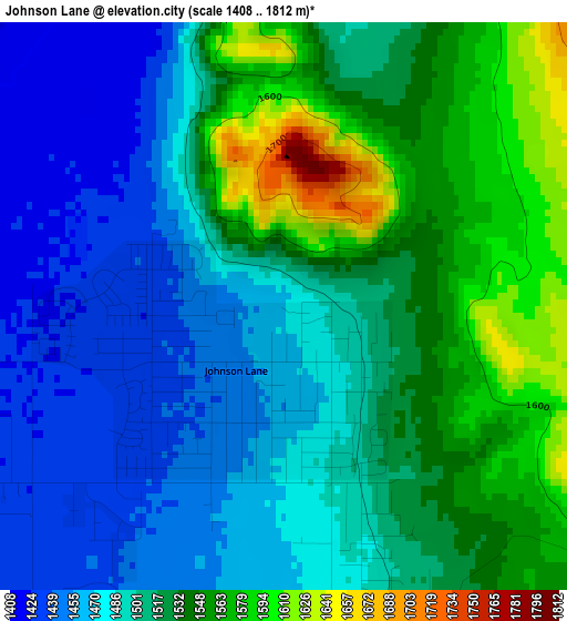
Below is the Elevation map of Johnson Lane, which displays elevation range with different colors. Scale of the first map is from 1408 to 1812 m (4619 to 5945 ft) with average elevation of 1509.7 meters (=4953 ft) [note 1]
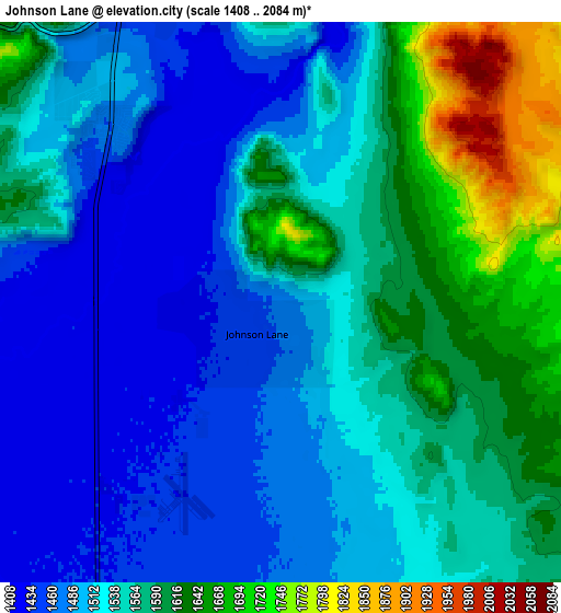
These maps also provides idea of topography and contour of this city, they are displayed at different zoom levels. More info about maps, scale and edge coordinates you can find below images.
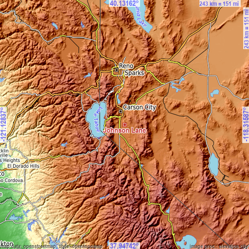
| \ | Map #1 | Map #2 | Topo.Map |
| Scale [m] | 1408..1812 m | 1408..2084 m | × |
| Scale [ft] | 4619..5945 ft | 4619..6837 ft | × |
| Average | 1509.7 m = 4953 ft | 1543.8 m = 5065 ft | × |
| Width | 7.59 km = 4.7 mi | 15.18 km = 9.4 mi | 242.9 km = 150.9 mi |
| Height | 7.59 km = 4.7 mi | 15.18 km = 9.4 mi | 242.9 km = 150.9 mi |
| ↑Max Latitude | 39.082081° | 39.116185° | 40.13162° |
| Latitude at center | 39.04796° | 39.04796° | 39.04796° |
| ↓Min Latitude | 39.013823° | 38.97967° | 37.94742° |
| ← Min Longitude | -119.766065° | -119.810011° | -121.12837° |
| Longitude center | -119.72212° | -119.72212° | -119.72212° |
| →Max Longitude | -119.678175° | -119.634229° | -118.31587° |
Nearby cities:
Cities around Johnson Lane sort by population:
• Carson City elevation 1431 m
13.5 km,  343°
343°
• South Lake Tahoe 1902 m
26 km,  240°
240°
• Gardnerville Ranchos 1487 m
17.8 km,  185°
185°
• Dayton 1335 m
23.8 km,  27°
27°
• Incline Village 1966 m
31.3 km,  316°
316°
• Gardnerville 1452 m
12.1 km, 191°
• Indian Hills 1456 m
6.8 km,  308°
308°
• Kings Beach 1909 m
33.7 km, 308°
• Minden 1449 m
11.1 km,  199°
199°
• Kingsbury 2193 m
17.8 km, 243°
• East Valley 1499 m
11.8 km,  170°
170°
• Virginia City 1897 m
29.8 km,  12°
12°
Multilingual:
 En español:
Johnson Lane elevación 1467 m.
 En France:
Johnson Lane élévation 1467 m.
 Auf Deutsch:
Johnson Lane höhe über dem Meeresspiegel ist 1467 m.

Sources and notes:
- [note 1] Map square and city borders are not equal. Map elevation data is calculated only from area inside that square.
- [src 1] Elevation data from geonames database provided with same terms of usage.
- [src 2] The elevation map of Johnson Lane is generated using elevation data from NASA's 3 arcsec (90m) resolution SRTM data.
- [src 3] Base (background) map © OpenStreetMap contributors tiles are generated by Geofabrik and OpenTopoMap.
Copyright & License:
This Johnson Lane Elevation Map is licensed under CC BY-SA. You may reuse any part from this page, if you give a proper credit by linking to this URL:
 More info on terms of use page.