Silver Springs elevation
Silver Springs (Nevada, Lyon County), United States elevation is 1283 meters and Silver Springs elevation in feet is 4209 ft above sea level [src 1]. Silver Springs is a populated place (feature code) with elevation that is 1004 meters (3294 ft) bigger than average city elevation in United States.
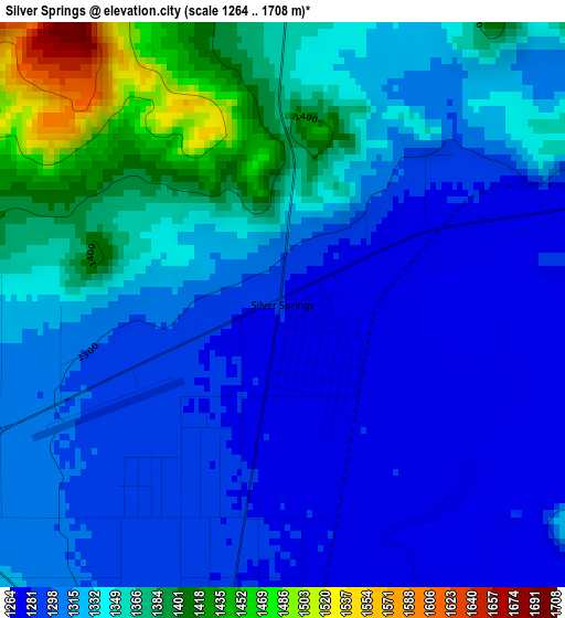
Below is the Elevation map of Silver Springs, which displays elevation range with different colors. Scale of the first map is from 1264 to 1708 m (4147 to 5604 ft) with average elevation of 1327.6 meters (=4356 ft) [note 1]
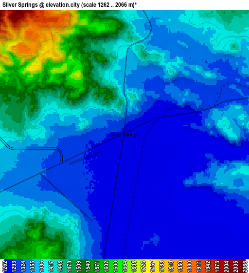
These maps also provides idea of topography and contour of this city, they are displayed at different zoom levels. More info about maps, scale and edge coordinates you can find below images.
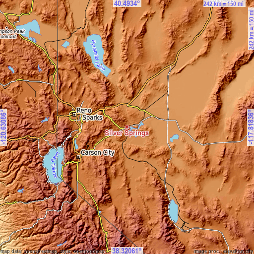
| \ | Map #1 | Map #2 | Topo.Map |
| Scale [m] | 1264..1708 m | 1262..2066 m | × |
| Scale [ft] | 4147..5604 ft | 4140..6778 ft | × |
| Average | 1327.6 m = 4356 ft | 1391 m = 4564 ft | × |
| Width | 7.55 km = 4.7 mi | 15.1 km = 9.4 mi | 241.6 km = 150.1 mi |
| Height | 7.55 km = 4.7 mi | 15.1 km = 9.4 mi | 241.6 km = 150.1 mi |
| ↑Max Latitude | 39.449412° | 39.483338° | 40.4934° |
| Latitude at center | 39.41547° | 39.41547° | 39.41547° |
| ↓Min Latitude | 39.381511° | 39.347536° | 38.32061° |
| ← Min Longitude | -119.268555° | -119.312501° | -120.63086° |
| Longitude center | -119.22461° | -119.22461° | -119.22461° |
| →Max Longitude | -119.180665° | -119.136719° | -117.81836° |
Nearby cities:
Cities around Silver Springs sort by population:
• Reno elevation 1380 m
52.1 km,  284°
284°
• Sparks 1348 m
47.2 km,  286°
286°
• Carson City 1431 m
54.5 km,  239°
239°
• Fernley 1270 m
21.5 km,  353°
353°
• Sun Valley 1440 m
51.4 km, 293°
• Spanish Springs 1378 m
48.9 km,  302°
302°
• Dayton 1335 m
37.4 km, 237°
• Fallon 1215 m
38.9 km,  80°
80°
• Yerington 1342 m
48.1 km,  173°
173°
• Stagecoach 1326 m
13.7 km,  250°
250°
• Golden Valley 1554 m
56.2 km, 293°
• Virginia City 1897 m
38.4 km, 252°
Multilingual:
 En español:
Silver Springs elevación 1283 m.
 En France:
Silver Springs élévation 1283 m.
 Auf Deutsch:
Silver Springs höhe über dem Meeresspiegel ist 1283 m.

Sources and notes:
- [note 1] Map square and city borders are not equal. Map elevation data is calculated only from area inside that square.
- [src 1] Elevation data from geonames database provided with same terms of usage.
- [src 2] The elevation map of Silver Springs is generated using elevation data from NASA's 3 arcsec (90m) resolution SRTM data.
- [src 3] Base (background) map © OpenStreetMap contributors tiles are generated by Geofabrik and OpenTopoMap.
Copyright & License:
This Silver Springs Elevation Map is licensed under CC BY-SA. You may reuse any part from this page, if you give a proper credit by linking to this URL:
 More info on terms of use page.