San Ysidro elevation
San Ysidro (New Mexico, Doña Ana County), United States elevation is 1190 meters and San Ysidro elevation in feet is 3904 ft above sea level [src 1]. San Ysidro is a populated place (feature code) with elevation that is 911 meters (2989 ft) bigger than average city elevation in United States.
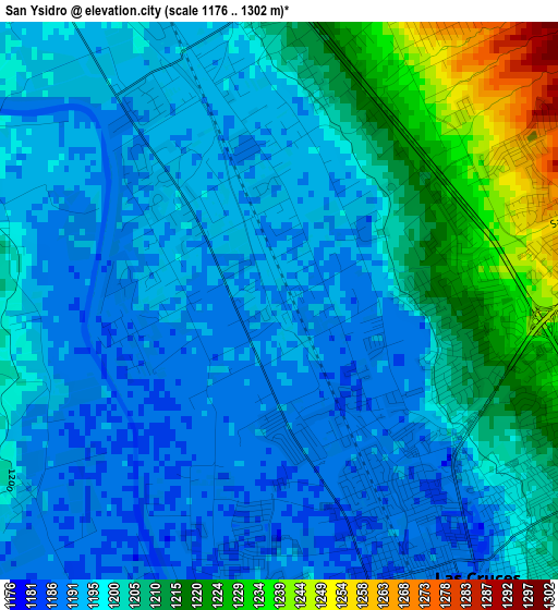
Below is the Elevation map of San Ysidro, which displays elevation range with different colors. Scale of the first map is from 1176 to 1302 m (3858 to 4272 ft) with average elevation of 1200.9 meters (=3940 ft) [note 1]
These maps also provides idea of topography and contour of this city, they are displayed at different zoom levels. More info about maps, scale and edge coordinates you can find below images.
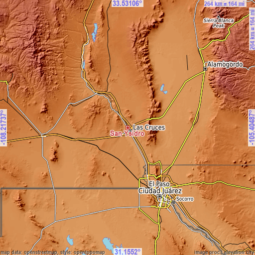
| \ | Map #1 | Topo.Map |
| Scale [m] | 1176..1302 m | × |
| Scale [ft] | 3858..4272 ft | × |
| Average | 1200.9 m = 3940 ft | × |
| Width | 8.26 km = 5.1 mi | 264.2 km = 164.2 mi |
| Height | 8.26 km = 5.1 mi | 264.2 km = 164.2 mi |
| ↑Max Latitude | 32.388047° | 33.53106° |
| Latitude at center | 32.35093° | 32.35093° |
| ↓Min Latitude | 32.313798° | 31.1552° |
| ← Min Longitude | -106.855065° | -108.21737° |
| Longitude center | -106.81112° | -106.81112° |
| →Max Longitude | -106.767175° | -105.40487° |
Nearby cities:
Cities around San Ysidro sort by population:
• Las Cruces elevation 1189 m
5.3 km,  144°
144°
• Anthony 1156 m
43.1 km,  153°
153°
• Anthony 1152 m
43.6 km, 153°
• University Park 1193 m
9.3 km, 144°
• Vado 1161 m
30 km, 152°
• Mesilla 1178 m
9 km,  173°
173°
• Radium Springs 1208 m
20 km,  326°
326°
• White Sands 1294 m
31.3 km,  83°
83°
• Berino 1162 m
35.9 km, 150°
• Doña Ana 1207 m
4.3 km,  356°
356°
• San Miguel 1168 m
22.9 km,  161°
161°
• Mesquite 1169 m
23.4 km, 152°
Multilingual:
 En español:
San Ysidro elevación 1190 m.
 En France:
San Ysidro élévation 1190 m.
 Auf Deutsch:
San Ysidro höhe über dem Meeresspiegel ist 1190 m.

Sources and notes:
- [note 1] Map square and city borders are not equal. Map elevation data is calculated only from area inside that square.
- [src 1] Elevation data from geonames database provided with same terms of usage.
- [src 2] The elevation map of San Ysidro is generated using elevation data from NASA's 3 arcsec (90m) resolution SRTM data.
- [src 3] Base (background) map © OpenStreetMap contributors tiles are generated by Geofabrik and OpenTopoMap.
Copyright & License:
This San Ysidro Elevation Map is licensed under CC BY-SA. You may reuse any part from this page, if you give a proper credit by linking to this URL:
 More info on terms of use page.