Berino elevation
Berino (New Mexico, Doña Ana County), United States elevation is 1162 meters and Berino elevation in feet is 3812 ft above sea level [src 1]. Berino is a populated place (feature code) with elevation that is 883 meters (2897 ft) bigger than average city elevation in United States.
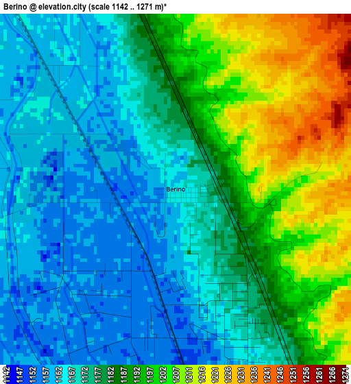
Below is the Elevation map of Berino, which displays elevation range with different colors. Scale of the first map is from 1142 to 1271 m (3747 to 4170 ft) with average elevation of 1181 meters (=3875 ft) [note 1]
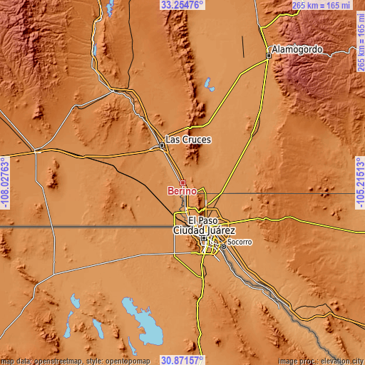
These maps also provides idea of topography and contour of this city, they are displayed at different zoom levels. More info about maps, scale and edge coordinates you can find below images.
| \ | Map #1 | Topo.Map |
| Scale [m] | 1142..1271 m | × |
| Scale [ft] | 3747..4170 ft | × |
| Average | 1181 m = 3875 ft | × |
| Width | 8.28 km = 5.1 mi | 265 km = 164.7 mi |
| Height | 8.28 km = 5.1 mi | 265 km = 164.7 mi |
| ↑Max Latitude | 32.108161° | 33.25476° |
| Latitude at center | 32.07093° | 32.07093° |
| ↓Min Latitude | 32.033684° | 30.87157° |
| ← Min Longitude | -106.665325° | -108.02763° |
| Longitude center | -106.62138° | -106.62138° |
| →Max Longitude | -106.577435° | -105.21513° |
Nearby cities:
Cities around Berino sort by population:
• Chaparral elevation 1236 m
22.8 km,  103°
103°
• Anthony 1156 m
7.6 km,  168°
168°
• Canutillo 1144 m
17.8 km, 173°
• Anthony 1152 m
8.1 km, 169°
• Santa Teresa 1152 m
24 km,  184°
184°
• University Park 1193 m
26.7 km,  332°
332°
• Westway 1200 m
13.1 km,  161°
161°
• Vado 1161 m
6 km,  319°
319°
• Vinton 1152 m
13.4 km, 172°
• San Miguel 1168 m
14.2 km,  311°
311°
• Mesquite 1169 m
12.6 km, 325°
• La Union 1153 m
13.9 km,  195°
195°
Multilingual:
 En español:
Berino elevación 1162 m.
 En France:
Berino élévation 1162 m.


Sources and notes:
- [note 1] Map square and city borders are not equal. Map elevation data is calculated only from area inside that square.
- [src 1] Elevation data from geonames database provided with same terms of usage.
- [src 2] The elevation map of Berino is generated using elevation data from NASA's 3 arcsec (90m) resolution SRTM data.
- [src 3] Base (background) map © OpenStreetMap contributors tiles are generated by Geofabrik and OpenTopoMap.
Copyright & License:
This Berino Elevation Map is licensed under CC BY-SA. You may reuse any part from this page, if you give a proper credit by linking to this URL:
 More info on terms of use page.