Anthony elevation
Anthony (Texas, El Paso County), United States elevation is 1152 meters and Anthony elevation in feet is 3780 ft above sea level [src 1]. Anthony is a populated place (feature code) with elevation that is 873 meters (2864 ft) bigger than average city elevation in United States.
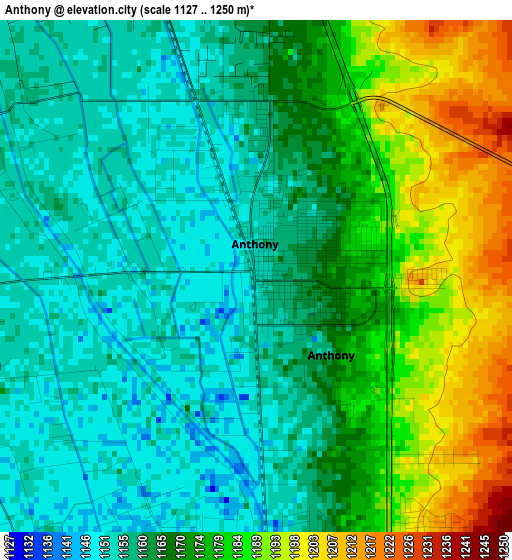
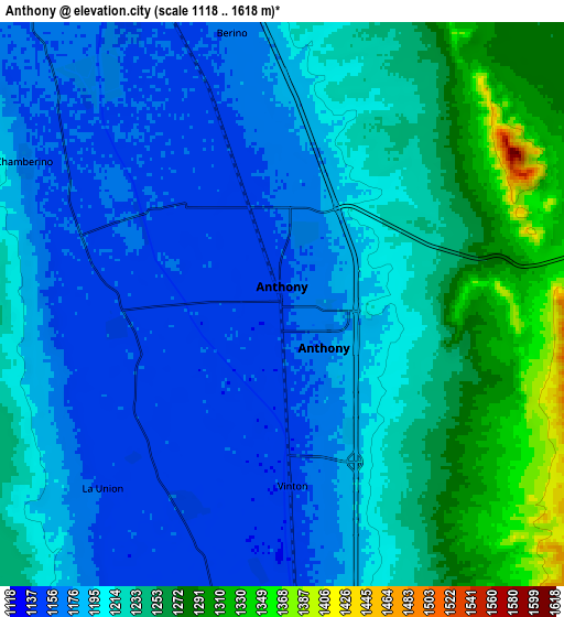
Below is the Elevation map of Anthony, which displays elevation range with different colors. Scale of the first map is from 1127 to 1250 m (3698 to 4101 ft) with average elevation of 1168.7 meters (=3834 ft) [note 1]
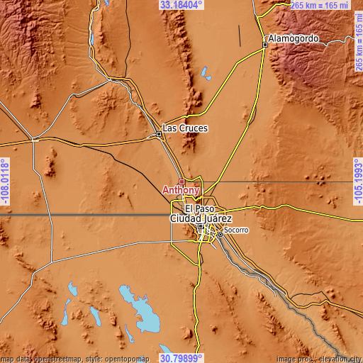
These maps also provides idea of topography and contour of this city, they are displayed at different zoom levels. More info about maps, scale and edge coordinates you can find below images.
| \ | Map #1 | Map #2 | Topo.Map |
| Scale [m] | 1127..1250 m | 1118..1618 m | × |
| Scale [ft] | 3698..4101 ft | 3668..5308 ft | × |
| Average | 1168.7 m = 3834 ft | 1208.6 m = 3965 ft | × |
| Width | 8.29 km = 5.2 mi | 16.58 km = 10.3 mi | 265.2 km = 164.8 mi |
| Height | 8.29 km = 5.2 mi | 16.58 km = 10.3 mi | 265.2 km = 164.8 mi |
| ↑Max Latitude | 32.03653° | 32.073776° | 33.18404° |
| Latitude at center | 31.99927° | 31.99927° | 31.99927° |
| ↓Min Latitude | 31.961994° | 31.924704° | 30.79899° |
| ← Min Longitude | -106.649495° | -106.693441° | -108.0118° |
| Longitude center | -106.60555° | -106.60555° | -106.60555° |
| →Max Longitude | -106.561605° | -106.517659° | -105.1993° |
Nearby cities:
Cities around Anthony sort by population:
• Sunland Park elevation 1156 m
22.7 km,  173°
173°
• Chaparral 1236 m
20.9 km,  82°
82°
• Anthony 1156 m
0.5 km,  357°
357°
• Canutillo 1144 m
9.8 km,  177°
177°
• Santa Teresa 1152 m
16.2 km,  191°
191°
• Westway 1200 m
5.2 km,  150°
150°
• Vado 1161 m
13.6 km,  336°
336°
• Vinton 1152 m
5.4 km, 176°
• Berino 1162 m
8.1 km,  349°
349°
• San Miguel 1168 m
21.2 km,  324°
324°
• Mesquite 1169 m
20.3 km,  334°
334°
• La Union 1153 m
7.6 km,  224°
224°
Multilingual:
 En español:
Anthony elevación 1152 m.
 En France:
Anthony élévation 1152 m.
 Auf Deutsch:
Anthony höhe über dem Meeresspiegel ist 1152 m.

Sources and notes:
- [note 1] Map square and city borders are not equal. Map elevation data is calculated only from area inside that square.
- [src 1] Elevation data from geonames database provided with same terms of usage.
- [src 2] The elevation map of Anthony is generated using elevation data from NASA's 3 arcsec (90m) resolution SRTM data.
- [src 3] Base (background) map © OpenStreetMap contributors tiles are generated by Geofabrik and OpenTopoMap.
Copyright & License:
This Anthony Elevation Map is licensed under CC BY-SA. You may reuse any part from this page, if you give a proper credit by linking to this URL:
 More info on terms of use page.