Cañon City elevation
Cañon City (Colorado, Fremont County), United States elevation is 1635 meters and Cañon City elevation in feet is 5364 ft above sea level [src 1]. Cañon City is a populated place (feature code) with elevation that is 1356 meters (4449 ft) bigger than average city elevation in United States.
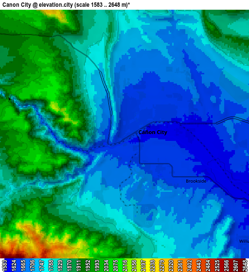
Below is the Elevation map of Cañon City, which displays elevation range with different colors. Scale of the first map is from 1604 to 2172 m (5262 to 7126 ft) with average elevation of 1711.6 meters (=5615 ft) [note 1]
These maps also provides idea of topography and contour of this city, they are displayed at different zoom levels. More info about maps, scale and edge coordinates you can find below images.

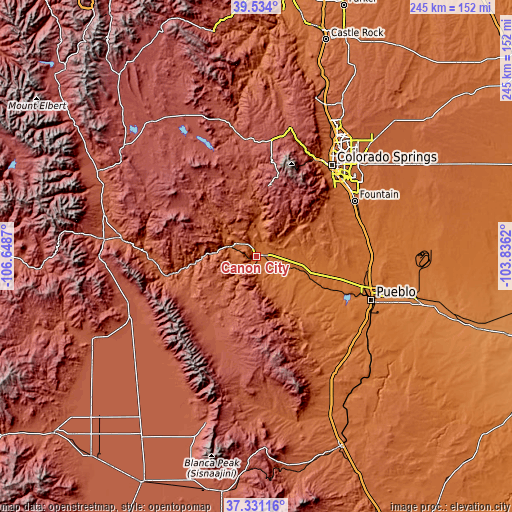
| \ | Map #1 | Map #2 | Topo.Map |
| Scale [m] | 1604..2172 m | 1583..2648 m | × |
| Scale [ft] | 5262..7126 ft | 5194..8688 ft | × |
| Average | 1711.6 m = 5615 ft | 1799 m = 5902 ft | × |
| Width | 7.65 km = 4.8 mi | 15.31 km = 9.5 mi | 244.9 km = 152.2 mi |
| Height | 7.65 km = 4.8 mi | 15.31 km = 9.5 mi | 244.9 km = 152.2 mi |
| ↑Max Latitude | 38.475392° | 38.509787° | 39.534° |
| Latitude at center | 38.44098° | 38.44098° | 38.44098° |
| ↓Min Latitude | 38.406552° | 38.372107° | 37.33116° |
| ← Min Longitude | -105.286395° | -105.330341° | -106.6487° |
| Longitude center | -105.24245° | -105.24245° | -105.24245° |
| →Max Longitude | -105.198505° | -105.154559° | -103.8362° |
Nearby cities:
Cities around Cañon City sort by population:
• Colorado Springs elevation 1838 m
57 km,  39°
39°
• Security-Widefield 1783 m
57.1 km,  53°
53°
• Pueblo West 1548 m
46.4 km,  102°
102°
• Fountain 1694 m
54.2 km,  60°
60°
• Fort Carson 1785 m
51.4 km, 50°
• Stratmoor 1764 m
54.7 km, 47°
• Manitou Springs 1946 m
54.5 km,  31°
31°
• Florence 1583 m
12.2 km,  117°
117°
• Penrose 1629 m
19.2 km, 95°
• Lincoln Park 1644 m
2.4 km, 123°
• Cripple Creek 2887 m
34.4 km,  9°
9°
• Westcliffe 2404 m
39.2 km,  209°
209°
Multilingual:
 En español:
Cañon City elevación 1635 m.
 En France:
Cañon City élévation 1635 m.
 Auf Deutsch:
Cañon City höhe über dem Meeresspiegel ist 1635 m.

Sources and notes:
- [note 1] Map square and city borders are not equal. Map elevation data is calculated only from area inside that square.
- [src 1] Elevation data from geonames database provided with same terms of usage.
- [src 2] The elevation map of Cañon City is generated using elevation data from NASA's 3 arcsec (90m) resolution SRTM data.
- [src 3] Base (background) map © OpenStreetMap contributors tiles are generated by Geofabrik and OpenTopoMap.
Copyright & License:
This Cañon City Elevation Map is licensed under CC BY-SA. You may reuse any part from this page, if you give a proper credit by linking to this URL:
 More info on terms of use page.