Cripple Creek elevation
Cripple Creek (Colorado, Teller County), United States elevation is 2887 meters and Cripple Creek elevation in feet is 9472 ft above sea level [src 1]. Cripple Creek is a seat of a second-order administrative division (feature code) with elevation that is 2608 meters (8556 ft) bigger than average city elevation in United States.
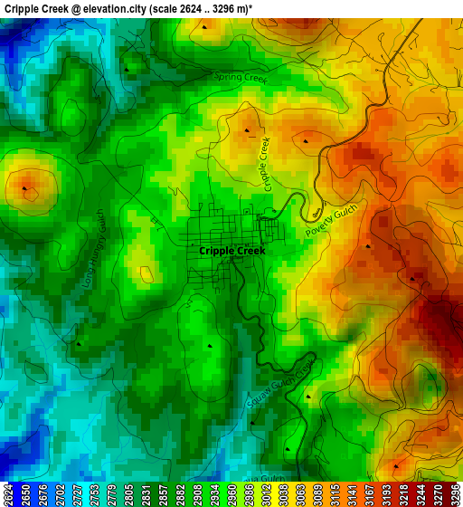
Below is the Elevation map of Cripple Creek, which displays elevation range with different colors. Scale of the first map is from 2624 to 3296 m (8609 to 10814 ft) with average elevation of 2944.1 meters (=9659 ft) [note 1]
These maps also provides idea of topography and contour of this city, they are displayed at different zoom levels. More info about maps, scale and edge coordinates you can find below images.
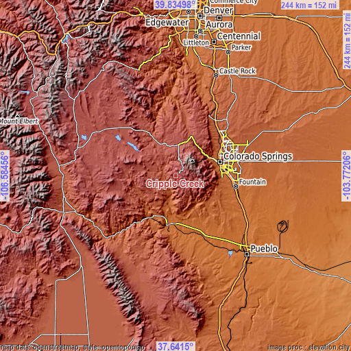
| \ | Map #1 | Topo.Map |
| Scale [m] | 2624..3296 m | × |
| Scale [ft] | 8609..10814 ft | × |
| Average | 2944.1 m = 9659 ft | × |
| Width | 7.62 km = 4.7 mi | 243.9 km = 151.6 mi |
| Height | 7.62 km = 4.7 mi | 243.9 km = 151.6 mi |
| ↑Max Latitude | 38.780926° | 39.83498° |
| Latitude at center | 38.74666° | 38.74666° |
| ↓Min Latitude | 38.712378° | 37.6415° |
| ← Min Longitude | -105.222255° | -106.58456° |
| Longitude center | -105.17831° | -105.17831° |
| →Max Longitude | -105.134365° | -103.77206° |
Nearby cities:
Cities around Cripple Creek sort by population:
• Colorado Springs elevation 1838 m
32.4 km,  72°
72°
• Security-Widefield 1783 m
40.2 km,  89°
89°
• Cañon City 1635 m
34.4 km,  189°
189°
• Fort Carson 1785 m
33.8 km, 91°
• Woodland Park 2590 m
29.4 km,  20°
20°
• Stratmoor 1764 m
34.7 km,  84°
84°
• Air Force Academy 2070 m
38.7 km,  44°
44°
• Manitou Springs 1946 m
25.9 km,  60°
60°
• Florence 1583 m
40 km,  172°
172°
• Penrose 1629 m
38.2 km,  159°
159°
• Lincoln Park 1644 m
35.5 km, 185°
• Cascade-Chipita Park 2570 m
26.7 km,  34°
34°
Multilingual:
 En español:
Cripple Creek elevación 2887 m.
 En France:
Cripple Creek élévation 2887 m.
 Auf Deutsch:
Cripple Creek höhe über dem Meeresspiegel ist 2887 m.

Sources and notes:
- [note 1] Map square and city borders are not equal. Map elevation data is calculated only from area inside that square.
- [src 1] Elevation data from geonames database provided with same terms of usage.
- [src 2] The elevation map of Cripple Creek is generated using elevation data from NASA's 3 arcsec (90m) resolution SRTM data.
- [src 3] Base (background) map © OpenStreetMap contributors tiles are generated by Geofabrik and OpenTopoMap.
Copyright & License:
This Cripple Creek Elevation Map is licensed under CC BY-SA. You may reuse any part from this page, if you give a proper credit by linking to this URL:
 More info on terms of use page.