Mojave elevation
Mojave (California, Kern County), United States elevation is 843 meters and Mojave elevation in feet is 2766 ft above sea level [src 1]. Mojave is a populated place (feature code) with elevation that is 564 meters (1850 ft) bigger than average city elevation in United States.
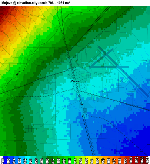
Below is the Elevation map of Mojave, which displays elevation range with different colors. Scale of the first map is from 796 to 1031 m (2612 to 3383 ft) with average elevation of 861 meters (=2825 ft) [note 1]
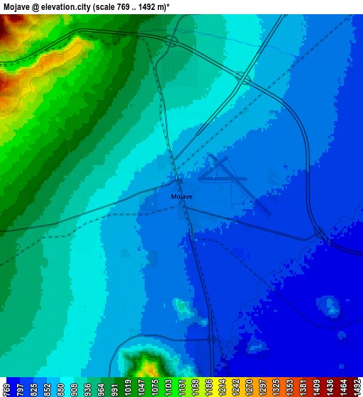
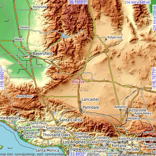
These maps also provides idea of topography and contour of this city, they are displayed at different zoom levels. More info about maps, scale and edge coordinates you can find below images.
| \ | Map #1 | Map #2 | Topo.Map |
| Scale [m] | 796..1031 m | 769..1492 m | × |
| Scale [ft] | 2612..3383 ft | 2523..4895 ft | × |
| Average | 861 m = 2825 ft | 898 m = 2946 ft | × |
| Width | 8 km = 5 mi | 16 km = 9.9 mi | 256 km = 159.1 mi |
| Height | 8 km = 5 mi | 16 km = 9.9 mi | 256 km = 159.1 mi |
| ↑Max Latitude | 35.088437° | 35.124388° | 36.19551° |
| Latitude at center | 35.05247° | 35.05247° | 35.05247° |
| ↓Min Latitude | 35.016487° | 34.980489° | 33.8932° |
| ← Min Longitude | -118.217905° | -118.261851° | -119.58021° |
| Longitude center | -118.17396° | -118.17396° | -118.17396° |
| →Max Longitude | -118.130015° | -118.086069° | -116.76771° |
Nearby cities:
Cities around Mojave sort by population:
• Lancaster elevation 718 m
39.6 km,  175°
175°
• Rosamond 715 m
21 km, 177°
• California City 737 m
19 km,  64°
64°
• Tehachapi 1212 m
26.5 km,  289°
289°
• Quartz Hill 766 m
45.5 km,  185°
185°
• Golden Hills 1198 m
30.5 km, 289°
• Bear Valley Springs 1255 m
43 km, 286°
• Stallion Springs 1157 m
42.8 km,  275°
275°
• Boron 756 m
48.1 km,  97°
97°
• Edwards Air Force Base 731 m
26.5 km,  124°
124°
• Leona Valley 963 m
49.4 km, 192°
• North Edwards 702 m
31.3 km, 97°
Multilingual:
 En español:
Mojave elevación 843 m.
 En France:
Mojave élévation 843 m.


Sources and notes:
- [note 1] Map square and city borders are not equal. Map elevation data is calculated only from area inside that square.
- [src 1] Elevation data from geonames database provided with same terms of usage.
- [src 2] The elevation map of Mojave is generated using elevation data from NASA's 3 arcsec (90m) resolution SRTM data.
- [src 3] Base (background) map © OpenStreetMap contributors tiles are generated by Geofabrik and OpenTopoMap.
Copyright & License:
This Mojave Elevation Map is licensed under CC BY-SA. You may reuse any part from this page, if you give a proper credit by linking to this URL:
 More info on terms of use page.