Boron elevation
Boron (California, Kern County), United States elevation is 756 meters and Boron elevation in feet is 2480 ft above sea level [src 1]. Boron is a populated place (feature code) with elevation that is 477 meters (1565 ft) bigger than average city elevation in United States.
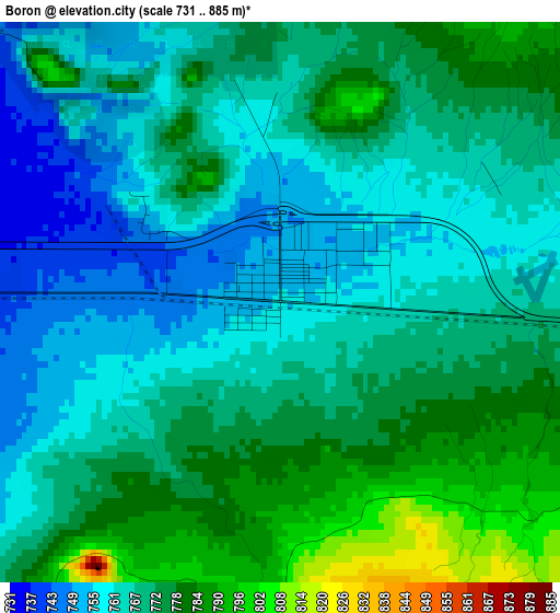
Below is the Elevation map of Boron, which displays elevation range with different colors. Scale of the first map is from 731 to 885 m (2398 to 2904 ft) with average elevation of 769.1 meters (=2523 ft) [note 1]
These maps also provides idea of topography and contour of this city, they are displayed at different zoom levels. More info about maps, scale and edge coordinates you can find below images.
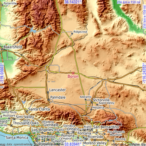
| \ | Map #1 | Topo.Map |
| Scale [m] | 731..885 m | × |
| Scale [ft] | 2398..2904 ft | × |
| Average | 769.1 m = 2523 ft | × |
| Width | 8.01 km = 5 mi | 256.2 km = 159.2 mi |
| Height | 8.01 km = 5 mi | 256.2 km = 159.2 mi |
| ↑Max Latitude | 35.03541° | 36.14321° |
| Latitude at center | 34.99942° | 34.99942° |
| ↓Min Latitude | 34.963414° | 33.83941° |
| ← Min Longitude | -117.693725° | -119.05603° |
| Longitude center | -117.64978° | -117.64978° |
| →Max Longitude | -117.605835° | -116.24353° |
Nearby cities:
Cities around Boron sort by population:
• Lancaster elevation 718 m
55.7 km,  232°
232°
• Adelanto 881 m
51.3 km,  154°
154°
• Barstow Heights 780 m
56 km,  104°
104°
• Rosamond 715 m
49.2 km,  252°
252°
• California City 737 m
33.7 km,  294°
294°
• Lake Los Angeles 812 m
46 km,  200°
200°
• Sun Village 834 m
56.4 km,  209°
209°
• Silver Lakes 754 m
39.9 km,  135°
135°
• Mojave 843 m
48.1 km,  277°
277°
• Lenwood 698 m
51.6 km,  105°
105°
• Edwards Air Force Base 731 m
27.6 km, 250°
• North Edwards 702 m
16.8 km, 276°
Multilingual:
 En español:
Boron elevación 756 m.
 En France:
Boron élévation 756 m.


Sources and notes:
- [note 1] Map square and city borders are not equal. Map elevation data is calculated only from area inside that square.
- [src 1] Elevation data from geonames database provided with same terms of usage.
- [src 2] The elevation map of Boron is generated using elevation data from NASA's 3 arcsec (90m) resolution SRTM data.
- [src 3] Base (background) map © OpenStreetMap contributors tiles are generated by Geofabrik and OpenTopoMap.
Copyright & License:
This Boron Elevation Map is licensed under CC BY-SA. You may reuse any part from this page, if you give a proper credit by linking to this URL:
 More info on terms of use page.