Tehachapi elevation
Tehachapi (California, Kern County), United States elevation is 1212 meters and Tehachapi elevation in feet is 3976 ft above sea level [src 1]. Tehachapi is a populated place (feature code) with elevation that is 933 meters (3061 ft) bigger than average city elevation in United States.
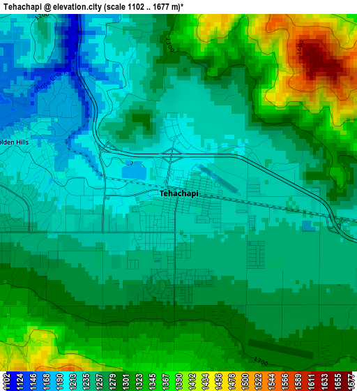
Below is the Elevation map of Tehachapi, which displays elevation range with different colors. Scale of the first map is from 1102 to 1677 m (3615 to 5502 ft) with average elevation of 1273.1 meters (=4177 ft) [note 1]
These maps also provides idea of topography and contour of this city, they are displayed at different zoom levels. More info about maps, scale and edge coordinates you can find below images.
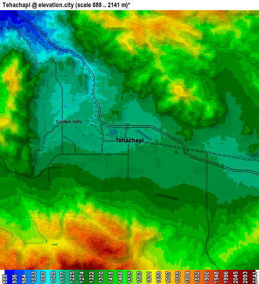
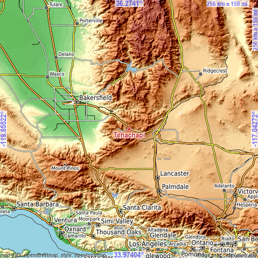
| \ | Map #1 | Map #2 | Topo.Map |
| Scale [m] | 1102..1677 m | 888..2141 m | × |
| Scale [ft] | 3615..5502 ft | 2913..7024 ft | × |
| Average | 1273.1 m = 4177 ft | 1386 m = 4547 ft | × |
| Width | 7.99 km = 5 mi | 15.98 km = 9.9 mi | 255.7 km = 158.9 mi |
| Height | 7.99 km = 5 mi | 15.98 km = 9.9 mi | 255.7 km = 158.9 mi |
| ↑Max Latitude | 35.168122° | 35.204038° | 36.2741° |
| Latitude at center | 35.13219° | 35.13219° | 35.13219° |
| ↓Min Latitude | 35.096242° | 35.060279° | 33.97404° |
| ← Min Longitude | -118.492915° | -118.536861° | -119.85522° |
| Longitude center | -118.44897° | -118.44897° | -118.44897° |
| →Max Longitude | -118.405025° | -118.361079° | -117.04272° |
Nearby cities:
Cities around Tehachapi sort by population:
• Arvin elevation 137 m
35.5 km,  283°
283°
• Rosamond 715 m
39.6 km,  138°
138°
• Lamont 123 m
44.6 km,  288°
288°
• California City 737 m
42.1 km,  90°
90°
• Golden Hills 1198 m
3.9 km, 286°
• Bear Valley Springs 1255 m
16.6 km, 280°
• Mojave 843 m
26.5 km,  109°
109°
• Weedpatch 117 m
44 km, 285°
• Stallion Springs 1157 m
18.3 km,  254°
254°
• Edwards Air Force Base 731 m
52.6 km,  117°
117°
• Bodfish 818 m
50.8 km,  355°
355°
• Lebec 1065 m
49.8 km,  229°
229°
Multilingual:
 En español:
Tehachapi elevación 1212 m.
 En France:
Tehachapi élévation 1212 m.
 Auf Deutsch:
Tehachapi höhe über dem Meeresspiegel ist 1212 m.

Sources and notes:
- [note 1] Map square and city borders are not equal. Map elevation data is calculated only from area inside that square.
- [src 1] Elevation data from geonames database provided with same terms of usage.
- [src 2] The elevation map of Tehachapi is generated using elevation data from NASA's 3 arcsec (90m) resolution SRTM data.
- [src 3] Base (background) map © OpenStreetMap contributors tiles are generated by Geofabrik and OpenTopoMap.
Copyright & License:
This Tehachapi Elevation Map is licensed under CC BY-SA. You may reuse any part from this page, if you give a proper credit by linking to this URL:
 More info on terms of use page.