Inyokern elevation
Inyokern (California, Kern County), United States elevation is 747 meters and Inyokern elevation in feet is 2451 ft above sea level [src 1]. Inyokern is a populated place (feature code) with elevation that is 468 meters (1535 ft) bigger than average city elevation in United States.
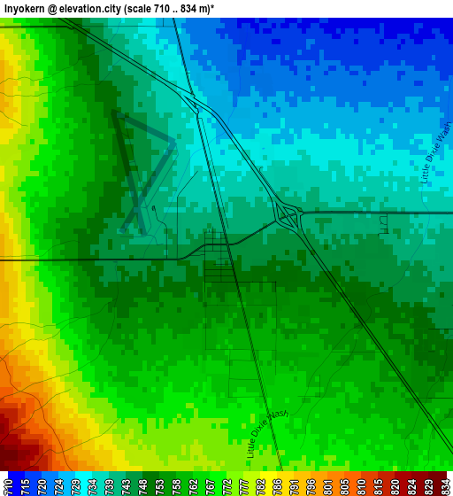
Below is the Elevation map of Inyokern, which displays elevation range with different colors. Scale of the first map is from 710 to 834 m (2329 to 2736 ft) with average elevation of 752.4 meters (=2469 ft) [note 1]
These maps also provides idea of topography and contour of this city, they are displayed at different zoom levels. More info about maps, scale and edge coordinates you can find below images.
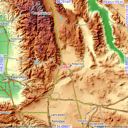
| \ | Map #1 | Topo.Map |
| Scale [m] | 710..834 m | × |
| Scale [ft] | 2329..2736 ft | × |
| Average | 752.4 m = 2469 ft | × |
| Width | 7.94 km = 4.9 mi | 254.1 km = 157.9 mi |
| Height | 7.94 km = 4.9 mi | 254.1 km = 157.9 mi |
| ↑Max Latitude | 35.682603° | 36.78144° |
| Latitude at center | 35.6469° | 35.6469° |
| ↓Min Latitude | 35.611181° | 34.49601° |
| ← Min Longitude | -117.856515° | -119.21882° |
| Longitude center | -117.81257° | -117.81257° |
| →Max Longitude | -117.768625° | -116.40632° |
Nearby cities:
Cities around Inyokern sort by population:
• Ridgecrest elevation 702 m
13.1 km,  101°
101°
• California City 737 m
60 km,  195°
195°
• Alta Sierra 1803 m
67.6 km,  277°
277°
• Lake Isabella 763 m
59.8 km,  266°
266°
• Weldon 812 m
43.2 km, 272°
• Boron 756 m
73.5 km,  168°
168°
• Wofford Heights 817 m
58.5 km, 276°
• Bodfish 818 m
61.8 km,  263°
263°
• China Lake Acres 744 m
4.5 km, 99°
• Searles Valley 630 m
39.3 km,  70°
70°
• Kernville 811 m
56.6 km, 282°
• North Edwards 702 m
70.1 km,  181°
181°
Multilingual:
 En español:
Inyokern elevación 747 m.
 En France:
Inyokern élévation 747 m.
 Auf Deutsch:
Inyokern höhe über dem Meeresspiegel ist 747 m.

Sources and notes:
- [note 1] Map square and city borders are not equal. Map elevation data is calculated only from area inside that square.
- [src 1] Elevation data from geonames database provided with same terms of usage.
- [src 2] The elevation map of Inyokern is generated using elevation data from NASA's 3 arcsec (90m) resolution SRTM data.
- [src 3] Base (background) map © OpenStreetMap contributors tiles are generated by Geofabrik and OpenTopoMap.
Copyright & License:
This Inyokern Elevation Map is licensed under CC BY-SA. You may reuse any part from this page, if you give a proper credit by linking to this URL:
 More info on terms of use page.