Alta Sierra elevation
Alta Sierra (California, Kern County), United States elevation is 1803 meters and Alta Sierra elevation in feet is 5915 ft above sea level [src 1]. Alta Sierra is a populated place (feature code) with elevation that is 1524 meters (5000 ft) bigger than average city elevation in United States.
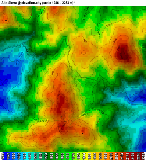
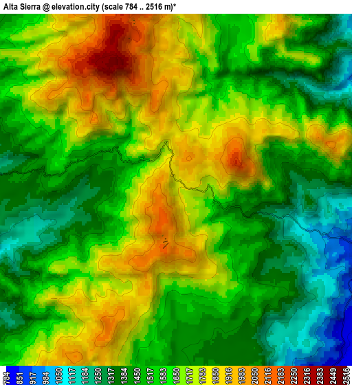
Below is the Elevation map of Alta Sierra, which displays elevation range with different colors. Scale of the first map is from 1286 to 2253 m (4219 to 7392 ft) with average elevation of 1754.7 meters (=5757 ft) [note 1]
These maps also provides idea of topography and contour of this city, they are displayed at different zoom levels. More info about maps, scale and edge coordinates you can find below images.
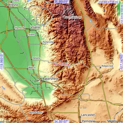
| \ | Map #1 | Map #2 | Topo.Map |
| Scale [m] | 1286..2253 m | 784..2516 m | × |
| Scale [ft] | 4219..7392 ft | 2572..8255 ft | × |
| Average | 1754.7 m = 5757 ft | 1597.5 m = 5241 ft | × |
| Width | 7.93 km = 4.9 mi | 15.87 km = 9.9 mi | 253.8 km = 157.7 mi |
| Height | 7.93 km = 4.9 mi | 15.87 km = 9.9 mi | 253.8 km = 157.7 mi |
| ↑Max Latitude | 35.766925° | 35.802575° | 36.86459° |
| Latitude at center | 35.73126° | 35.73126° | 35.73126° |
| ↓Min Latitude | 35.695579° | 35.659882° | 34.58157° |
| ← Min Longitude | -118.597845° | -118.641791° | -119.96015° |
| Longitude center | -118.5539° | -118.5539° | -118.5539° |
| →Max Longitude | -118.509955° | -118.466009° | -117.14765° |
Nearby cities:
Cities around Alta Sierra sort by population:
• Bakersfield elevation 130 m
57.9 km,  226°
226°
• Porterville 144 m
55.8 km,  311°
311°
• Oildale 147 m
54.5 km, 230°
• McFarland 110 m
61.3 km,  264°
264°
• East Porterville 151 m
52.5 km, 313°
• Lake Isabella 763 m
14.6 km,  149°
149°
• Terra Bella 150 m
51.1 km,  300°
300°
• Richgrove 160 m
50.5 km,  278°
278°
• Weldon 812 m
24.9 km,  107°
107°
• Wofford Heights 817 m
9.2 km, 107°
• Bodfish 818 m
16.9 km,  160°
160°
• Kernville 811 m
11.9 km,  77°
77°
Multilingual:
 En español:
Alta Sierra elevación 1803 m.
 En France:
Alta Sierra élévation 1803 m.
 Auf Deutsch:
Alta Sierra höhe über dem Meeresspiegel ist 1803 m.

Sources and notes:
- [note 1] Map square and city borders are not equal. Map elevation data is calculated only from area inside that square.
- [src 1] Elevation data from geonames database provided with same terms of usage.
- [src 2] The elevation map of Alta Sierra is generated using elevation data from NASA's 3 arcsec (90m) resolution SRTM data.
- [src 3] Base (background) map © OpenStreetMap contributors tiles are generated by Geofabrik and OpenTopoMap.
Copyright & License:
This Alta Sierra Elevation Map is licensed under CC BY-SA. You may reuse any part from this page, if you give a proper credit by linking to this URL:
 More info on terms of use page.