Safford elevation
Safford (Arizona, Graham County), United States elevation is 892 meters and Safford elevation in feet is 2927 ft above sea level [src 1]. Safford is a seat of a second-order administrative division (feature code) with elevation that is 613 meters (2011 ft) bigger than average city elevation in United States.
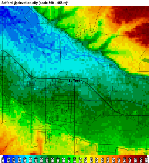
Below is the Elevation map of Safford, which displays elevation range with different colors. Scale of the first map is from 869 to 958 m (2851 to 3143 ft) with average elevation of 903.9 meters (=2966 ft) [note 1]
These maps also provides idea of topography and contour of this city, they are displayed at different zoom levels. More info about maps, scale and edge coordinates you can find below images.
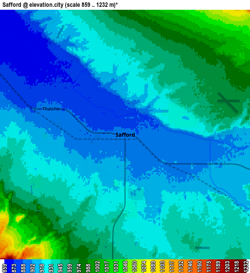
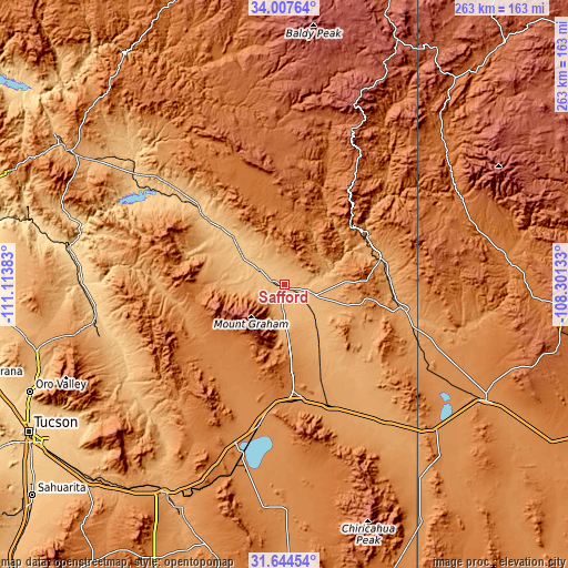
| \ | Map #1 | Map #2 | Topo.Map |
| Scale [m] | 869..958 m | 859..1232 m | × |
| Scale [ft] | 2851..3143 ft | 2818..4042 ft | × |
| Average | 903.9 m = 2966 ft | 932.3 m = 3059 ft | × |
| Width | 8.21 km = 5.1 mi | 16.42 km = 10.2 mi | 262.8 km = 163.3 mi |
| Height | 8.21 km = 5.1 mi | 16.42 km = 10.2 mi | 262.8 km = 163.3 mi |
| ↑Max Latitude | 32.870867° | 32.907769° | 34.00764° |
| Latitude at center | 32.83395° | 32.83395° | 32.83395° |
| ↓Min Latitude | 32.797017° | 32.76007° | 31.64454° |
| ← Min Longitude | -109.751525° | -109.795471° | -111.11383° |
| Longitude center | -109.70758° | -109.70758° | -109.70758° |
| →Max Longitude | -109.663635° | -109.619689° | -108.30133° |
Nearby cities:
Cities around Safford sort by population:
• Thatcher elevation 891 m
5.1 km,  289°
289°
• San Carlos 807 m
89.9 km,  309°
309°
• Clifton 1062 m
45.3 km,  57°
57°
• Willcox 1274 m
65.7 km,  190°
190°
• San Manuel 1052 m
90.2 km,  253°
253°
• Swift Trail Junction 982 m
11.6 km,  182°
182°
• Pima 866 m
13.3 km,  301°
301°
• Bylas 796 m
50.9 km, 310°
• Cactus Flat 950 m
8.4 km, 185°
• Morenci 1463 m
42 km,  49°
49°
• Mammoth 716 m
88.1 km,  261°
261°
• Peridot 793 m
87.5 km, 307°
Multilingual:
 En español:
Safford elevación 892 m.
 En France:
Safford élévation 892 m.


Sources and notes:
- [note 1] Map square and city borders are not equal. Map elevation data is calculated only from area inside that square.
- [src 1] Elevation data from geonames database provided with same terms of usage.
- [src 2] The elevation map of Safford is generated using elevation data from NASA's 3 arcsec (90m) resolution SRTM data.
- [src 3] Base (background) map © OpenStreetMap contributors tiles are generated by Geofabrik and OpenTopoMap.
Copyright & License:
This Safford Elevation Map is licensed under CC BY-SA. You may reuse any part from this page, if you give a proper credit by linking to this URL:
 More info on terms of use page.