San Manuel elevation
San Manuel (Arizona, Pinal County), United States elevation is 1052 meters and San Manuel elevation in feet is 3451 ft above sea level [src 1]. San Manuel is a populated place (feature code) with elevation that is 773 meters (2536 ft) bigger than average city elevation in United States.
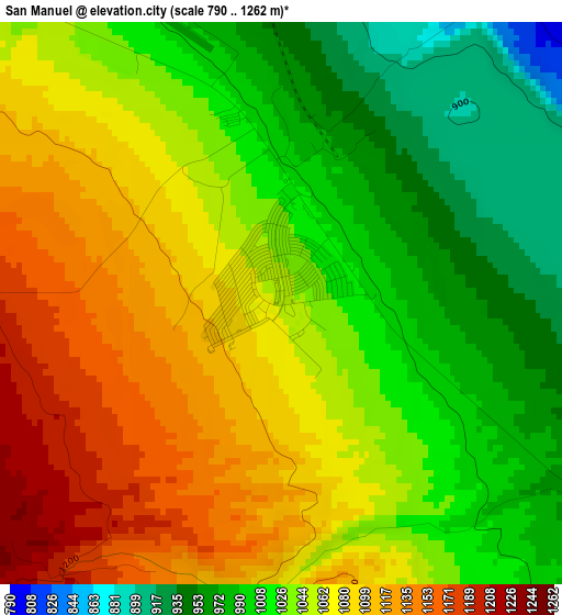
Below is the Elevation map of San Manuel, which displays elevation range with different colors. Scale of the first map is from 790 to 1262 m (2592 to 4140 ft) with average elevation of 1047.8 meters (=3438 ft) [note 1]
These maps also provides idea of topography and contour of this city, they are displayed at different zoom levels. More info about maps, scale and edge coordinates you can find below images.
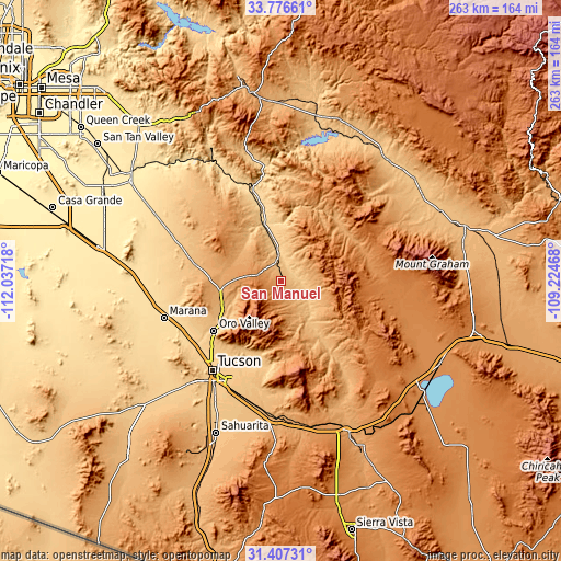
| \ | Map #1 | Map #2 | Topo.Map |
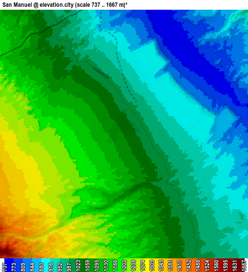
| Scale [m] | 790..1262 m | 737..1667 m | × |
| Scale [ft] | 2592..4140 ft | 2418..5469 ft | × |
| Average | 1047.8 m = 3438 ft | 1040.7 m = 3414 ft | × |
| Width | 8.23 km = 5.1 mi | 16.47 km = 10.2 mi | 263.4 km = 163.7 mi |
| Height | 8.23 km = 5.1 mi | 16.47 km = 10.2 mi | 263.4 km = 163.7 mi |
| ↑Max Latitude | 32.636804° | 32.673803° | 33.77661° |
| Latitude at center | 32.59979° | 32.59979° | 32.59979° |
| ↓Min Latitude | 32.56276° | 32.525716° | 31.40731° |
| ← Min Longitude | -110.674875° | -110.718821° | -112.03718° |
| Longitude center | -110.63093° | -110.63093° | -110.63093° |
| →Max Longitude | -110.586985° | -110.543039° | -109.22468° |
Nearby cities:
Cities around San Manuel sort by population:
• Tucson elevation 757 m
50.4 km,  213°
213°
• Casas Adobes 733 m
46 km,  228°
228°
• Catalina Foothills 777 m
43.1 km,  218°
218°
• Oro Valley 774 m
39.1 km, 233°
• Tanque Verde 809 m
40 km,  194°
194°
• Flowing Wells 692 m
49.2 km, 226°
• Saddle Brooke 1023 m
23.9 km,  252°
252°
• Catalina 960 m
29.1 km, 248°
• South Tucson 737 m
54.6 km, 215°
• Tortolita 819 m
41.9 km,  239°
239°
• Oracle 1379 m
13.2 km,  275°
275°
• Mammoth 716 m
13.7 km,  356°
356°
Multilingual:
 En español:
San Manuel elevación 1052 m.
 En France:
San Manuel élévation 1052 m.
 Auf Deutsch:
San Manuel höhe über dem Meeresspiegel ist 1052 m.

Sources and notes:
- [note 1] Map square and city borders are not equal. Map elevation data is calculated only from area inside that square.
- [src 1] Elevation data from geonames database provided with same terms of usage.
- [src 2] The elevation map of San Manuel is generated using elevation data from NASA's 3 arcsec (90m) resolution SRTM data.
- [src 3] Base (background) map © OpenStreetMap contributors tiles are generated by Geofabrik and OpenTopoMap.
Copyright & License:
This San Manuel Elevation Map is licensed under CC BY-SA. You may reuse any part from this page, if you give a proper credit by linking to this URL:
 More info on terms of use page.