Clifton elevation
Clifton (Arizona, Greenlee County), United States elevation is 1062 meters and Clifton elevation in feet is 3484 ft above sea level [src 1]. Clifton is a seat of a second-order administrative division (feature code) with elevation that is 783 meters (2569 ft) bigger than average city elevation in United States.
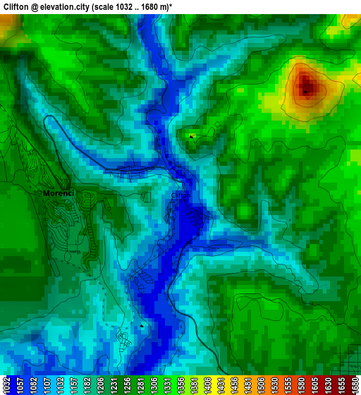
Below is the Elevation map of Clifton, which displays elevation range with different colors. Scale of the first map is from 1032 to 1680 m (3386 to 5512 ft) with average elevation of 1220.8 meters (=4005 ft) [note 1]
These maps also provides idea of topography and contour of this city, they are displayed at different zoom levels. More info about maps, scale and edge coordinates you can find below images.
| \ | Map #1 | Map #2 | Topo.Map |
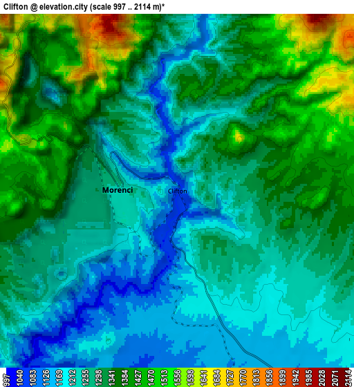
| Scale [m] | 1032..1680 m | 997..2114 m | × |
| Scale [ft] | 3386..5512 ft | 3271..6936 ft | × |
| Average | 1220.8 m = 4005 ft | 1304.2 m = 4279 ft | × |
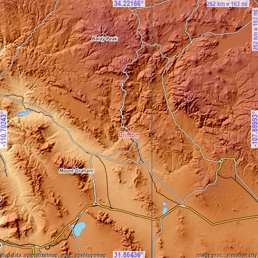
| Width | 8.19 km = 5.1 mi | 16.38 km = 10.2 mi | 262.1 km = 162.9 mi |
| Height | 8.19 km = 5.1 mi | 16.38 km = 10.2 mi | 262.1 km = 162.9 mi |
| ↑Max Latitude | 33.087727° | 33.124538° | 34.22166° |
| Latitude at center | 33.0509° | 33.0509° | 33.0509° |
| ↓Min Latitude | 33.014058° | 32.9772° | 31.86436° |
| ← Min Longitude | -109.340125° | -109.384071° | -110.70243° |
| Longitude center | -109.29618° | -109.29618° | -109.29618° |
| →Max Longitude | -109.252235° | -109.208289° | -107.88993° |
Nearby cities:
Cities around Clifton sort by population:
• Silver City elevation 1808 m
99.8 km,  108°
108°
• Safford 892 m
45.3 km,  237°
237°
• Thatcher 891 m
48.7 km, 242°
• Willcox 1274 m
101.9 km,  209°
209°
• Swift Trail Junction 982 m
52.9 km,  227°
227°
• Lordsburg 1299 m
95.3 km,  144°
144°
• Pima 866 m
52.5 km,  250°
250°
• Bylas 796 m
77.3 km,  276°
276°
• Cactus Flat 950 m
50.9 km, 230°
• Morenci 1463 m
7.1 km,  295°
295°
• Canyon Day 1527 m
106.1 km,  320°
320°
• Reserve 1759 m
89 km,  34°
34°
Multilingual:
 En español:
Clifton elevación 1062 m.
 En France:
Clifton élévation 1062 m.
 Auf Deutsch:
Clifton höhe über dem Meeresspiegel ist 1062 m.

Sources and notes:
- [note 1] Map square and city borders are not equal. Map elevation data is calculated only from area inside that square.
- [src 1] Elevation data from geonames database provided with same terms of usage.
- [src 2] The elevation map of Clifton is generated using elevation data from NASA's 3 arcsec (90m) resolution SRTM data.
- [src 3] Base (background) map © OpenStreetMap contributors tiles are generated by Geofabrik and OpenTopoMap.
Copyright & License:
This Clifton Elevation Map is licensed under CC BY-SA. You may reuse any part from this page, if you give a proper credit by linking to this URL:
 More info on terms of use page.