Nogales elevation
Nogales (Arizona, Santa Cruz County), United States elevation is 1172 meters and Nogales elevation in feet is 3845 ft above sea level [src 1]. Nogales is a seat of a second-order administrative division (feature code) with elevation that is 893 meters (2930 ft) bigger than average city elevation in United States.
Below is the Elevation map of Nogales, which displays elevation range with different colors. Scale of the first map is from 1132 to 1402 m (3714 to 4600 ft) with average elevation of 1223.6 meters (=4014 ft) [note 1]
These maps also provides idea of topography and contour of this city, they are displayed at different zoom levels. More info about maps, scale and edge coordinates you can find below images.
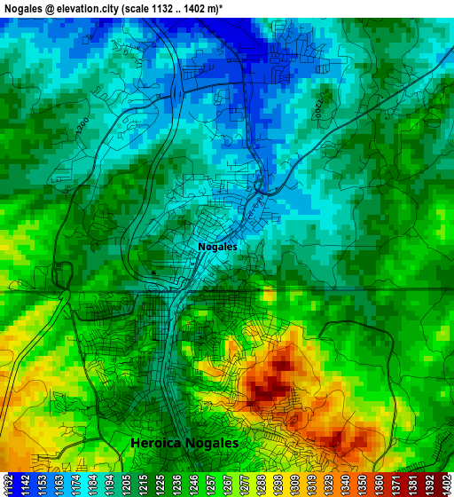
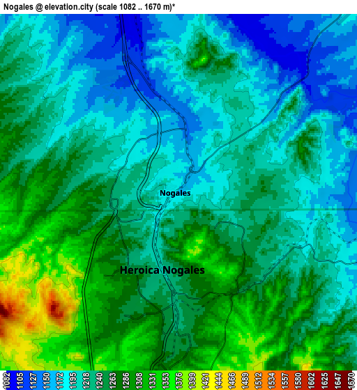
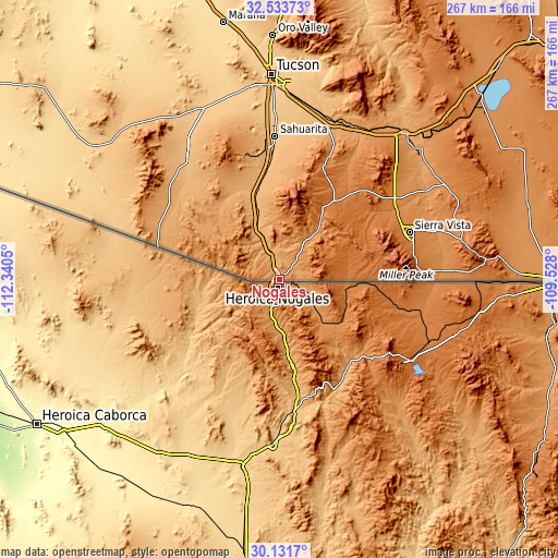
| \ | Map #1 | Map #2 | Topo.Map |
| Scale [m] | 1132..1402 m | 1082..1670 m | × |
| Scale [ft] | 3714..4600 ft | 3550..5479 ft | × |
| Average | 1223.6 m = 4014 ft | 1237.4 m = 4060 ft | × |
| Width | 8.35 km = 5.2 mi | 16.69 km = 10.4 mi | 267.1 km = 166 mi |
| Height | 8.35 km = 5.2 mi | 16.69 km = 10.4 mi | 267.1 km = 166 mi |
| ↑Max Latitude | 31.377906° | 31.415417° | 32.53373° |
| Latitude at center | 31.34038° | 31.34038° | 31.34038° |
| ↓Min Latitude | 31.302839° | 31.265283° | 30.1317° |
| ← Min Longitude | -110.978195° | -111.022141° | -112.3405° |
| Longitude center | -110.93425° | -110.93425° | -110.93425° |
| →Max Longitude | -110.890305° | -110.846359° | -109.528° |
Nearby cities:
Cities around Nogales sort by population:
• Sierra Vista elevation 1416 m
64.4 km,  68°
68°
• Sahuarita 828 m
68.7 km,  358°
358°
• Green Valley 886 m
57.4 km,  354°
354°
• Rio Rico 1063 m
15.1 km,  344°
344°
• Sierra Vista Southeast 1386 m
69.3 km,  79°
79°
• Corona de Tucson 1000 m
71.1 km,  12°
12°
• Summit 799 m
80.8 km, 358°
• Whetstone 1330 m
69.2 km,  54°
54°
• Huachuca City 1347 m
65.3 km,  60°
60°
• East Sahuarita 851 m
67 km,  0°
0°
• Tubac 981 m
32.1 km, 340°
• Arivaca Junction 937 m
44.7 km, 344°
Multilingual:
 En español:
Nogales elevación 1172 m.
 En France:
Nogales élévation 1172 m.
 Auf Deutsch:
Nogales höhe über dem Meeresspiegel ist 1172 m.

Sources and notes:
- [note 1] Map square and city borders are not equal. Map elevation data is calculated only from area inside that square.
- [src 1] Elevation data from geonames database provided with same terms of usage.
- [src 2] The elevation map of Nogales is generated using elevation data from NASA's 3 arcsec (90m) resolution SRTM data.
- [src 3] Base (background) map © OpenStreetMap contributors tiles are generated by Geofabrik and OpenTopoMap.
Copyright & License:
This Nogales Elevation Map is licensed under CC BY-SA. You may reuse any part from this page, if you give a proper credit by linking to this URL:
 More info on terms of use page.