Tubac elevation
Tubac (Arizona, Santa Cruz County), United States elevation is 981 meters and Tubac elevation in feet is 3219 ft above sea level [src 1]. Tubac is a populated place (feature code) with elevation that is 702 meters (2303 ft) bigger than average city elevation in United States.
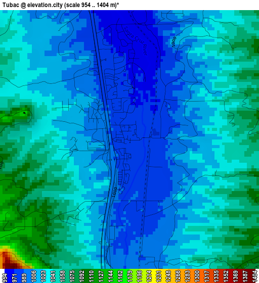
Below is the Elevation map of Tubac, which displays elevation range with different colors. Scale of the first map is from 954 to 1404 m (3130 to 4606 ft) with average elevation of 1026.4 meters (=3367 ft) [note 1]
These maps also provides idea of topography and contour of this city, they are displayed at different zoom levels. More info about maps, scale and edge coordinates you can find below images.
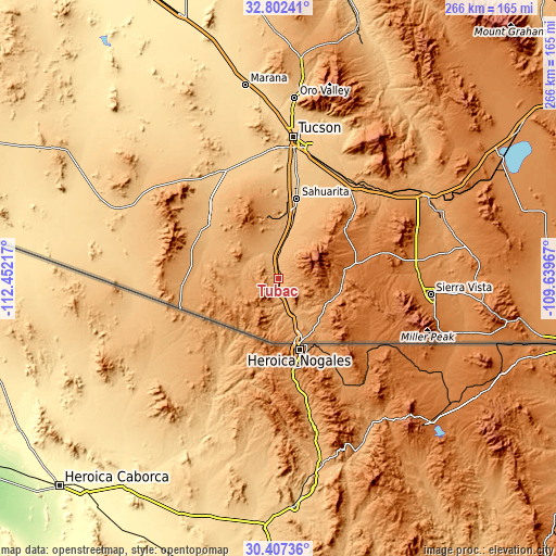
| \ | Map #1 | Topo.Map |
| Scale [m] | 954..1404 m | × |
| Scale [ft] | 3130..4606 ft | × |
| Average | 1026.4 m = 3367 ft | × |
| Width | 8.32 km = 5.2 mi | 266.3 km = 165.5 mi |
| Height | 8.32 km = 5.2 mi | 266.3 km = 165.5 mi |
| ↑Max Latitude | 31.650007° | 32.80241° |
| Latitude at center | 31.61259° | 31.61259° |
| ↓Min Latitude | 31.575158° | 30.40736° |
| ← Min Longitude | -111.089865° | -112.45217° |
| Longitude center | -111.04592° | -111.04592° |
| →Max Longitude | -111.001975° | -109.63967° |
Nearby cities:
Cities around Tubac sort by population:
• Drexel Heights elevation 770 m
58.8 km,  1°
1°
• Sahuarita 828 m
39.3 km,  12°
12°
• Green Valley 886 m
27.3 km, 10°
• Nogales 1172 m
32.1 km,  160°
160°
• Rio Rico 1063 m
17 km, 157°
• Vail 986 m
57.8 km,  33°
33°
• Valencia West 757 m
58.2 km,  353°
353°
• Corona de Tucson 1000 m
46.8 km, 33°
• Three Points 776 m
57.5 km,  333°
333°
• Summit 799 m
51.3 km, 10°
• East Sahuarita 851 m
38.4 km,  16°
16°
• Arivaca Junction 937 m
12.8 km, 353°
Multilingual:
 En español:
Tubac elevación 981 m.
 En France:
Tubac élévation 981 m.


Sources and notes:
- [note 1] Map square and city borders are not equal. Map elevation data is calculated only from area inside that square.
- [src 1] Elevation data from geonames database provided with same terms of usage.
- [src 2] The elevation map of Tubac is generated using elevation data from NASA's 3 arcsec (90m) resolution SRTM data.
- [src 3] Base (background) map © OpenStreetMap contributors tiles are generated by Geofabrik and OpenTopoMap.
Copyright & License:
This Tubac Elevation Map is licensed under CC BY-SA. You may reuse any part from this page, if you give a proper credit by linking to this URL:
 More info on terms of use page.