Manitowoc elevation
Manitowoc (Wisconsin, Manitowoc County), United States elevation is 189 meters and Manitowoc elevation in feet is 620 ft above sea level [src 1]. Manitowoc is a seat of a second-order administrative division (feature code) with elevation that is 90 meters (295 ft) smaller than average city elevation in United States.
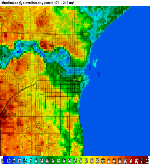
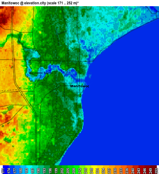
Below is the Elevation map of Manitowoc, which displays elevation range with different colors. Scale of the first map is from 171 to 212 m (561 to 696 ft) with average elevation of 186.6 meters (=612 ft) [note 1]
These maps also provides idea of topography and contour of this city, they are displayed at different zoom levels. More info about maps, scale and edge coordinates you can find below images.
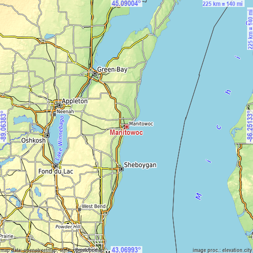
| \ | Map #1 | Map #2 | Topo.Map |
| Scale [m] | 171..212 m | 171..252 m | × |
| Scale [ft] | 561..696 ft | 561..827 ft | × |
| Average | 186.6 m = 612 ft | 191.9 m = 630 ft | × |
| Width | 7.02 km = 4.4 mi | 14.04 km = 8.7 mi | 224.6 km = 139.6 mi |
| Height | 7.02 km = 4.4 mi | 14.04 km = 8.7 mi | 224.6 km = 139.6 mi |
| ↑Max Latitude | 44.120166° | 44.151705° | 45.09004° |
| Latitude at center | 44.08861° | 44.08861° | 44.08861° |
| ↓Min Latitude | 44.057037° | 44.025448° | 43.06993° |
| ← Min Longitude | -87.701525° | -87.745471° | -89.06383° |
| Longitude center | -87.65758° | -87.65758° | -87.65758° |
| →Max Longitude | -87.613635° | -87.569689° | -86.25133° |
Nearby cities:
Cities around Manitowoc sort by population:
• Sheboygan elevation 193 m
37.8 km,  186°
186°
• Two Rivers 184 m
10.1 km,  44°
44°
• Kiel 283 m
36 km,  237°
237°
• Howards Grove 219 m
31.2 km,  204°
204°
• New Holstein 286 m
37.4 km,  245°
245°
• Brillion 256 m
33.9 km,  286°
286°
• Denmark 267 m
31.8 km,  334°
334°
• Cato 261 m
17.3 km, 290°
• Cleveland 196 m
20.6 km, 200°
• Mishicot 184 m
16.8 km,  4°
4°
• Cooperstown 238 m
26.6 km,  339°
339°
• Reedsville 254 m
24.9 km, 286°
Multilingual:
 En español:
Manitowoc elevación 189 m.
 En France:
Manitowoc élévation 189 m.
 Auf Deutsch:
Manitowoc höhe über dem Meeresspiegel ist 189 m.

Sources and notes:
- [note 1] Map square and city borders are not equal. Map elevation data is calculated only from area inside that square.
- [src 1] Elevation data from geonames database provided with same terms of usage.
- [src 2] The elevation map of Manitowoc is generated using elevation data from NASA's 3 arcsec (90m) resolution SRTM data.
- [src 3] Base (background) map © OpenStreetMap contributors tiles are generated by Geofabrik and OpenTopoMap.
Copyright & License:
This Manitowoc Elevation Map is licensed under CC BY-SA. You may reuse any part from this page, if you give a proper credit by linking to this URL:
 More info on terms of use page.