Brillion elevation
Brillion (Wisconsin, Calumet County), United States elevation is 256 meters and Brillion elevation in feet is 840 ft above sea level [src 1]. Brillion is a populated place (feature code) with elevation that is 23 meters (75 ft) smaller than average city elevation in United States.
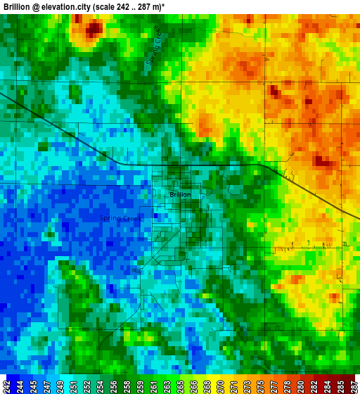
Below is the Elevation map of Brillion, which displays elevation range with different colors. Scale of the first map is from 242 to 287 m (794 to 942 ft) with average elevation of 258.5 meters (=848 ft) [note 1]
These maps also provides idea of topography and contour of this city, they are displayed at different zoom levels. More info about maps, scale and edge coordinates you can find below images.
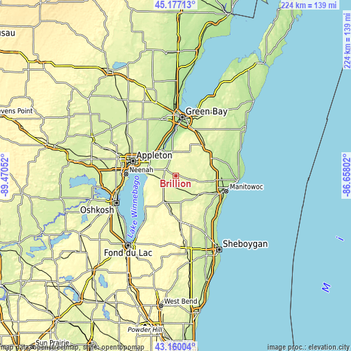
| \ | Map #1 | Topo.Map |
| Scale [m] | 242..287 m | × |
| Scale [ft] | 794..942 ft | × |
| Average | 258.5 m = 848 ft | × |
| Width | 7.01 km = 4.4 mi | 224.3 km = 139.4 mi |
| Height | 7.01 km = 4.4 mi | 224.3 km = 139.4 mi |
| ↑Max Latitude | 44.208719° | 45.17713° |
| Latitude at center | 44.17721° | 44.17721° |
| ↓Min Latitude | 44.145685° | 43.16004° |
| ← Min Longitude | -88.108215° | -89.47052° |
| Longitude center | -88.06427° | -88.06427° |
| →Max Longitude | -88.020325° | -86.65802° |
Nearby cities:
Cities around Brillion sort by population:
• Kaukauna elevation 201 m
20 km,  304°
304°
• Little Chute 225 m
23.3 km, 299°
• Harrison 246 m
22.4 km,  284°
284°
• Kimberly 227 m
24.3 km, 295°
• Chilton 274 m
18.3 km,  205°
205°
• Combined Locks 224 m
22.2 km, 296°
• Wrightstown 191 m
18.3 km,  334°
334°
• New Holstein 286 m
25.3 km,  183°
183°
• Sherwood 274 m
15.6 km,  268°
268°
• Cato 261 m
16.6 km,  103°
103°
• Reedsville 254 m
9 km,  107°
107°
• Hilbert 257 m
9 km,  242°
242°
Multilingual:
 En español:
Brillion elevación 256 m.
 En France:
Brillion élévation 256 m.
 Auf Deutsch:
Brillion höhe über dem Meeresspiegel ist 256 m.

Sources and notes:
- [note 1] Map square and city borders are not equal. Map elevation data is calculated only from area inside that square.
- [src 1] Elevation data from geonames database provided with same terms of usage.
- [src 2] The elevation map of Brillion is generated using elevation data from NASA's 3 arcsec (90m) resolution SRTM data.
- [src 3] Base (background) map © OpenStreetMap contributors tiles are generated by Geofabrik and OpenTopoMap.
Copyright & License:
This Brillion Elevation Map is licensed under CC BY-SA. You may reuse any part from this page, if you give a proper credit by linking to this URL:
 More info on terms of use page.