Ladysmith elevation
Ladysmith (Wisconsin, Rusk County), United States elevation is 348 meters and Ladysmith elevation in feet is 1142 ft above sea level [src 1]. Ladysmith is a seat of a second-order administrative division (feature code) with elevation that is 69 meters (226 ft) bigger than average city elevation in United States.
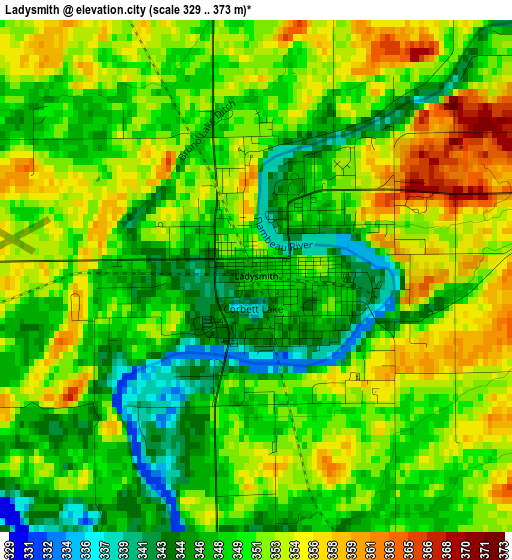
Below is the Elevation map of Ladysmith, which displays elevation range with different colors. Scale of the first map is from 329 to 373 m (1079 to 1224 ft) with average elevation of 350.4 meters (=1150 ft) [note 1]
These maps also provides idea of topography and contour of this city, they are displayed at different zoom levels. More info about maps, scale and edge coordinates you can find below images.
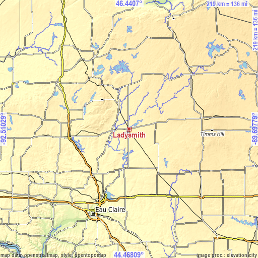
| \ | Map #1 | Topo.Map |
| Scale [m] | 329..373 m | × |
| Scale [ft] | 1079..1224 ft | × |
| Average | 350.4 m = 1150 ft | × |
| Width | 6.85 km = 4.3 mi | 219.3 km = 136.3 mi |
| Height | 6.85 km = 4.3 mi | 219.3 km = 136.3 mi |
| ↑Max Latitude | 45.493833° | 46.4407° |
| Latitude at center | 45.46302° | 45.46302° |
| ↓Min Latitude | 45.43219° | 44.46809° |
| ← Min Longitude | -91.147985° | -92.51029° |
| Longitude center | -91.10404° | -91.10404° |
| →Max Longitude | -91.060095° | -89.69779° |
Nearby cities:
Cities around Ladysmith sort by population:
• Rice Lake elevation 349 m
49.7 km,  275°
275°
• Stanley 330 m
57.4 km,  166°
166°
• Bloomer 300 m
50.3 km,  216°
216°
• Barron 338 m
58.5 km,  263°
263°
• Lake Wissota 279 m
61.6 km,  194°
194°
• Chetek 319 m
45.8 km,  248°
248°
• Cameron 333 m
50.3 km, 263°
• Thorp 371 m
60.7 km,  156°
156°
• Cornell 329 m
33.1 km, 186°
• Cadott 303 m
57.4 km,  183°
183°
• Phillips 436 m
60.6 km,  64°
64°
• Little Round Lake 403 m
59.5 km,  339°
339°
Multilingual:
 En español:
Ladysmith elevación 348 m.
 En France:
Ladysmith élévation 348 m.
 Auf Deutsch:
Ladysmith höhe über dem Meeresspiegel ist 348 m.

Sources and notes:
- [note 1] Map square and city borders are not equal. Map elevation data is calculated only from area inside that square.
- [src 1] Elevation data from geonames database provided with same terms of usage.
- [src 2] The elevation map of Ladysmith is generated using elevation data from NASA's 3 arcsec (90m) resolution SRTM data.
- [src 3] Base (background) map © OpenStreetMap contributors tiles are generated by Geofabrik and OpenTopoMap.
Copyright & License:
This Ladysmith Elevation Map is licensed under CC BY-SA. You may reuse any part from this page, if you give a proper credit by linking to this URL:
 More info on terms of use page.