Stanley elevation
Stanley (Wisconsin, Chippewa County), United States elevation is 330 meters and Stanley elevation in feet is 1083 ft above sea level [src 1]. Stanley is a populated place (feature code) with elevation that is 51 meters (167 ft) bigger than average city elevation in United States.
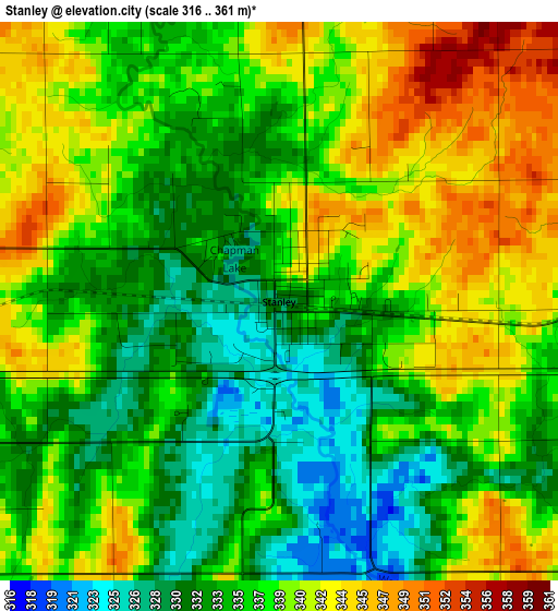
Below is the Elevation map of Stanley, which displays elevation range with different colors. Scale of the first map is from 316 to 361 m (1037 to 1184 ft) with average elevation of 337 meters (=1106 ft) [note 1]
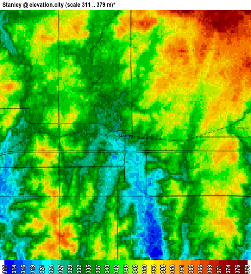
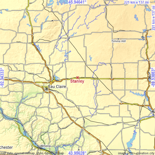
These maps also provides idea of topography and contour of this city, they are displayed at different zoom levels. More info about maps, scale and edge coordinates you can find below images.
| \ | Map #1 | Map #2 | Topo.Map |
| Scale [m] | 316..361 m | 311..379 m | × |
| Scale [ft] | 1037..1184 ft | 1020..1243 ft | × |
| Average | 337 m = 1106 ft | 342.2 m = 1123 ft | × |
| Width | 6.91 km = 4.3 mi | 13.83 km = 8.6 mi | 221.3 km = 137.5 mi |
| Height | 6.91 km = 4.3 mi | 13.83 km = 8.6 mi | 221.3 km = 137.5 mi |
| ↑Max Latitude | 44.991057° | 45.022128° | 45.94641° |
| Latitude at center | 44.95997° | 44.95997° | 44.95997° |
| ↓Min Latitude | 44.928866° | 44.897745° | 43.95628° |
| ← Min Longitude | -90.981025° | -91.024971° | -92.34333° |
| Longitude center | -90.93708° | -90.93708° | -90.93708° |
| →Max Longitude | -90.893135° | -90.849189° | -89.53083° |
Nearby cities:
Cities around Stanley sort by population:
• Chippewa Falls elevation 256 m
36 km,  265°
265°
• Altoona 270 m
43.5 km,  246°
246°
• Lake Hallie 271 m
40.7 km,  256°
256°
• Lake Wissota 279 m
28.9 km, 262°
• Thorp 371 m
10.8 km,  89°
89°
• Augusta 290 m
34.3 km,  204°
204°
• Cornell 329 m
28.4 km,  324°
324°
• Cadott 303 m
16.9 km, 265°
• Seymour 275 m
41.7 km, 249°
• Fall Creek 284 m
34.6 km,  230°
230°
• Loyal 381 m
42.7 km,  125°
125°
• Greenwood 361 m
34 km, 128°
Multilingual:
 En español:
Stanley elevación 330 m.
 En France:
Stanley élévation 330 m.


Sources and notes:
- [note 1] Map square and city borders are not equal. Map elevation data is calculated only from area inside that square.
- [src 1] Elevation data from geonames database provided with same terms of usage.
- [src 2] The elevation map of Stanley is generated using elevation data from NASA's 3 arcsec (90m) resolution SRTM data.
- [src 3] Base (background) map © OpenStreetMap contributors tiles are generated by Geofabrik and OpenTopoMap.
Copyright & License:
This Stanley Elevation Map is licensed under CC BY-SA. You may reuse any part from this page, if you give a proper credit by linking to this URL:
 More info on terms of use page.