Greenwood elevation
Greenwood (Wisconsin, Clark County), United States elevation is 361 meters and Greenwood elevation in feet is 1184 ft above sea level [src 1]. Greenwood is a populated place (feature code) with elevation that is 82 meters (269 ft) bigger than average city elevation in United States.
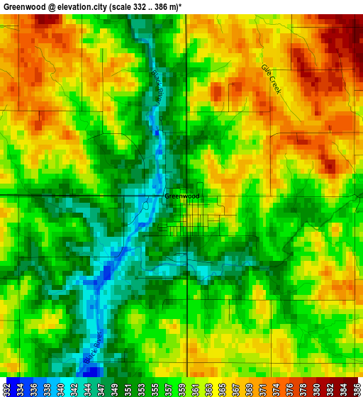
Below is the Elevation map of Greenwood, which displays elevation range with different colors. Scale of the first map is from 332 to 386 m (1089 to 1266 ft) with average elevation of 359.4 meters (=1179 ft) [note 1]
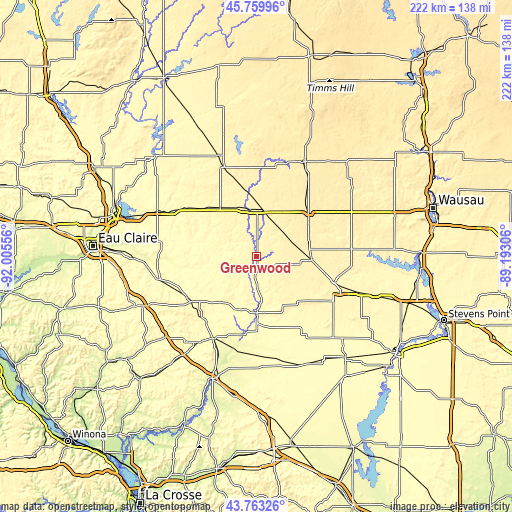
These maps also provides idea of topography and contour of this city, they are displayed at different zoom levels. More info about maps, scale and edge coordinates you can find below images.
| \ | Map #1 | Topo.Map |
| Scale [m] | 332..386 m | × |
| Scale [ft] | 1089..1266 ft | × |
| Average | 359.4 m = 1179 ft | × |
| Width | 6.94 km = 4.3 mi | 222 km = 137.9 mi |
| Height | 6.94 km = 4.3 mi | 222 km = 137.9 mi |
| ↑Max Latitude | 44.80143° | 45.75996° |
| Latitude at center | 44.77024° | 44.77024° |
| ↓Min Latitude | 44.739033° | 43.76326° |
| ← Min Longitude | -90.643255° | -92.00556° |
| Longitude center | -90.59931° | -90.59931° |
| →Max Longitude | -90.555365° | -89.19306° |
Nearby cities:
Cities around Greenwood sort by population:
• Marshfield elevation 394 m
35.6 km,  108°
108°
• Medford 450 m
45.8 km,  26°
26°
• Stanley 330 m
34 km,  308°
308°
• Neillsville 319 m
23.4 km,  179°
179°
• Abbotsford 430 m
29.7 km,  48°
48°
• Spencer 399 m
23.9 km,  93°
93°
• Colby 413 m
27.2 km,  55°
55°
• Thorp 371 m
26.5 km,  323°
323°
• Stratford 387 m
41.2 km, 85°
• Augusta 290 m
42.3 km,  256°
256°
• Cadott 303 m
47.7 km,  294°
294°
• Loyal 381 m
9 km, 114°
Multilingual:
 En español:
Greenwood elevación 361 m.
 En France:
Greenwood élévation 361 m.
 Auf Deutsch:
Greenwood höhe über dem Meeresspiegel ist 361 m.

Sources and notes:
- [note 1] Map square and city borders are not equal. Map elevation data is calculated only from area inside that square.
- [src 1] Elevation data from geonames database provided with same terms of usage.
- [src 2] The elevation map of Greenwood is generated using elevation data from NASA's 3 arcsec (90m) resolution SRTM data.
- [src 3] Base (background) map © OpenStreetMap contributors tiles are generated by Geofabrik and OpenTopoMap.
Copyright & License:
This Greenwood Elevation Map is licensed under CC BY-SA. You may reuse any part from this page, if you give a proper credit by linking to this URL:
 More info on terms of use page.