Marshfield elevation
Marshfield (Wisconsin, Wood County), United States elevation is 394 meters and Marshfield elevation in feet is 1293 ft above sea level [src 1]. Marshfield is a populated place (feature code) with elevation that is 115 meters (377 ft) bigger than average city elevation in United States.
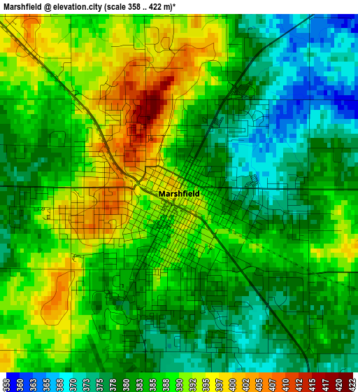
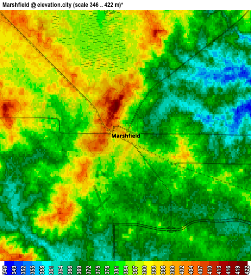
Below is the Elevation map of Marshfield, which displays elevation range with different colors. Scale of the first map is from 358 to 422 m (1175 to 1385 ft) with average elevation of 384.9 meters (=1263 ft) [note 1]
These maps also provides idea of topography and contour of this city, they are displayed at different zoom levels. More info about maps, scale and edge coordinates you can find below images.
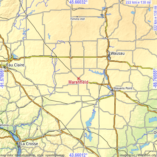
| \ | Map #1 | Map #2 | Topo.Map |
| Scale [m] | 358..422 m | 346..422 m | × |
| Scale [ft] | 1175..1385 ft | 1135..1385 ft | × |
| Average | 384.9 m = 1263 ft | 380.1 m = 1247 ft | × |
| Width | 6.95 km = 4.3 mi | 13.9 km = 8.6 mi | 222.4 km = 138.2 mi |
| Height | 6.95 km = 4.3 mi | 13.9 km = 8.6 mi | 222.4 km = 138.2 mi |
| ↑Max Latitude | 44.700095° | 44.731323° | 45.66032° |
| Latitude at center | 44.66885° | 44.66885° | 44.66885° |
| ↓Min Latitude | 44.637588° | 44.60631° | 43.66012° |
| ← Min Longitude | -90.215745° | -90.259691° | -91.57805° |
| Longitude center | -90.1718° | -90.1718° | -90.1718° |
| →Max Longitude | -90.127855° | -90.083909° | -88.76555° |
Nearby cities:
Cities around Marshfield sort by population:
• Wisconsin Rapids elevation 314 m
42.4 km,  138°
138°
• Mosinee 355 m
39.5 km,  69°
69°
• Neillsville 319 m
35.7 km,  250°
250°
• Abbotsford 430 m
32.9 km,  339°
339°
• Spencer 399 m
14 km,  315°
315°
• Colby 413 m
29.1 km, 337°
• Stratford 387 m
16.4 km,  26°
26°
• Marathon 394 m
39 km,  42°
42°
• Edgar 397 m
33.1 km, 29°
• Loyal 381 m
26.7 km,  286°
286°
• Athens 429 m
41.2 km,  10°
10°
• Greenwood 361 m
35.6 km, 288°
Multilingual:
 En español:
Marshfield elevación 394 m.
 En France:
Marshfield élévation 394 m.
 Auf Deutsch:
Marshfield höhe über dem Meeresspiegel ist 394 m.

Sources and notes:
- [note 1] Map square and city borders are not equal. Map elevation data is calculated only from area inside that square.
- [src 1] Elevation data from geonames database provided with same terms of usage.
- [src 2] The elevation map of Marshfield is generated using elevation data from NASA's 3 arcsec (90m) resolution SRTM data.
- [src 3] Base (background) map © OpenStreetMap contributors tiles are generated by Geofabrik and OpenTopoMap.
Copyright & License:
This Marshfield Elevation Map is licensed under CC BY-SA. You may reuse any part from this page, if you give a proper credit by linking to this URL:
 More info on terms of use page.