Barron elevation
Barron (Wisconsin, Barron County), United States elevation is 338 meters and Barron elevation in feet is 1109 ft above sea level [src 1]. Barron is a seat of a second-order administrative division (feature code) with elevation that is 59 meters (194 ft) bigger than average city elevation in United States.
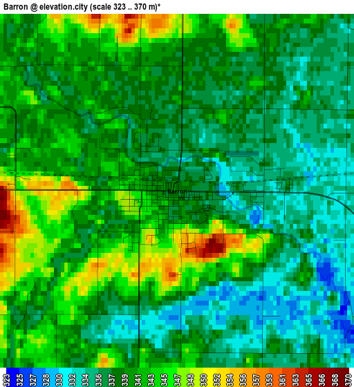
Below is the Elevation map of Barron, which displays elevation range with different colors. Scale of the first map is from 323 to 370 m (1060 to 1214 ft) with average elevation of 339.5 meters (=1114 ft) [note 1]
These maps also provides idea of topography and contour of this city, they are displayed at different zoom levels. More info about maps, scale and edge coordinates you can find below images.
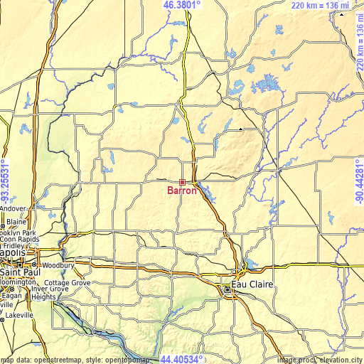
| \ | Map #1 | Topo.Map |
| Scale [m] | 323..370 m | × |
| Scale [ft] | 1060..1214 ft | × |
| Average | 339.5 m = 1114 ft | × |
| Width | 6.86 km = 4.3 mi | 219.6 km = 136.5 mi |
| Height | 6.86 km = 4.3 mi | 219.6 km = 136.5 mi |
| ↑Max Latitude | 45.432197° | 46.3801° |
| Latitude at center | 45.40135° | 45.40135° |
| ↓Min Latitude | 45.370486° | 44.40534° |
| ← Min Longitude | -91.893005° | -93.25531° |
| Longitude center | -91.84906° | -91.84906° |
| →Max Longitude | -91.805115° | -90.44281° |
Nearby cities:
Cities around Barron sort by population:
• Rice Lake elevation 349 m
14.5 km,  36°
36°
• Bloomer 300 m
43.8 km,  139°
139°
• Amery 323 m
41.4 km,  255°
255°
• Tainter Lake 268 m
45.8 km,  179°
179°
• Chetek 319 m
18.3 km,  122°
122°
• Cumberland 377 m
19.7 km,  317°
317°
• Cameron 333 m
8.2 km,  84°
84°
• Shell Lake 378 m
38.1 km,  351°
351°
• Glenwood City 314 m
45.8 km,  213°
213°
• Boyceville 286 m
42.5 km,  200°
200°
• Clear Lake 361 m
37 km,  243°
243°
• Turtle Lake 384 m
22.9 km,  268°
268°
Multilingual:
 En español:
Barron elevación 338 m.
 En France:
Barron élévation 338 m.


Sources and notes:
- [note 1] Map square and city borders are not equal. Map elevation data is calculated only from area inside that square.
- [src 1] Elevation data from geonames database provided with same terms of usage.
- [src 2] The elevation map of Barron is generated using elevation data from NASA's 3 arcsec (90m) resolution SRTM data.
- [src 3] Base (background) map © OpenStreetMap contributors tiles are generated by Geofabrik and OpenTopoMap.
Copyright & License:
This Barron Elevation Map is licensed under CC BY-SA. You may reuse any part from this page, if you give a proper credit by linking to this URL:
 More info on terms of use page.