Clinton elevation
Clinton (Wisconsin, Rock County), United States elevation is 295 meters and Clinton elevation in feet is 968 ft above sea level [src 1]. Clinton is a populated place (feature code) with elevation that is 16 meters (52 ft) bigger than average city elevation in United States.
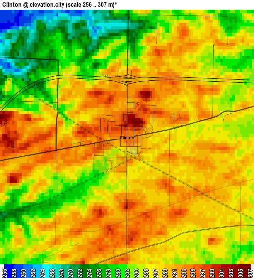
Below is the Elevation map of Clinton, which displays elevation range with different colors. Scale of the first map is from 256 to 307 m (840 to 1007 ft) with average elevation of 286.3 meters (=939 ft) [note 1]
These maps also provides idea of topography and contour of this city, they are displayed at different zoom levels. More info about maps, scale and edge coordinates you can find below images.
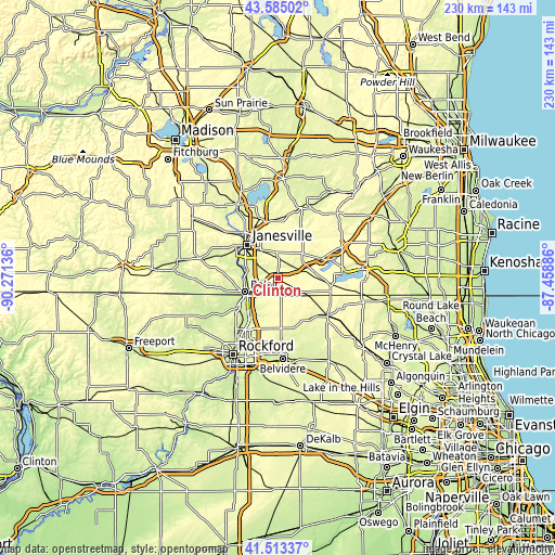
| \ | Map #1 | Topo.Map |
| Scale [m] | 256..307 m | × |
| Scale [ft] | 840..1007 ft | × |
| Average | 286.3 m = 939 ft | × |
| Width | 7.2 km = 4.5 mi | 230.3 km = 143.1 mi |
| Height | 7.2 km = 4.5 mi | 230.3 km = 143.1 mi |
| ↑Max Latitude | 42.590152° | 43.58502° |
| Latitude at center | 42.55779° | 42.55779° |
| ↓Min Latitude | 42.525412° | 41.51337° |
| ← Min Longitude | -88.909055° | -90.27136° |
| Longitude center | -88.86511° | -88.86511° |
| →Max Longitude | -88.821165° | -87.45886° |
Nearby cities:
Cities around Clinton sort by population:
• Janesville elevation 257 m
18.7 km,  317°
317°
• Beloit 231 m
14.7 km,  248°
248°
• Roscoe 228 m
19.9 km,  216°
216°
• Delavan 288 m
20 km,  65°
65°
• South Beloit 225 m
15.8 km,  242°
242°
• Rockton 226 m
20.6 km, 235°
• Poplar Grove 278 m
21.4 km,  170°
170°
• Richmond 303 m
19.9 km,  28°
28°
• Delavan Lake 293 m
19.3 km,  81°
81°
• Darien 293 m
13.8 km, 69°
• Sharon 306 m
12.7 km,  118°
118°
• Capron 281 m
20.3 km,  149°
149°
Multilingual:
 En español:
Clinton elevación 295 m.
 En France:
Clinton élévation 295 m.


Sources and notes:
- [note 1] Map square and city borders are not equal. Map elevation data is calculated only from area inside that square.
- [src 1] Elevation data from geonames database provided with same terms of usage.
- [src 2] The elevation map of Clinton is generated using elevation data from NASA's 3 arcsec (90m) resolution SRTM data.
- [src 3] Base (background) map © OpenStreetMap contributors tiles are generated by Geofabrik and OpenTopoMap.
Copyright & License:
This Clinton Elevation Map is licensed under CC BY-SA. You may reuse any part from this page, if you give a proper credit by linking to this URL:
 More info on terms of use page.