Janesville elevation
Janesville (Wisconsin, Rock County), United States elevation is 257 meters and Janesville elevation in feet is 843 ft above sea level [src 1]. Janesville is a seat of a second-order administrative division (feature code) with elevation that is 22 meters (72 ft) smaller than average city elevation in United States.
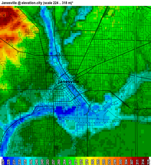
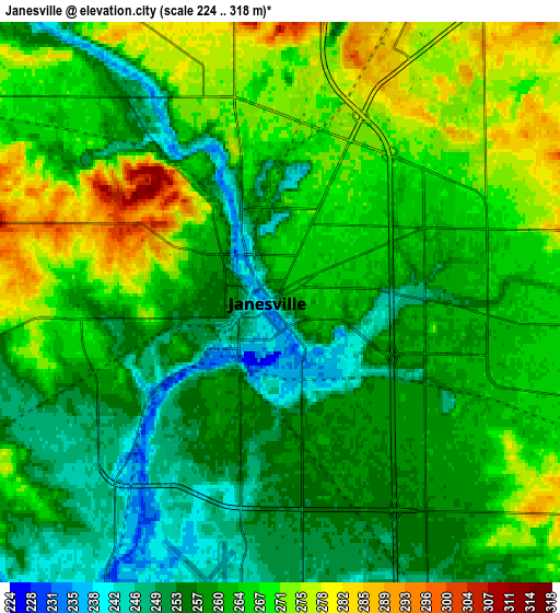
Below is the Elevation map of Janesville, which displays elevation range with different colors. Scale of the first map is from 224 to 318 m (735 to 1043 ft) with average elevation of 257.2 meters (=844 ft) [note 1]
These maps also provides idea of topography and contour of this city, they are displayed at different zoom levels. More info about maps, scale and edge coordinates you can find below images.
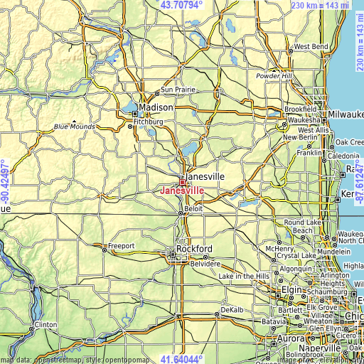
| \ | Map #1 | Map #2 | Topo.Map |
| Scale [m] | 224..318 m | 224..318 m | × |
| Scale [ft] | 735..1043 ft | 735..1043 ft | × |
| Average | 257.2 m = 844 ft | 262.4 m = 861 ft | × |
| Width | 7.18 km = 4.5 mi | 14.37 km = 8.9 mi | 229.9 km = 142.9 mi |
| Height | 7.18 km = 4.5 mi | 14.37 km = 8.9 mi | 229.9 km = 142.9 mi |
| ↑Max Latitude | 42.715087° | 42.747366° | 43.70794° |
| Latitude at center | 42.68279° | 42.68279° | 42.68279° |
| ↓Min Latitude | 42.650477° | 42.618146° | 41.64044° |
| ← Min Longitude | -89.062665° | -89.106611° | -90.42497° |
| Longitude center | -89.01872° | -89.01872° | -89.01872° |
| →Max Longitude | -88.974775° | -88.930829° | -87.61247° |
Nearby cities:
Cities around Janesville sort by population:
• Beloit elevation 231 m
19.4 km,  183°
183°
• Whitewater 252 m
28.8 km,  54°
54°
• South Beloit 225 m
21.1 km, 184°
• Rockton 226 m
26 km,  189°
189°
• Milton 274 m
12 km,  30°
30°
• Edgerton 253 m
17.4 km,  346°
346°
• Evansville 281 m
25.3 km,  295°
295°
• Richmond 303 m
22.3 km,  80°
80°
• Clinton 295 m
18.7 km,  137°
137°
• Darien 293 m
27 km,  109°
109°
• Orfordville 271 m
20.1 km,  252°
252°
• Lake Koshkonong 240 m
26.5 km,  17°
17°
Multilingual:
 En español:
Janesville elevación 257 m.
 En France:
Janesville élévation 257 m.
 Auf Deutsch:
Janesville höhe über dem Meeresspiegel ist 257 m.

Sources and notes:
- [note 1] Map square and city borders are not equal. Map elevation data is calculated only from area inside that square.
- [src 1] Elevation data from geonames database provided with same terms of usage.
- [src 2] The elevation map of Janesville is generated using elevation data from NASA's 3 arcsec (90m) resolution SRTM data.
- [src 3] Base (background) map © OpenStreetMap contributors tiles are generated by Geofabrik and OpenTopoMap.
Copyright & License:
This Janesville Elevation Map is licensed under CC BY-SA. You may reuse any part from this page, if you give a proper credit by linking to this URL:
 More info on terms of use page.