Ashland elevation
Ashland (Wisconsin, Ashland County), United States elevation is 195 meters and Ashland elevation in feet is 640 ft above sea level [src 1]. Ashland is a seat of a second-order administrative division (feature code) with elevation that is 84 meters (276 ft) smaller than average city elevation in United States.
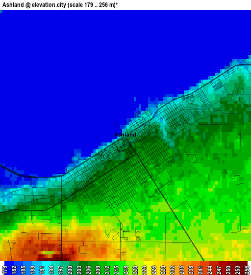
Below is the Elevation map of Ashland, which displays elevation range with different colors. Scale of the first map is from 179 to 256 m (587 to 840 ft) with average elevation of 196.7 meters (=645 ft) [note 1]
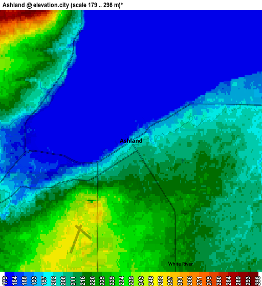
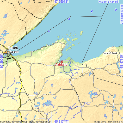
These maps also provides idea of topography and contour of this city, they are displayed at different zoom levels. More info about maps, scale and edge coordinates you can find below images.
| \ | Map #1 | Map #2 | Topo.Map |
| Scale [m] | 179..256 m | 179..298 m | × |
| Scale [ft] | 587..840 ft | 587..978 ft | × |
| Average | 196.7 m = 645 ft | 204.9 m = 672 ft | × |
| Width | 6.72 km = 4.2 mi | 13.43 km = 8.3 mi | 214.9 km = 133.5 mi |
| Height | 6.72 km = 4.2 mi | 13.43 km = 8.3 mi | 214.9 km = 133.5 mi |
| ↑Max Latitude | 46.62263° | 46.652803° | 47.55018° |
| Latitude at center | 46.59244° | 46.59244° | 46.59244° |
| ↓Min Latitude | 46.562233° | 46.532009° | 45.61747° |
| ← Min Longitude | -90.927745° | -90.971691° | -92.29005° |
| Longitude center | -90.8838° | -90.8838° | -90.8838° |
| →Max Longitude | -90.839855° | -90.795909° | -89.47755° |
Nearby cities:
Cities around Ashland sort by population:
• Superior elevation 194 m
94.2 km,  278°
278°
• Ironwood 459 m
56.6 km,  105°
105°
• Two Harbors 207 m
76.7 km,  308°
308°
• Park Falls 464 m
80.7 km,  155°
155°
• Hayward 362 m
79.3 km,  215°
215°
• Washburn 208 m
9 km,  354°
354°
• Silver Bay 232 m
83 km,  340°
340°
• Bessemer 440 m
64.7 km,  101°
101°
• Wakefield 467 m
73.4 km, 100°
• Hurley 456 m
55.7 km, 106°
• Little Round Lake 403 m
79.1 km,  208°
208°
• Lake Nebagamon 351 m
63 km,  262°
262°
Multilingual:
 En español:
Ashland elevación 195 m.
 En France:
Ashland élévation 195 m.


Sources and notes:
- [note 1] Map square and city borders are not equal. Map elevation data is calculated only from area inside that square.
- [src 1] Elevation data from geonames database provided with same terms of usage.
- [src 2] The elevation map of Ashland is generated using elevation data from NASA's 3 arcsec (90m) resolution SRTM data.
- [src 3] Base (background) map © OpenStreetMap contributors tiles are generated by Geofabrik and OpenTopoMap.
Copyright & License:
This Ashland Elevation Map is licensed under CC BY-SA. You may reuse any part from this page, if you give a proper credit by linking to this URL:
 More info on terms of use page.