Superior elevation
Superior (Wisconsin, Douglas County), United States elevation is 194 meters and Superior elevation in feet is 636 ft above sea level [src 1]. Superior is a seat of a second-order administrative division (feature code) with elevation that is 85 meters (279 ft) smaller than average city elevation in United States.
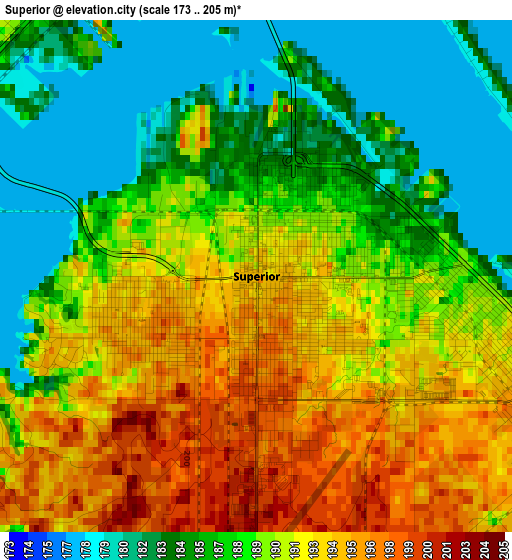
Below is the Elevation map of Superior, which displays elevation range with different colors. Scale of the first map is from 173 to 205 m (568 to 673 ft) with average elevation of 189.2 meters (=621 ft) [note 1]
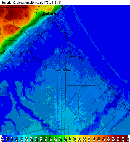
These maps also provides idea of topography and contour of this city, they are displayed at different zoom levels. More info about maps, scale and edge coordinates you can find below images.
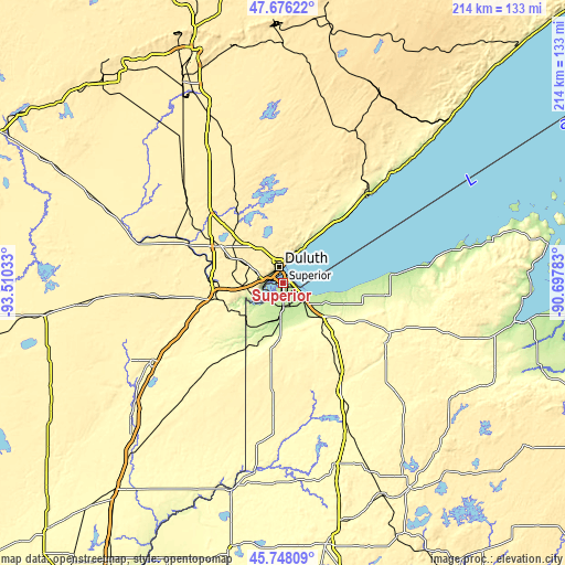
| \ | Map #1 | Map #2 | Topo.Map |
| Scale [m] | 173..205 m | 173..418 m | × |
| Scale [ft] | 568..673 ft | 568..1371 ft | × |
| Average | 189.2 m = 621 ft | 201.7 m = 662 ft | × |
| Width | 6.7 km = 4.2 mi | 13.4 km = 8.3 mi | 214.4 km = 133.2 mi |
| Height | 6.7 km = 4.2 mi | 13.4 km = 8.3 mi | 214.4 km = 133.2 mi |
| ↑Max Latitude | 46.750888° | 46.78099° | 47.67622° |
| Latitude at center | 46.72077° | 46.72077° | 46.72077° |
| ↓Min Latitude | 46.690635° | 46.660483° | 45.74809° |
| ← Min Longitude | -92.148025° | -92.191971° | -93.51033° |
| Longitude center | -92.10408° | -92.10408° | -92.10408° |
| →Max Longitude | -92.060135° | -92.016189° | -90.69783° |
Nearby cities:
Cities around Superior sort by population:
• Duluth elevation 216 m
7 km,  358°
358°
• Cloquet 366 m
27.1 km,  270°
270°
• Hermantown 414 m
14 km,  313°
313°
• Eveleth 486 m
88.8 km,  338°
338°
• Two Harbors 207 m
47 km,  44°
44°
• Proctor 379 m
9.7 km,  287°
287°
• Arnold 439 m
17.8 km,  3°
3°
• Sandstone 332 m
87.9 km,  221°
221°
• Moose Lake 323 m
58.4 km,  239°
239°
• Esko 356 m
19.8 km, 265°
• Lake Nebagamon 351 m
38.4 km,  126°
126°
• Carlton 329 m
25.3 km,  255°
255°
Multilingual:
 En español:
Superior elevación 194 m.
 En France:
Superior élévation 194 m.
 Auf Deutsch:
Superior höhe über dem Meeresspiegel ist 194 m.

Sources and notes:
- [note 1] Map square and city borders are not equal. Map elevation data is calculated only from area inside that square.
- [src 1] Elevation data from geonames database provided with same terms of usage.
- [src 2] The elevation map of Superior is generated using elevation data from NASA's 3 arcsec (90m) resolution SRTM data.
- [src 3] Base (background) map © OpenStreetMap contributors tiles are generated by Geofabrik and OpenTopoMap.
Copyright & License:
This Superior Elevation Map is licensed under CC BY-SA. You may reuse any part from this page, if you give a proper credit by linking to this URL:
 More info on terms of use page.