Cloquet elevation
Cloquet (Minnesota, Carlton County), United States elevation is 366 meters and Cloquet elevation in feet is 1201 ft above sea level [src 1]. Cloquet is a populated place (feature code) with elevation that is 87 meters (285 ft) bigger than average city elevation in United States.
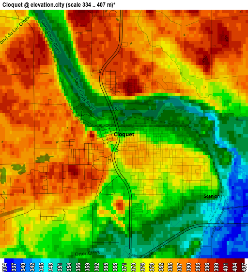
Below is the Elevation map of Cloquet, which displays elevation range with different colors. Scale of the first map is from 334 to 407 m (1096 to 1335 ft) with average elevation of 375.7 meters (=1233 ft) [note 1]
These maps also provides idea of topography and contour of this city, they are displayed at different zoom levels. More info about maps, scale and edge coordinates you can find below images.
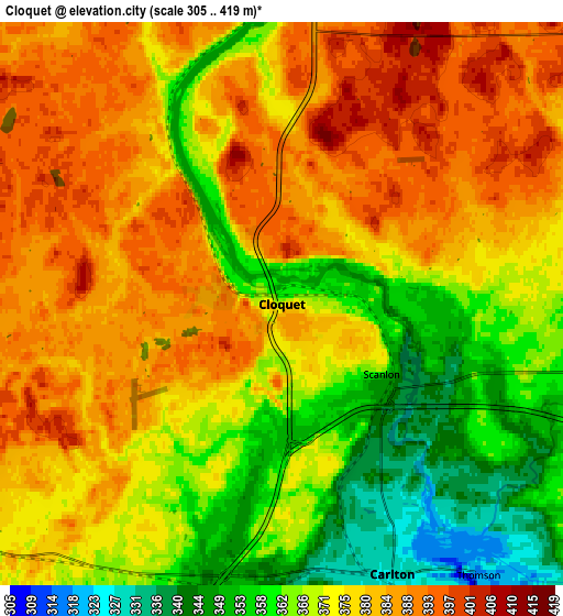
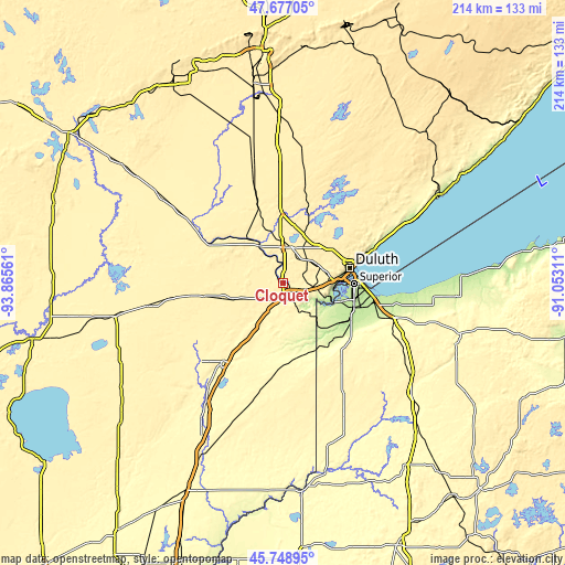
| \ | Map #1 | Map #2 | Topo.Map |
| Scale [m] | 334..407 m | 305..419 m | × |
| Scale [ft] | 1096..1335 ft | 1001..1375 ft | × |
| Average | 375.7 m = 1233 ft | 374.8 m = 1230 ft | × |
| Width | 6.7 km = 4.2 mi | 13.4 km = 8.3 mi | 214.4 km = 133.2 mi |
| Height | 6.7 km = 4.2 mi | 13.4 km = 8.3 mi | 214.4 km = 133.2 mi |
| ↑Max Latitude | 46.751728° | 46.781829° | 47.67705° |
| Latitude at center | 46.72161° | 46.72161° | 46.72161° |
| ↓Min Latitude | 46.691475° | 46.661323° | 45.74895° |
| ← Min Longitude | -92.503305° | -92.547251° | -93.86561° |
| Longitude center | -92.45936° | -92.45936° | -92.45936° |
| →Max Longitude | -92.415415° | -92.371469° | -91.05311° |
Nearby cities:
Cities around Cloquet sort by population:
• Duluth elevation 216 m
27.7 km,  75°
75°
• Superior 194 m
27.1 km,  90°
90°
• Hermantown 414 m
19.3 km,  60°
60°
• Eveleth 486 m
82.6 km,  355°
355°
• Two Harbors 207 m
68.7 km, 60°
• Proctor 379 m
18 km, 80°
• Arnold 439 m
33.2 km, 57°
• Sandstone 332 m
72.7 km,  205°
205°
• Moose Lake 323 m
37.7 km,  217°
217°
• Esko 356 m
7.5 km,  103°
103°
• Lake Nebagamon 351 m
62.4 km,  111°
111°
• Carlton 329 m
6.9 km,  157°
157°
Multilingual:
 En español:
Cloquet elevación 366 m.
 En France:
Cloquet élévation 366 m.


Sources and notes:
- [note 1] Map square and city borders are not equal. Map elevation data is calculated only from area inside that square.
- [src 1] Elevation data from geonames database provided with same terms of usage.
- [src 2] The elevation map of Cloquet is generated using elevation data from NASA's 3 arcsec (90m) resolution SRTM data.
- [src 3] Base (background) map © OpenStreetMap contributors tiles are generated by Geofabrik and OpenTopoMap.
Copyright & License:
This Cloquet Elevation Map is licensed under CC BY-SA. You may reuse any part from this page, if you give a proper credit by linking to this URL:
 More info on terms of use page.