Ironwood elevation
Ironwood (Michigan, Gogebic County), United States elevation is 459 meters and Ironwood elevation in feet is 1506 ft above sea level [src 1]. Ironwood is a populated place (feature code) with elevation that is 180 meters (591 ft) bigger than average city elevation in United States.
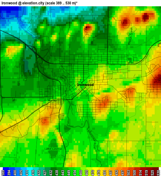
Below is the Elevation map of Ironwood, which displays elevation range with different colors. Scale of the first map is from 389 to 530 m (1276 to 1739 ft) with average elevation of 455.4 meters (=1494 ft) [note 1]
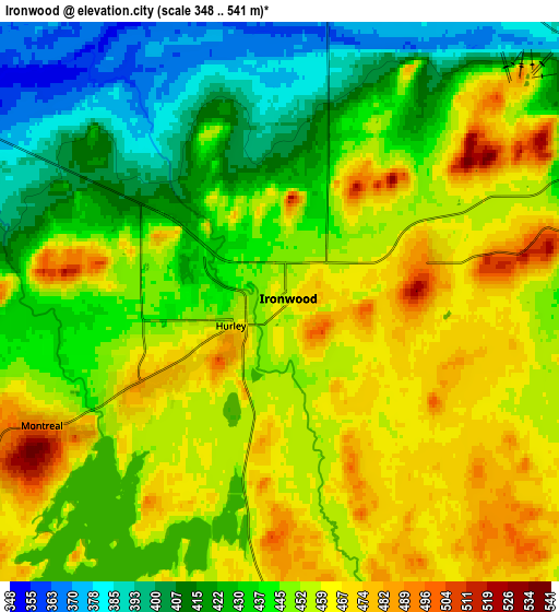
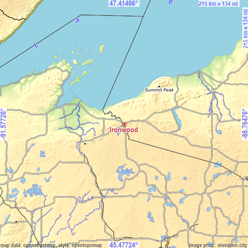
These maps also provides idea of topography and contour of this city, they are displayed at different zoom levels. More info about maps, scale and edge coordinates you can find below images.
| \ | Map #1 | Map #2 | Topo.Map |
| Scale [m] | 389..530 m | 348..541 m | × |
| Scale [ft] | 1276..1739 ft | 1142..1775 ft | × |
| Average | 455.4 m = 1494 ft | 444.9 m = 1460 ft | × |
| Width | 6.73 km = 4.2 mi | 13.47 km = 8.4 mi | 215.4 km = 133.8 mi |
| Height | 6.73 km = 4.2 mi | 13.47 km = 8.4 mi | 215.4 km = 133.8 mi |
| ↑Max Latitude | 46.484937° | 46.515187° | 47.41486° |
| Latitude at center | 46.45467° | 46.45467° | 46.45467° |
| ↓Min Latitude | 46.424386° | 46.394086° | 45.47724° |
| ← Min Longitude | -90.214955° | -90.258901° | -91.57726° |
| Longitude center | -90.17101° | -90.17101° | -90.17101° |
| →Max Longitude | -90.127065° | -90.083119° | -88.76476° |
Nearby cities:
Cities around Ironwood sort by population:
• Ashland elevation 195 m
56.6 km,  285°
285°
• Rhinelander 473 m
108.2 km,  147°
147°
• Park Falls 464 m
61.5 km,  199°
199°
• Washburn 208 m
60.4 km, 293°
• Lac du Flambeau 490 m
58 km,  158°
158°
• Bessemer 440 m
9.5 km,  71°
71°
• Wakefield 467 m
17.8 km,  82°
82°
• Hurley 456 m
1.3 km,  244°
244°
• Phillips 436 m
86.1 km,  191°
191°
• Eagle River 504 m
93.1 km,  129°
129°
• Ontonagon 186 m
80.1 km,  54°
54°
• Little Round Lake 403 m
107 km, 239°
Multilingual:
 En español:
Ironwood elevación 459 m.
 En France:
Ironwood élévation 459 m.
 Auf Deutsch:
Ironwood höhe über dem Meeresspiegel ist 459 m.

Sources and notes:
- [note 1] Map square and city borders are not equal. Map elevation data is calculated only from area inside that square.
- [src 1] Elevation data from geonames database provided with same terms of usage.
- [src 2] The elevation map of Ironwood is generated using elevation data from NASA's 3 arcsec (90m) resolution SRTM data.
- [src 3] Base (background) map © OpenStreetMap contributors tiles are generated by Geofabrik and OpenTopoMap.
Copyright & License:
This Ironwood Elevation Map is licensed under CC BY-SA. You may reuse any part from this page, if you give a proper credit by linking to this URL:
 More info on terms of use page.