Springfield elevation
Springfield (Vermont, Windsor County), United States elevation is 124 meters and Springfield elevation in feet is 407 ft above sea level [src 1]. Springfield is a populated place (feature code) with elevation that is 155 meters (509 ft) smaller than average city elevation in United States.
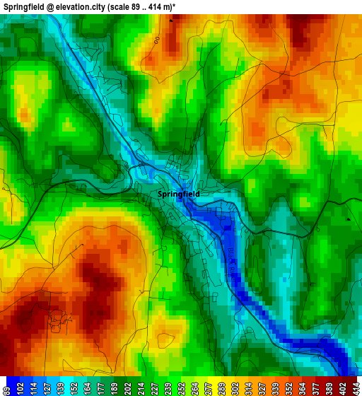
Below is the Elevation map of Springfield, which displays elevation range with different colors. Scale of the first map is from 89 to 414 m (292 to 1358 ft) with average elevation of 242.8 meters (=797 ft) [note 1]
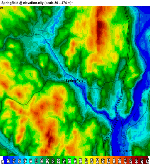
These maps also provides idea of topography and contour of this city, they are displayed at different zoom levels. More info about maps, scale and edge coordinates you can find below images.
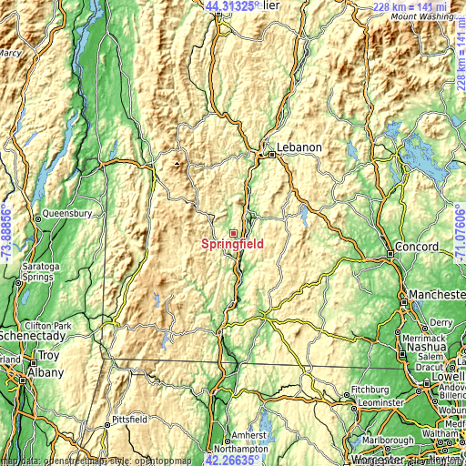
| \ | Map #1 | Map #2 | Topo.Map |
| Scale [m] | 89..414 m | 86..474 m | × |
| Scale [ft] | 292..1358 ft | 282..1555 ft | × |
| Average | 242.8 m = 797 ft | 240.7 m = 790 ft | × |
| Width | 7.11 km = 4.4 mi | 14.22 km = 8.8 mi | 227.6 km = 141.4 mi |
| Height | 7.11 km = 4.4 mi | 14.22 km = 8.8 mi | 227.6 km = 141.4 mi |
| ↑Max Latitude | 43.330385° | 43.362342° | 44.31325° |
| Latitude at center | 43.29841° | 43.29841° | 43.29841° |
| ↓Min Latitude | 43.266419° | 43.23441° | 42.26635° |
| ← Min Longitude | -72.526255° | -72.570201° | -73.88856° |
| Longitude center | -72.48231° | -72.48231° | -72.48231° |
| →Max Longitude | -72.438365° | -72.394419° | -71.07606° |
Nearby cities:
Cities around Springfield sort by population:
• Claremont elevation 152 m
14 km,  51°
51°
• Rockingham 151 m
12.3 km,  182°
182°
• Newport 250 m
26.1 km,  73°
73°
• Bellows Falls 102 m
18.6 km,  170°
170°
• Chester 188 m
9.9 km,  246°
246°
• Alstead 148 m
19.3 km,  149°
149°
• Windsor 103 m
21.7 km,  21°
21°
• Londonderry 352 m
27.4 km, 253°
• Unity 448 m
18 km,  91°
91°
• Townshend 176 m
31.7 km,  208°
208°
• Charlestown 120 m
8.1 km,  144°
144°
• Lempster 430 m
23 km,  106°
106°
Multilingual:
 En español:
Springfield elevación 124 m.
 En France:
Springfield élévation 124 m.
 Auf Deutsch:
Springfield höhe über dem Meeresspiegel ist 124 m.

Sources and notes:
- [note 1] Map square and city borders are not equal. Map elevation data is calculated only from area inside that square.
- [src 1] Elevation data from geonames database provided with same terms of usage.
- [src 2] The elevation map of Springfield is generated using elevation data from NASA's 3 arcsec (90m) resolution SRTM data.
- [src 3] Base (background) map © OpenStreetMap contributors tiles are generated by Geofabrik and OpenTopoMap.
Copyright & License:
This Springfield Elevation Map is licensed under CC BY-SA. You may reuse any part from this page, if you give a proper credit by linking to this URL:
 More info on terms of use page.