Newport elevation
Newport (New Hampshire, Sullivan County), United States elevation is 250 meters and Newport elevation in feet is 820 ft above sea level [src 1]. Newport is a seat of a second-order administrative division (feature code) with elevation that is 29 meters (95 ft) smaller than average city elevation in United States.
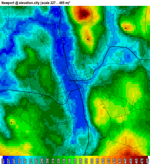
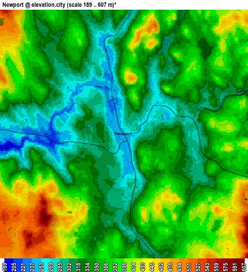
Below is the Elevation map of Newport, which displays elevation range with different colors. Scale of the first map is from 227 to 485 m (745 to 1591 ft) with average elevation of 306.2 meters (=1005 ft) [note 1]
These maps also provides idea of topography and contour of this city, they are displayed at different zoom levels. More info about maps, scale and edge coordinates you can find below images.
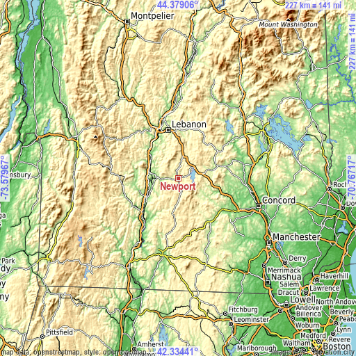
| \ | Map #1 | Map #2 | Topo.Map |
| Scale [m] | 227..485 m | 189..607 m | × |
| Scale [ft] | 745..1591 ft | 620..1991 ft | × |
| Average | 306.2 m = 1005 ft | 355 m = 1165 ft | × |
| Width | 7.1 km = 4.4 mi | 14.21 km = 8.8 mi | 227.3 km = 141.2 mi |
| Height | 7.1 km = 4.4 mi | 14.21 km = 8.8 mi | 227.3 km = 141.2 mi |
| ↑Max Latitude | 43.397289° | 43.429212° | 44.37906° |
| Latitude at center | 43.36535° | 43.36535° | 43.36535° |
| ↓Min Latitude | 43.333394° | 43.301421° | 42.33441° |
| ← Min Longitude | -72.217365° | -72.261311° | -73.57967° |
| Longitude center | -72.17342° | -72.17342° | -72.17342° |
| →Max Longitude | -72.129475° | -72.085529° | -70.76717° |
Nearby cities:
Cities around Newport sort by population:
• Claremont elevation 152 m
14.1 km,  275°
275°
• Sunapee 314 m
7.3 km,  70°
70°
• Grantham 294 m
14.1 km,  11°
11°
• Windsor 103 m
21.3 km,  306°
306°
• Newbury 341 m
12.1 km,  113°
113°
• Sutton 227 m
18.3 km,  100°
100°
• Unity 448 m
10.6 km,  221°
221°
• New London 395 m
16.1 km, 70°
• Wilmot 267 m
23.1 km, 65°
• Charlestown 120 m
24.7 km,  235°
235°
• Lempster 430 m
14.4 km,  192°
192°
• Springfield 446 m
18.3 km,  38°
38°
Multilingual:
 En español:
Newport elevación 250 m.
 En France:
Newport élévation 250 m.


Sources and notes:
- [note 1] Map square and city borders are not equal. Map elevation data is calculated only from area inside that square.
- [src 1] Elevation data from geonames database provided with same terms of usage.
- [src 2] The elevation map of Newport is generated using elevation data from NASA's 3 arcsec (90m) resolution SRTM data.
- [src 3] Base (background) map © OpenStreetMap contributors tiles are generated by Geofabrik and OpenTopoMap.
Copyright & License:
This Newport Elevation Map is licensed under CC BY-SA. You may reuse any part from this page, if you give a proper credit by linking to this URL:
 More info on terms of use page.