Lyndon elevation
Lyndon (Vermont, Caledonia County), United States elevation is 229 meters and Lyndon elevation in feet is 751 ft above sea level [src 1]. Lyndon is a populated place (feature code) with elevation that is 50 meters (164 ft) smaller than average city elevation in United States.
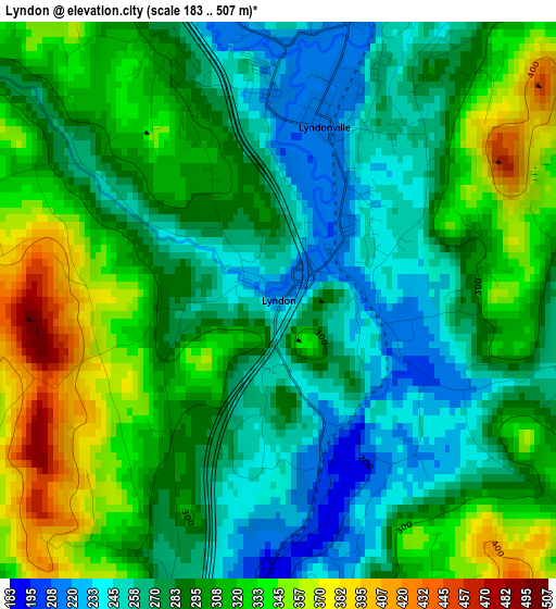
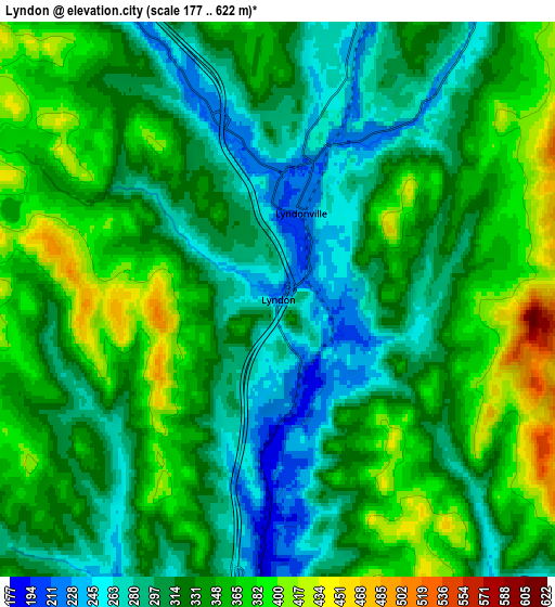
Below is the Elevation map of Lyndon, which displays elevation range with different colors. Scale of the first map is from 183 to 507 m (600 to 1663 ft) with average elevation of 295.5 meters (=969 ft) [note 1]
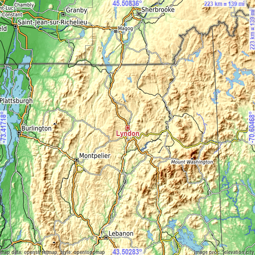
These maps also provides idea of topography and contour of this city, they are displayed at different zoom levels. More info about maps, scale and edge coordinates you can find below images.
| \ | Map #1 | Map #2 | Topo.Map |
| Scale [m] | 183..507 m | 177..622 m | × |
| Scale [ft] | 600..1663 ft | 581..2041 ft | × |
| Average | 295.5 m = 969 ft | 328.9 m = 1079 ft | × |
| Width | 6.97 km = 4.3 mi | 13.94 km = 8.7 mi | 223 km = 138.6 mi |
| Height | 6.97 km = 4.3 mi | 13.94 km = 8.7 mi | 223 km = 138.6 mi |
| ↑Max Latitude | 44.545548° | 44.576859° | 45.50836° |
| Latitude at center | 44.51422° | 44.51422° | 44.51422° |
| ↓Min Latitude | 44.482875° | 44.451514° | 43.50283° |
| ← Min Longitude | -72.054875° | -72.098821° | -73.41718° |
| Longitude center | -72.01093° | -72.01093° | -72.01093° |
| →Max Longitude | -71.966985° | -71.923039° | -70.60468° |
Nearby cities:
Cities around Lyndon sort by population:
• St Johnsbury elevation 188 m
9.9 km,  181°
181°
• Saint Johnsbury 179 m
10.6 km, 181°
• Littleton 246 m
30 km,  140°
140°
• Northumberland 263 m
36.3 km,  81°
81°
• Lancaster 266 m
35.1 km,  94°
94°
• Hardwick 252 m
28.3 km,  267°
267°
• Lunenburg 360 m
26.7 km,  102°
102°
• Lyndonville 217 m
2.2 km,  15°
15°
• Whitefield 294 m
35.5 km,  116°
116°
• Woodsville 138 m
40.3 km, 182°
• Stratford 268 m
39.3 km,  66°
66°
• Guildhall 263 m
36.2 km, 81°
Multilingual:
 En español:
Lyndon elevación 229 m.
 En France:
Lyndon élévation 229 m.


Sources and notes:
- [note 1] Map square and city borders are not equal. Map elevation data is calculated only from area inside that square.
- [src 1] Elevation data from geonames database provided with same terms of usage.
- [src 2] The elevation map of Lyndon is generated using elevation data from NASA's 3 arcsec (90m) resolution SRTM data.
- [src 3] Base (background) map © OpenStreetMap contributors tiles are generated by Geofabrik and OpenTopoMap.
Copyright & License:
This Lyndon Elevation Map is licensed under CC BY-SA. You may reuse any part from this page, if you give a proper credit by linking to this URL:
 More info on terms of use page.