Littleton elevation
Littleton (New Hampshire, Grafton County), United States elevation is 246 meters and Littleton elevation in feet is 807 ft above sea level [src 1]. Littleton is a populated place (feature code) with elevation that is 33 meters (108 ft) smaller than average city elevation in United States.
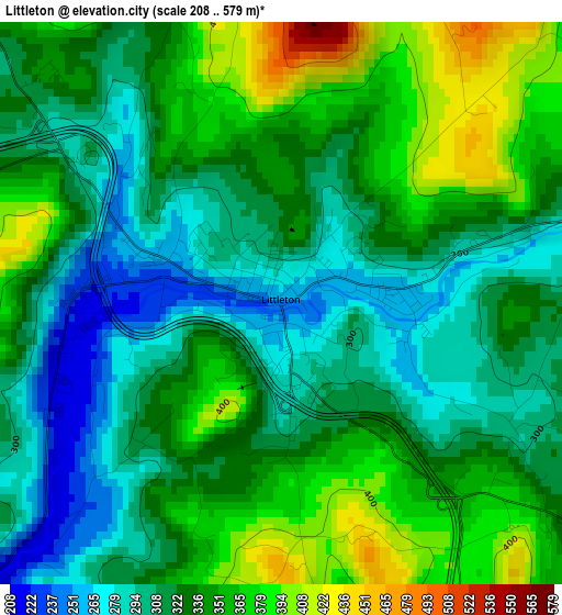
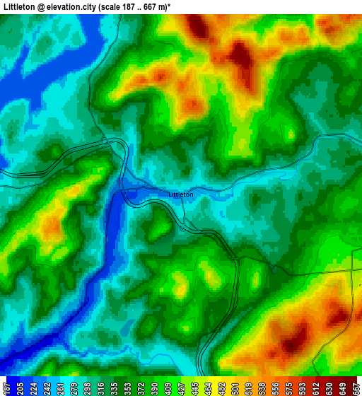
Below is the Elevation map of Littleton, which displays elevation range with different colors. Scale of the first map is from 208 to 579 m (682 to 1900 ft) with average elevation of 330.1 meters (=1083 ft) [note 1]
These maps also provides idea of topography and contour of this city, they are displayed at different zoom levels. More info about maps, scale and edge coordinates you can find below images.
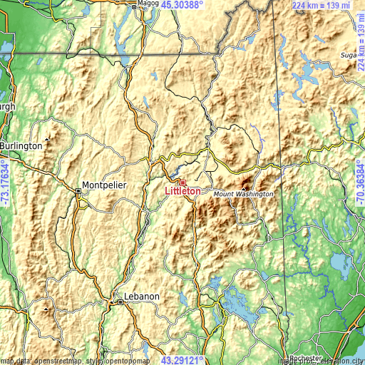
| \ | Map #1 | Map #2 | Topo.Map |
| Scale [m] | 208..579 m | 187..667 m | × |
| Scale [ft] | 682..1900 ft | 614..2188 ft | × |
| Average | 330.1 m = 1083 ft | 362 m = 1188 ft | × |
| Width | 6.99 km = 4.3 mi | 13.99 km = 8.7 mi | 223.8 km = 139.1 mi |
| Height | 6.99 km = 4.3 mi | 13.99 km = 8.7 mi | 223.8 km = 139.1 mi |
| ↑Max Latitude | 44.33761° | 44.369032° | 45.30388° |
| Latitude at center | 44.30617° | 44.30617° | 44.30617° |
| ↓Min Latitude | 44.274714° | 44.24324° | 43.29121° |
| ← Min Longitude | -71.814035° | -71.857981° | -73.17634° |
| Longitude center | -71.77009° | -71.77009° | -71.77009° |
| →Max Longitude | -71.726145° | -71.682199° | -70.36384° |
Nearby cities:
Cities around Littleton sort by population:
• St Johnsbury elevation 188 m
23.6 km,  304°
304°
• Saint Johnsbury 179 m
23.2 km, 302°
• Lyndon 229 m
30 km,  320°
320°
• Deerfield 484 m
14.8 km,  124°
124°
• Northumberland 263 m
33.2 km,  30°
30°
• Lancaster 266 m
25.8 km,  38°
38°
• Lunenburg 360 m
18.8 km,  21°
21°
• Lyndonville 217 m
31.3 km, 323°
• Whitefield 294 m
14.7 km,  59°
59°
• Woodsville 138 m
27.3 km,  231°
231°
• Jefferson 428 m
26.6 km, 61°
• North Haverhill 152 m
31.5 km,  220°
220°
Multilingual:
 En español:
Littleton elevación 246 m.
 En France:
Littleton élévation 246 m.
 Auf Deutsch:
Littleton höhe über dem Meeresspiegel ist 246 m.

Sources and notes:
- [note 1] Map square and city borders are not equal. Map elevation data is calculated only from area inside that square.
- [src 1] Elevation data from geonames database provided with same terms of usage.
- [src 2] The elevation map of Littleton is generated using elevation data from NASA's 3 arcsec (90m) resolution SRTM data.
- [src 3] Base (background) map © OpenStreetMap contributors tiles are generated by Geofabrik and OpenTopoMap.
Copyright & License:
This Littleton Elevation Map is licensed under CC BY-SA. You may reuse any part from this page, if you give a proper credit by linking to this URL:
 More info on terms of use page.