Lancaster elevation
Lancaster (New Hampshire, Coos County), United States elevation is 266 meters and Lancaster elevation in feet is 873 ft above sea level [src 1]. Lancaster is a seat of a second-order administrative division (feature code) with elevation that is 13 meters (43 ft) smaller than average city elevation in United States.
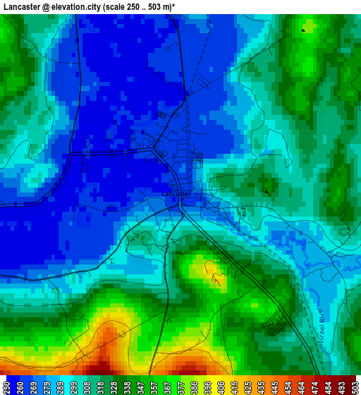
Below is the Elevation map of Lancaster, which displays elevation range with different colors. Scale of the first map is from 250 to 503 m (820 to 1650 ft) with average elevation of 307.6 meters (=1009 ft) [note 1]
These maps also provides idea of topography and contour of this city, they are displayed at different zoom levels. More info about maps, scale and edge coordinates you can find below images.
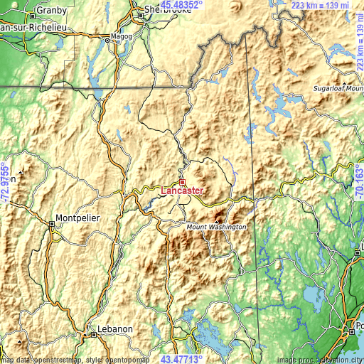
| \ | Map #1 | Topo.Map |
| Scale [m] | 250..503 m | × |
| Scale [ft] | 820..1650 ft | × |
| Average | 307.6 m = 1009 ft | × |
| Width | 6.97 km = 4.3 mi | 223.1 km = 138.6 mi |
| Height | 6.97 km = 4.3 mi | 223.1 km = 138.6 mi |
| ↑Max Latitude | 44.520292° | 45.48352° |
| Latitude at center | 44.48895° | 44.48895° |
| ↓Min Latitude | 44.457592° | 43.47713° |
| ← Min Longitude | -71.613195° | -72.9755° |
| Longitude center | -71.56925° | -71.56925° |
| →Max Longitude | -71.525305° | -70.163° |
Nearby cities:
Cities around Lancaster sort by population:
• Berlin elevation 312 m
30.6 km,  94°
94°
• Littleton 246 m
25.8 km,  218°
218°
• Deerfield 484 m
29 km,  187°
187°
• Northumberland 263 m
8.3 km,  5°
5°
• Gorham 244 m
33.4 km,  109°
109°
• Milan 344 m
31.9 km,  72°
72°
• Lunenburg 360 m
9.4 km,  252°
252°
• Whitefield 294 m
13.3 km, 194°
• Groveton 268 m
13 km,  20°
20°
• Jefferson 428 m
10.8 km,  135°
135°
• Stratford 268 m
18.5 km,  3°
3°
• Guildhall 263 m
8.5 km, 5°
Multilingual:
 En español:
Lancaster elevación 266 m.
 En France:
Lancaster élévation 266 m.
 Auf Deutsch:
Lancaster höhe über dem Meeresspiegel ist 266 m.

Sources and notes:
- [note 1] Map square and city borders are not equal. Map elevation data is calculated only from area inside that square.
- [src 1] Elevation data from geonames database provided with same terms of usage.
- [src 2] The elevation map of Lancaster is generated using elevation data from NASA's 3 arcsec (90m) resolution SRTM data.
- [src 3] Base (background) map © OpenStreetMap contributors tiles are generated by Geofabrik and OpenTopoMap.
Copyright & License:
This Lancaster Elevation Map is licensed under CC BY-SA. You may reuse any part from this page, if you give a proper credit by linking to this URL:
 More info on terms of use page.