Williamstown elevation
Williamstown (Pennsylvania, Dauphin County), United States elevation is 227 meters and Williamstown elevation in feet is 745 ft above sea level [src 1]. Williamstown is a populated place (feature code) with elevation that is 52 meters (171 ft) smaller than average city elevation in United States.
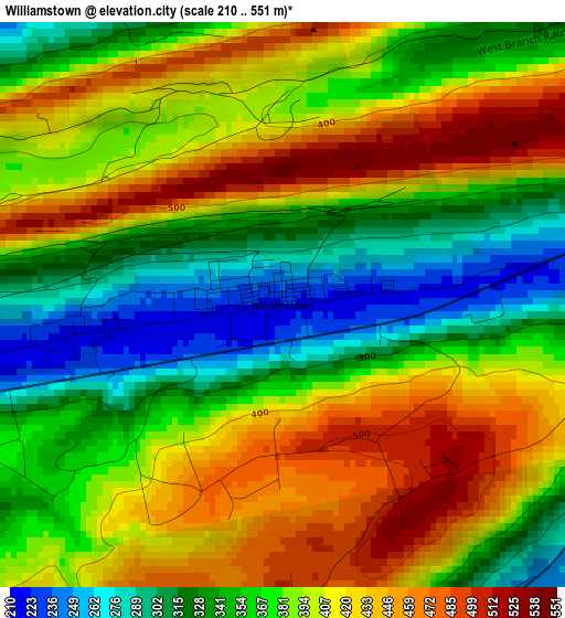
Below is the Elevation map of Williamstown, which displays elevation range with different colors. Scale of the first map is from 210 to 551 m (689 to 1808 ft) with average elevation of 383.9 meters (=1260 ft) [note 1]
These maps also provides idea of topography and contour of this city, they are displayed at different zoom levels. More info about maps, scale and edge coordinates you can find below images.
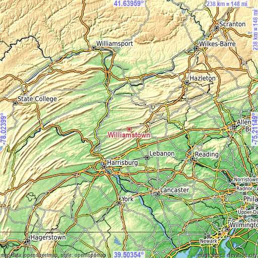
| \ | Map #1 | Topo.Map |
| Scale [m] | 210..551 m | × |
| Scale [ft] | 689..1808 ft | × |
| Average | 383.9 m = 1260 ft | × |
| Width | 7.42 km = 4.6 mi | 237.5 km = 147.6 mi |
| Height | 7.42 km = 4.6 mi | 237.5 km = 147.6 mi |
| ↑Max Latitude | 40.613458° | 41.63959° |
| Latitude at center | 40.58009° | 40.58009° |
| ↓Min Latitude | 40.546705° | 39.50354° |
| ← Min Longitude | -76.661685° | -78.02399° |
| Longitude center | -76.61774° | -76.61774° |
| →Max Longitude | -76.573795° | -75.21149° |
Nearby cities:
Cities around Williamstown sort by population:
• Shamokin elevation 219 m
23.8 km,  12°
12°
• Edgewood 243 m
23.5 km, 9°
• Pine Grove 168 m
20 km,  100°
100°
• Fairview-Ferndale 301 m
22.6 km, 9°
• Jonestown 148 m
21.9 km,  147°
147°
• Trevorton 260 m
22.8 km,  348°
348°
• Lykens 215 m
7.1 km,  258°
258°
• Tremont 236 m
20.2 km,  74°
74°
• Valley View 246 m
9.9 km,  42°
42°
• Elizabethville 206 m
16.8 km, 258°
• Fredericksburg 146 m
22.1 km,  133°
133°
• Tower City 242 m
5.6 km,  79°
79°
Multilingual:
 En español:
Williamstown elevación 227 m.
 En France:
Williamstown élévation 227 m.
 Auf Deutsch:
Williamstown höhe über dem Meeresspiegel ist 227 m.

Sources and notes:
- [note 1] Map square and city borders are not equal. Map elevation data is calculated only from area inside that square.
- [src 1] Elevation data from geonames database provided with same terms of usage.
- [src 2] The elevation map of Williamstown is generated using elevation data from NASA's 3 arcsec (90m) resolution SRTM data.
- [src 3] Base (background) map © OpenStreetMap contributors tiles are generated by Geofabrik and OpenTopoMap.
Copyright & License:
This Williamstown Elevation Map is licensed under CC BY-SA. You may reuse any part from this page, if you give a proper credit by linking to this URL:
 More info on terms of use page.